We Recommend:
Bach Steel - Experts at historic truss bridge restoration.
BridgeHunter.com Phase 1 is released to the public! - Visit Now
Roosevelt Road Bridge
12th Street Bridge

Primary Photographer(s): Nathan Holth
Bridge Documented: October 1, 2010 and March 9, 2016
Chicago: Cook County, Illinois: United States
Metal Rivet-Connected Pratt Deck Truss, Movable: Double Leaf Bascule (Fixed Trunnion) and Approach Spans: Metal Stringer (Multi-Beam), Fixed
1928 By Builder/Contractor: Ketler-Elliott Company of Chicago, Illinois and Engineer/Design: City of Chicago
1994
204.0 Feet (62.2 Meters)
257.6 Feet (78.5 Meters)
71.9 Feet (21.92 Meters)
1 Main Span(s) and 2 Approach Span(s)
16604726651

View Information About HSR Ratings
Bridge Documentation
View Archived National Bridge Inventory Report - Has Additional Details and Evaluation
View Historical Articles About This Bridge
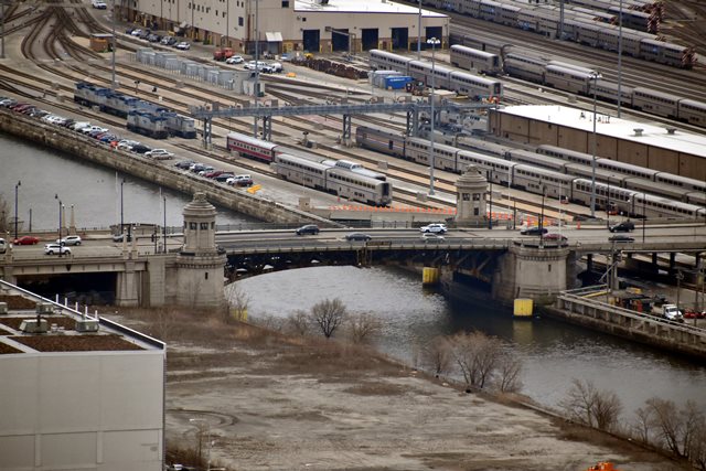
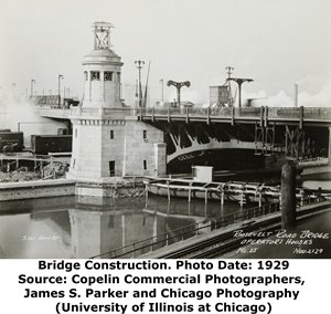
Roosevelt Road was originally known as 12th Street and this associated bascule bridge and approach system were called the 12th Street Viaduct. This bridge is an example of a Chicago Pratt truss bascule bridge that is a true deck truss, where the truss does not partially extend above the deck and is also not a double-deck truss. There are only a few bridges of this type in Chicago, and the Roosevelt Road is perhaps most similar to the Ohio Street Bridge. Perhaps the most striking feature of the bridge is the two beautiful circular-shaped bridgetender buildings that feature decorative sculptures set into the buildings. These round buildings are unlike bridgetender buildings found elsewhere in Chicago, and they are very pleasing aesthetically. Large plaques mounted on the buildings are themselves curved so as to conform to the round shape of the buildings. The buildings appear to be in excellent, unaltered condition.
A very long (over 1000 feet total) length of viaduct provides an approach to the bridge. The viaduct approach structures are not considered part of the historic bridge as they appear to have been extensively altered and/or reconstructed.
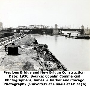
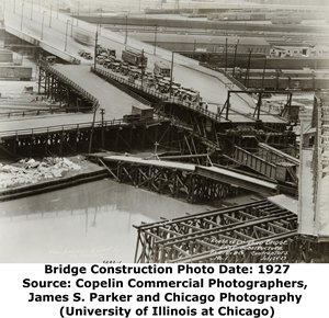
This bridge was built at the same time that the South Branch of the Chicago River was being realigned to the west. Roosevelt Road is near the northern end of where the realignment project took place. The former swing bridge at this location was located just east of where the current bascule bridge is located. The historic construction photo to the right shows both the swing bridge crossing the old South Branch channel and the nearly completed bascule bridge crossing the new South Branch channel. The bascule bridge was built before the new alignment of the river was dug. Because of this fact as well as the desire to maintain traffic on the road during construction, the construction of this bridge took on an unusual appearance. The bridge was built in the raised position so as not to block the old roadway. One of the trusses can be seen in the historical photo to the left poking right up through the middle of the old roadway. Because the new alignment of the river had not been dug, it also would have looked like this was a bridge being built over nothing, since there would have been dry land under the bridge.
Given the large and complex nature of this bridge project, substantial preliminary studies were conducted prior to building the bridge. The 1914 Annual Report of the Department of Public Works included a discussion of some of the planning efforts. Several movable bridge types were considered. A city-designed vertical lift bridge was given serious consideration, with the city going as far as preparing detailed plans. Unsurprisingly, alternative designs of trunnion bascule bridges were also considered. Also of note, the city gave considerations for a plan submitted by the Strauss Bascule Bridge Company for a "direct lift" bascule bridge, an unusual type of vertical lift bridge designed by famous engineer Joseph Strauss. An example can be found in British Columbia.
Hugh E. Young was Chief Engineer for the Chicago Plan Commission when this bridge was built. Hugh E. Young also served as Engineer of Bridge for the city in previous years. Click his photograph shown to view a larger image that includes a short biography.
Today, the bridge carries the very busy Roosevelt Road, with an Average Daily Traffic of 37,000. The Roosevelt Road Bridge's truss superstructure has been extensively built-up and strengthened during rehabilitation, which occurred in 1994. Numerous rivets have been replaced with bolts on the truss. These alterations have diminished the historic integrity of the truss, however the bridge does score very high structural evaluation ratings on the National Bridge Inventory suggesting that these alterations did extend the life of the bridge considerably. As of 2010 there is some rust forming on the truss however. If Chicago DOT continues its track record, it is likely the bridge will be repainted in the maroon paint color the city uses on all of its most recent bridge repainting projects.
The 1930 Annual Report of the Public Works Department stated a number of facts for the bridge. 620,000 pounds of reinforcing steel were placed in the bridge's substructure. The total weight of steel for the bridge was 1,950 tons. Each leaf, including counterweight was 1,560 tons. Each leaf was mounted on two trunnions, each with a 24 inch diameter and each carrying 780 tons. The total weight of machinery was 212 tons. The bridge was operated with two 75 H.P. electric motors. It was mentioned that the original railings were an aluminum alloy. Fitzsimons & Connell Dredge & Dock Company constructed the eastern substructure, while M. E. White Company did the western substructure. Ketler-Elliott Company constructed the superstructure. Norwood-Noonan Company installed electrical equipment. The bridge tender houses were built by the C. E. Carson Company. William J. Gormley Company installed plumbing.

Photo Credit: Patrick Hynes
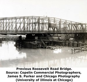
Above: This is the swing bridge that preceded the existing bascule bridge. It was built in 1886 by the Chicago Forge and Bolt Company and was a steel swing bridge. The swing bridge was 220 feet long and 59 feet wide. It was powered by steam. This swing bridge was preceeded by the first documented bridge at this location, a hand-turned, combination wood/iron swing bridge built by Fox and Howard in 1868.
|
Main Plaque ROOSEVELT ROAD BRIDGE WM HALE THOMPSON RICHARD W. WOLFE
CHICAGO PLAN COMMISSION
CONTRACTORS FITZSIMONS & CONNELL DREDGE & DOCK CO.
NORWOOD - NOONAN CO C. E. CARSON CO. |
River Straightening Plaque RIVER STRAIGHTENING WM HALE THOMPSON RICHARD W. WOLFE EDWARD F. MOORE
COMMITTEE ON RAILWAY TERMINALS
CHICAGO PLAN COMMISSION
HUGH E. YOUNG, CHIEF ENGINEER GREAT LAKES DREDGE & DOCK CO. CONTRACTOR |
Bridge Rehabilitation Plaque ROOSEVELT ROAD BASCULE BRIDGE RESTORATION 1994 CITY OF CHICAGO RICHARD M. DALEY, MAYOR |
![]()
Historic Bridges of Chicago and Cook County


Chicago and Cook County are home to one of the largest collections of historic bridges in the country, and no other city in the world has more movable bridges. HistoricBridges.org is proud to offer the most extensive coverage of historic Chicago bridges on the Internet.
General Chicago / Cook County Bridge Resources
Chicago's Bridges - By Nathan Holth, author of HistoricBridges.org, this book provides a discussion of the history of Chicago's movable bridges, and includes a virtual tour discussing all movable bridges remaining in Chicago today. Despite this broad coverage, the book is presented in a compact format that is easy to take with you and carry around for reference on a visit to Chicago. The book includes dozens of full color photos. Only $9.95 U.S! ($11.95 Canadian). Order on Amazon.
Chicago River Bridges - By Patrick T. McBriarty, this is a great companion to Holth's book shown above. This much larger book offers an extremely in-depth exploration of Chicago's movable highway bridges, including many crossings that have not existed for many years. Order Now Direct From The Publisher! or order on Amazon.
View Historic American Engineering Record (HAER) Overview of Chicago Bascule Bridges (HAER Data Pages, PDF)
Chicago Loop Bridges - Chicago Loop Bridges is another website on the Internet that is a great companion to the HistoricBridges.org coverage of the 18 movable bridges within the Chicago Loop. This website includes additional information such as connections to popular culture, overview discussions and essays about Chicago's movable bridges, additional videos, and current news and events relating to the bridges.
Additional Online Articles and Resources - This page is a large gathering of interesting articles and resources that HistoricBridges.org has uncovered during research, but which were not specific to a particular bridge listing.
This bridge is tagged with the following special condition(s): Unorganized Photos
![]()
Photo Galleries and Videos: Roosevelt Road Bridge
Bridge Photo-Documentation
Original / Full Size PhotosA collection of overview and detail photos. This gallery offers photos in the highest available resolution and file size in a touch-friendly popup viewer.
Alternatively, Browse Without Using Viewer
![]()
Bridge Photo-Documentation
Mobile Optimized PhotosA collection of overview and detail photos. This gallery features data-friendly, fast-loading photos in a touch-friendly popup viewer.
Alternatively, Browse Without Using Viewer
![]()
Additional Unorganized Photos
Original / Full Size PhotosA supplemental collection of photos that are from additional visit(s) to the bridge and have not been organized or captioned. This gallery offers photos in the highest available resolution and file size in a touch-friendly popup viewer.
Alternatively, Browse Without Using Viewer
![]()
Additional Unorganized Photos
Mobile Optimized PhotosA supplemental collection of photos that are from additional visit(s) to the bridge and have not been organized or captioned. This gallery features data-friendly, fast-loading photos in a touch-friendly popup viewer.
Alternatively, Browse Without Using Viewer
![]()
Maps and Links: Roosevelt Road Bridge
Coordinates (Latitude, Longitude):
Search For Additional Bridge Listings:
Bridgehunter.com: View listed bridges within 0.5 miles (0.8 kilometers) of this bridge.
Bridgehunter.com: View listed bridges within 10 miles (16 kilometers) of this bridge.
Additional Maps:
Google Streetview (If Available)
GeoHack (Additional Links and Coordinates)
Apple Maps (Via DuckDuckGo Search)
Apple Maps (Apple devices only)
Android: Open Location In Your Map or GPS App
Flickr Gallery (Find Nearby Photos)
Wikimedia Commons (Find Nearby Photos)
Directions Via Sygic For Android
Directions Via Sygic For iOS and Android Dolphin Browser
USGS National Map (United States Only)
Historical USGS Topo Maps (United States Only)
Historic Aerials (United States Only)
CalTopo Maps (United States Only)

