We Recommend:
Bach Steel - Experts at historic truss bridge restoration.
Ashland Avenue North Branch Bridge

Primary Photographer(s): Nathan Holth
Bridge Documented: May 31, 2009 and May 14, 2012
Chicago: Cook County, Illinois: United States
Metal Rivet-Connected Pratt Pony Truss, Movable: Double Leaf Bascule (Fixed Trunnion) and Approach Spans: Metal Stringer (Multi-Beam), Fixed
1936 By Builder/Contractor: Ketler-Elliott Company of Chicago, Illinois and Engineer/Design: City of Chicago
1993
232.0 Feet (70.7 Meters)
386.5 Feet (117.8 Meters)
60 Feet (18.29 Meters)
1 Main Span(s) and 4 Approach Span(s)
16600226634

View Information About HSR Ratings
Bridge Documentation
This bridge's future is at risk!
Bridge Status: This historic bridge has an uncertain future, however it has been recommended for Chicago Landmark designation by the Chicago Art Deco Society!View Archived National Bridge Inventory Report - Has Additional Details and Evaluation

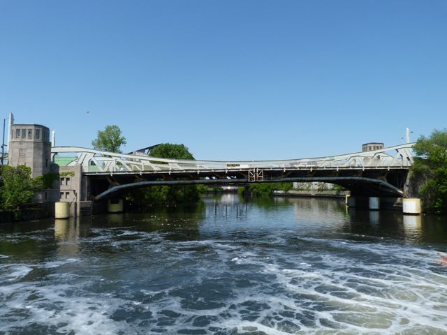
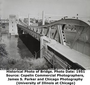
The Ashland Avenue Bridge over North Branch Chicago River is an example of one of Chicago's smoothly curved pony truss bascules. Perhaps the most graceful of the many Chicago bridge forms, the bridge conveys almost a modern and simplistic appearance, while also maintaining the geometric complexity which makes truss bridges so intriguing to the eye. This particular bridge is further embellished by bridge tender towers which include beautiful decorative relief panels with depictions of persons holding various parts of the bridge, such as the trusses, bridge tender builders, gears, etc. This is the only remaining Chicago bascule bridge to display these depictions (A bridge with similar depictions on Ogden Avenue was demolished in 1995), which is clear evidence of the individual significance of this bridge among the many historic bridges within the Chicago bascule bridge group. Scippione Del Campo was the artist and architect who crafted these beautiful panels.
This bridge is the northernmost highway example of the greatest collection of historic bascule bridges on the planet, which is located in the city Chicago and Cook County. The fact that Chicago is a city with such a large, record-breaking number of bascule bridges, and most of them considered historic, is something the city should be truly proud of. For the most part, Chicago has been a model for historic bridge preservation, especially with the bridges in the downtown area. They have chosen to maintain, and rehabilitate as needed, their historic bridges for the continuous heavy traffic one might expect in the nation's third largest city. The fact that so many of these bridges remain functional and historically intact as well sends a message to other cities and even rural locations who claim that historic bridges cannot serve the needs of modern day traffic.
While Chicago is a leader in historic bridge preservation downtown, how do the city's historic bridges fare out away from the core of the city? Their conditions vary widely, some remain in excellent condition, while others show need of rehabilitation. How does the city's commitment to preservation stand outside of the downtown? This remains to be seen for certain, with initial evidence pointing in both directions. Certainly, nearby Cortland Street Bridge displays a commitment to preservation, having been continuously maintained and preserved the past few years. However, it is worth noting that Ashland Avenue Bridge was not always the northernmost historic movable highway bridge in Chicago. Nearby Damen Avenue Bridge to the north was demolished and replaced with a modern through arch that, while more attractive than a normal modern bridge, does not convey Chicago's movable bridge or industrial heritage, and does not blend into the context of Chicago bridges or the canalized river in which they cross. It is impossible to make a connection to Chicago's past, or the canal's past with this new bridge.

Many of the movable bridges on the North Branch and South Branch (Sanitary Canal) of Chicago River are unlike those on the main branch and downtown Chicago. In addition, some of the oldest and most historic bascule bridges are on the North Branch. It is essential that these outlying bridges be preserved alongside the core downtown movable bridges. Moving forward, if Chicago wishes to maintain its image as the worldwide capital of bascule bridges, and if it also wishes to maintain its image as one of this nation's great Historic Bridge Cities alongside cities like Pittsburgh, a preservation plan for its remaining historic bascule bridges should be put in place.
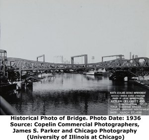
The bridge cost $1,700,000 to construct and more than 10,000 people attending the opening ceremonies. American Bridge Company of New York, New York fabricated the superstructure, while the on-site contractor for the superstructure was Ketler-Elliott Company of Chicago, Illinois. The below photo shows the bridge superstructure completed, although the bridge tender houses remain structural skeletons awaiting their facing.
![]()
Historic Bridges of Chicago and Cook County


Chicago and Cook County are home to one of the largest collections of historic bridges in the country, and no other city in the world has more movable bridges. HistoricBridges.org is proud to offer the most extensive coverage of historic Chicago bridges on the Internet.
General Chicago / Cook County Bridge Resources
Chicago's Bridges - By Nathan Holth, author of HistoricBridges.org, this book provides a discussion of the history of Chicago's movable bridges, and includes a virtual tour discussing all movable bridges remaining in Chicago today. Despite this broad coverage, the book is presented in a compact format that is easy to take with you and carry around for reference on a visit to Chicago. The book includes dozens of full color photos. Only $9.95 U.S! ($11.95 Canadian). Order Now Direct From The Publisher! or order on Amazon.
Chicago River Bridges - By Patrick T. McBriarty, this is a great companion to Holth's book shown above. This much larger book offers an extremely in-depth exploration of Chicago's movable highway bridges, including many crossings that have not existed for many years. Order Now Direct From The Publisher! or order on Amazon.
View Historic American Engineering Record (HAER) Overview of Chicago Bascule Bridges (HAER Data Pages, PDF)
Chicago Loop Bridges - Chicago Loop Bridges is another website on the Internet that is a great companion to the HistoricBridges.org coverage of the 18 movable bridges within the Chicago Loop. This website includes additional information such as connections to popular culture, overview discussions and essays about Chicago's movable bridges, additional videos, and current news and events relating to the bridges.
Additional Online Articles and Resources - This page is a large gathering of interesting articles and resources that HistoricBridges.org has uncovered during research, but which were not specific to a particular bridge listing.
![]()
Photo Galleries and Videos: Ashland Avenue North Branch Bridge
Bridge Photo-Documentation
Original / Full Size PhotosA collection of overview and detail photos. This gallery offers photos in the highest available resolution and file size in a touch-friendly popup viewer.
Alternatively, Browse Without Using Viewer
![]()
Bridge Photo-Documentation
Mobile Optimized PhotosA collection of overview and detail photos. This gallery features data-friendly, fast-loading photos in a touch-friendly popup viewer.
Alternatively, Browse Without Using Viewer
![]()
Bumpercam: Southbound Crossing
Full Motion VideoNote: The downloadable high quality version of this video (available on the video page) is well worth the download since it offers excellent 1080 HD detail and is vastly more impressive than the compressed streaming video. Streaming video of the bridge. Also includes a higher quality downloadable video for greater clarity or offline viewing.
![]()
Maps and Links: Ashland Avenue North Branch Bridge
Coordinates (Latitude, Longitude):
Search For Additional Bridge Listings:
Bridgehunter.com: View listed bridges within 0.5 miles (0.8 kilometers) of this bridge.
Bridgehunter.com: View listed bridges within 10 miles (16 kilometers) of this bridge.
Additional Maps:
Google Streetview (If Available)
GeoHack (Additional Links and Coordinates)
Apple Maps (Via DuckDuckGo Search)
Apple Maps (Apple devices only)
Android: Open Location In Your Map or GPS App
Flickr Gallery (Find Nearby Photos)
Wikimedia Commons (Find Nearby Photos)
Directions Via Sygic For Android
Directions Via Sygic For iOS and Android Dolphin Browser
USGS National Map (United States Only)
Historical USGS Topo Maps (United States Only)
Historic Aerials (United States Only)
CalTopo Maps (United States Only)


