We Recommend:
Bach Steel - Experts at historic truss bridge restoration.
Chicago Avenue Bridge

Primary Photographer(s): Nathan Holth
Bridge Documented: August 12, 2006, 2010-2013
Chicago: Cook County, Illinois: United States
Metal Pratt Pony Truss, Movable: Double Leaf Bascule (Fixed Trunnion) and Approach Spans: Metal Stringer (Multi-Beam), Fixed
1914 By Builder/Contractor: Ketler-Elliott Company of Chicago, Illinois and Engineer/Design: City of Chicago
Not Available or Not Applicable
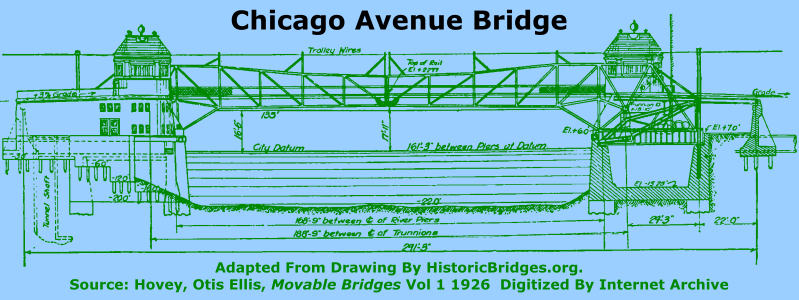
189.0 Feet (57.6 Meters)
291.0 Feet (88.7 Meters)
36 Feet (10.97 Meters)
1 Main Span(s) and 4 Approach Span(s)
16600826624

View Information About HSR Ratings
Bridge Documentation
This bridge no longer exists!
Bridge Status: Demolished in Fall 2018.View Archived National Bridge Inventory Report - Has Additional Details and Evaluation
View Historic American Engineering Record (HAER) Documentation For This Bridge
HAER Data Pages, PDF
About This Bridge
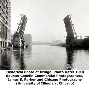
This bridge is similar to the nearby Grand Avenue Bridge. Both are examples of the first design of pony truss bascule bridge that Chicago came up with, often referred to as the second generation bascule bridge design. Additionally, the Chicago Avenue Bridge is historically significant for its unique concrete bridge tender house. This bridge was one of the first Chicago bascule bridges to employ a "permanent" bridge tender building that was constructed of materials more substantial than wood, which had been used previously. This change was perhaps also partly due to the increased attention to aesthetics that was being given to the city bridges at this time. For the Chicago Avenue Bridge, G. W. Maher and E. C. Jensen of the Illinois Chapter of the American Institute of Architects submitted designs on possible architectural treatment for the bridge, and these suggestions were integrated into the bridge design. It was around this time that the Chicago Plan Commission began collaborating with the city's Bridge Division during the design of bridges like the Chicago Avenue Bridge. Beginning with the Chicago Avenue Bridge and the Washington Boulevard Bridge, there was a marked increase in the aesthetic details of city bascule bridges. Sadly, some of the ornamental details for the Chicago Avenue Bridge appear to have been lost. The original design included decorative concrete posts located near the ends of the trusses, as well as decorative lighting standards on the approaches to the bridge.

The bridge as originally designed was powered by two 50 h.p. electric motors. The lower portions of the bridge tender houses were constructed of concrete, detailed to present the appearance of granite. The upper portions of the bridge tender houses were constructed with wood and covered with copper sheeting, and the roofs featured vitrified tile.
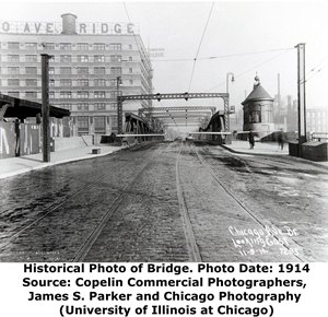
One irony of the second generation bascule bridges is that when they were originally built they would have still looked like a through truss because of the supports for the overhead catenary cables for electric trolleys. Looking at historical photos of this bridge which show these supports one has to wonder if the effort to design a bascule bridge that eliminated overhead bracing produced a worthwhile aesthetic benefit. Perhaps the engineers foresaw a day when the cable supports would be removed as indeed they eventually were? Although the removal of the supports is technically an alteration from original design, the visual appearance of the bridge today with the supports removed seems to produce a bridge that better displays an intended aesthetic. Visually, the supports looked like an afterthought... something added to the bridge later even though they were part of the original design.
The superstructure for the bridge was built by the Ketler-Elliott Erection Company. The substructure was completed by the Byrne Brothers Dredge and Engineering Company.
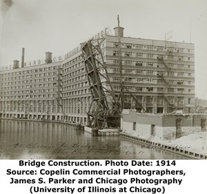
The first documented bridge was built in 1867 and was a wood/iron combination bridge built by Fox and Howard, which was a very prolific builder of Chicago bridges during that period. It was destroyed in the 1871 fire. The following year it was rebuilt in a similar design by the same company. During construction of the current bascule bridge, a temporary pontoon bridge was employed to maintain traffic during construction. The temporary pontoon bridge was all-new construction, not a reused bridge.
Chicago Heritage, Architecture, and Beauty At Risk
This bridge is at an extremely high risk for demolition and replacement, with plans to implement the project well underway! While Chicago has preserved its historic bridges in the downtown Loop area, there is a clear discrepancy on the North Branch Chicago River where the rate of demolition is very high, despite the fact that some of the most historically significant bridges in Chicago are on the North Branch. The city has proven that its historic bascule bridges can be rehabilitated, with parts replicated as needed, and this is what should instead be done with this bridge. The city should look to Cortland Street Bridge, Kinzie Street Bridge, and Wells Street Bridge as examples of the feasibility of preservation.
One of the reasons given for plans to demolish and replace this bridge is because of the high volume of traffic on it. However, providing a replacement bridge that is wider may be difficult given how close buildings are to the bridge. Most notably, a massive, historic Montgomery Ward building (a National Historic Landmark) that appears to have been preserved and adaptively reused is directly next to the bridge. If the high volume of traffic is a problem, perhaps there is a way to expand mass transit options in this part of the city. For example, a subway connecting the Blue Line to the Red Line in this area might be of benefit. The reality is that driving a car near downtown Chicago is not fun and is very expensive due to parking costs which will only get worse since Chicago signed away its parking meters to a private company for three quarters of a century, a company which immediately jacked up prices upon gaining control of the meters. If an alternative to driving was available in the Chicago Avenue corridor, perhaps traffic on the bridge could be reduced in this manner. Simply providing a wider bridge at Chicago Avenue is not going to suddenly make this Chicago street fast-moving and efficient. The problem is much deeper.
Ironically, a review of the 1911 Annual Report of the Department of Public Works noted that the city intended to eventually build a subway under Chicago Avenue, and so the Chicago Avenue Bridge was specially designed to accommodate the future construction of a double subway tunnel. The report stated that shafts filled with concrete were used instead of piles for the piers and abutments of the bridge for this very reason. Perhaps instead of condemning this historic bridge, Chicago could make use of the foresight of engineers from over 100 years ago, and construct a subway.
As plans currently stand, the existing historic bridge and bridge tender house is to be demolished and replaced with a fixed (non-movable) steel girder bridge similar in design to a large freeway overpass. Residents in the handsome apartments occupying the former Montgomery Ward headquarters (a National Historic Landmark) should be aware that the current plan is to demolish this bridge which dates to the same general period as the historic building in which they live. The replacement will look like an overpass over the Dan Ryan expressway. Imagine having to look at a Dan Ryan overpass outside your home window every day for the next 80 years! The replacement bridge will be ugly and out of place in the historical context of the adjacent Montgomery Ward building. Normally, the Section 106 Review process to consider ways to avoid, minimize, or mitigate the loss of this historic bridge should be open, transparent, and involve the input of the public. However, Section 106 was conducted in virtual secrecy. HistoricBridges.org monitors the news and happenings in Chicago closer than any other area covered. No news articles about the Section 106 were noted, nor was a project website (and associated documentation) made available to the public on the City of Chicago website. Even today, no project website is present for this bridge. The first notice HistoricBridges.org received about the bridge was from a third party, the Chicago Art Deco Society. Without a reasonable level of public involvement, possible creative ways to avoid, minimize, or mitigate adverse effect were missed out on. For example, one mitigation solution that might have been useful would be to reuse the bascule trusses as decorative elements on the replacement bridge. This however has not been considered in Section 106.

Photo Credit: Patrick Hynes
|
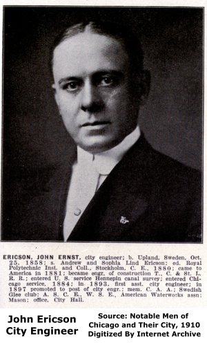
City Plaque CARTER H. HARRISON - MAYORL. E. MCGANN COMMISSIONER OF PUBLIC WORKS JOS. O. KOSTNER DEPUTY COMMISSIONER OF PUBLIC WORKS. JOHN ERICSON, CITY ENGINEER. THO'S. G. PIHLFELDT ENGINEER OF BRIDGES AND HARBOR. A. VON BABO, ENG'R. OF BRIDGE DESIGN. |
Builder Plaque SUPERSTRUCTURE BUILT BYTHE KETLER ELLIOTT ERECTION CO. CHICAGO, ILL. 1914 SUBSTRUCTURE BUILT BY BRYNE BROS. DRED'G. AND ENG'G. CO. CHICAGO ILL. |
![]()
Historic Bridges of Chicago and Cook County


Chicago and Cook County are home to one of the largest collections of historic bridges in the country, and no other city in the world has more movable bridges. HistoricBridges.org is proud to offer the most extensive coverage of historic Chicago bridges on the Internet.
General Chicago / Cook County Bridge Resources
Chicago's Bridges - By Nathan Holth, author of HistoricBridges.org, this book provides a discussion of the history of Chicago's movable bridges, and includes a virtual tour discussing all movable bridges remaining in Chicago today. Despite this broad coverage, the book is presented in a compact format that is easy to take with you and carry around for reference on a visit to Chicago. The book includes dozens of full color photos. Only $9.95 U.S! ($11.95 Canadian). Order Now Direct From The Publisher! or order on Amazon.
Chicago River Bridges - By Patrick T. McBriarty, this is a great companion to Holth's book shown above. This much larger book offers an extremely in-depth exploration of Chicago's movable highway bridges, including many crossings that have not existed for many years. Order Now Direct From The Publisher! or order on Amazon.
View Historic American Engineering Record (HAER) Overview of Chicago Bascule Bridges (HAER Data Pages, PDF)
Chicago Loop Bridges - Chicago Loop Bridges is another website on the Internet that is a great companion to the HistoricBridges.org coverage of the 18 movable bridges within the Chicago Loop. This website includes additional information such as connections to popular culture, overview discussions and essays about Chicago's movable bridges, additional videos, and current news and events relating to the bridges.
Additional Online Articles and Resources - This page is a large gathering of interesting articles and resources that HistoricBridges.org has uncovered during research, but which were not specific to a particular bridge listing.
![]()
Photo Galleries and Videos: Chicago Avenue Bridge
Bridge Photo-Documentation
Original / Full Size PhotosA collection of overview and detail photos. This gallery offers photos in the highest available resolution and file size in a touch-friendly popup viewer.
Alternatively, Browse Without Using Viewer
![]()
Bridge Photo-Documentation
Mobile Optimized PhotosA collection of overview and detail photos. This gallery features data-friendly, fast-loading photos in a touch-friendly popup viewer.
Alternatively, Browse Without Using Viewer
![]()
Bumpercam: Westbound Crossing
Full Motion VideoNote: The downloadable high quality version of this video (available on the video page) is well worth the download since it offers excellent 1080 HD detail and is vastly more impressive than the compressed streaming video. Streaming video of the bridge. Also includes a higher quality downloadable video for greater clarity or offline viewing.
![]()
Maps and Links: Chicago Avenue Bridge
This historic bridge has been demolished. This map is shown for reference purposes only.
Coordinates (Latitude, Longitude):
Search For Additional Bridge Listings:
Bridgehunter.com: View listed bridges within 0.5 miles (0.8 kilometers) of this bridge.
Bridgehunter.com: View listed bridges within 10 miles (16 kilometers) of this bridge.
Additional Maps:
Google Streetview (If Available)
GeoHack (Additional Links and Coordinates)
Apple Maps (Via DuckDuckGo Search)
Apple Maps (Apple devices only)
Android: Open Location In Your Map or GPS App
Flickr Gallery (Find Nearby Photos)
Wikimedia Commons (Find Nearby Photos)
Directions Via Sygic For Android
Directions Via Sygic For iOS and Android Dolphin Browser
USGS National Map (United States Only)
Historical USGS Topo Maps (United States Only)
Historic Aerials (United States Only)
CalTopo Maps (United States Only)

