

View Information About HSR Ratings
Lengths given are estimates.
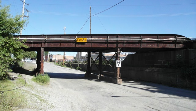
Albert David provided the following information:
According to the Images of America series book Summit, by Robert Kott, this bridge was built in 1903. The bridge was constructed as a joint effort of the Chicago and Alton Railroad and the Chicago & Joliet Electric Railway to eliminate the need for a flagman at the location. The sidewalks and railings in the pictures appear to be original. The center lane, which is currently the one used for vehicle traffic, was originally used by streetcars of the Chicago & Joliet Electric Railway.
The road that this bridge crosses was once a major thoroughfare through the area. The road was called Lincoln Avenue in this area, while it was called Lawndale Avenue further north. The street sign at the intersection with Center Avenue now reads both Lawndale and Lincoln, though Lawndale is now the official name. When I-55 was built in 1964, the road was disconnected from the portion of Lawndale north of I-55. Lawndale/Lincoln is now essentially only used by the local businesses in the area, and the bridge has seen little to no maintenance.
A swing bridge built in 1899 carried Lincoln over the Chicago Sanitary and Shipping canal, but this bridge was torn down when I-55 was constructed.
This bridge is tagged with the following special condition(s): Unorganized Photos
![]()
![]()
![]()
Coordinates (Latitude, Longitude):
Search For Additional Bridge Listings:
Bridgehunter.com: View listed bridges within 0.5 miles (0.8 kilometers) of this bridge.
Bridgehunter.com: View listed bridges within 10 miles (16 kilometers) of this bridge.
Additional Maps:
Google Streetview (If Available)
GeoHack (Additional Links and Coordinates)
Apple Maps (Via DuckDuckGo Search)
Apple Maps (Apple devices only)
Android: Open Location In Your Map or GPS App
Flickr Gallery (Find Nearby Photos)
Wikimedia Commons (Find Nearby Photos)
Directions Via Sygic For Android
Directions Via Sygic For iOS and Android Dolphin Browser
USGS National Map (United States Only)
Historical USGS Topo Maps (United States Only)
Historic Aerials (United States Only)
CalTopo Maps (United States Only)

© Copyright 2003-2024, HistoricBridges.org. All Rights Reserved. Disclaimer: HistoricBridges.org is a volunteer group of private citizens. HistoricBridges.org is NOT a government agency, does not represent or work with any governmental agencies, nor is it in any way associated with any government agency or any non-profit organization. While we strive for accuracy in our factual content, HistoricBridges.org offers no guarantee of accuracy. Information is provided "as is" without warranty of any kind, either expressed or implied. Information could include technical inaccuracies or errors of omission. Opinions and commentary are the opinions of the respective HistoricBridges.org member who made them and do not necessarily represent the views of anyone else, including any outside photographers whose images may appear on the page in which the commentary appears. HistoricBridges.org does not bear any responsibility for any consequences resulting from the use of this or any other HistoricBridges.org information. Owners and users of bridges have the responsibility of correctly following all applicable laws, rules, and regulations, regardless of any HistoricBridges.org information.
![]()