We Recommend:
Bach Steel - Experts at historic truss bridge restoration.
Ford City Drive Bridge
Keller Drive Bridge

Primary Photographer(s): Nathan Holth
Bridge Documented: September 8, 2011
Chicago: Cook County, Illinois: United States
Not Available or Not Applicable
83.0 Feet (25.3 Meters)
90.0 Feet (27.4 Meters)
48 Feet (14.63 Meters)
1 Main Span(s)
16075022211

View Information About HSR Ratings
Bridge Documentation
This bridge no longer exists!
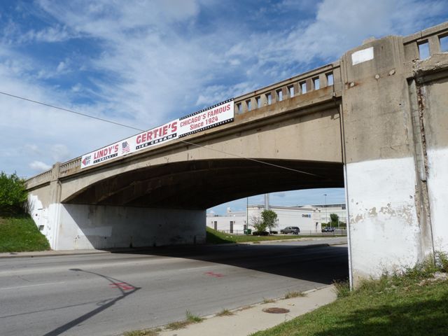
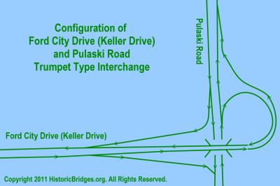
Bridge Status: Demolished in 2020.This bridge is a concrete rigid-frame bridge. Among concrete rigid-frame bridges it is somewhat unusual since it has a ribbed design that shows distinctive concrete beams making it look like a curved t-beam bridge. Retaining original railings, this bridge stands out technologically as a relatively large span and unaltered concrete rigid frame. The only alteration appears to have been the in-kind replacement of the concrete deck. The bridge and associated roadway is part of a trumpet type interchange with Pulaski Road.
This bridge was highlighted as eligible for listing in the National Register of Historic Places by the Illinois Historic Bridge Inventory (HBI). The Illinois HBI is one of the least useful inventories in the country because despite repeated attempts to secure data from the state department of transportation all that appears to exist for Illinois is a list of which bridges are considered eligible. No justification and explanation for the eligibility determinations appears to be available. This means that the history of the bridge and why it is considered eligible is not officially known. However it is likely that the bridge is eligible under Criterion A for association with important events, that being the World War II related effort of constructing the massive Dodge Chicago Plant which was an enormous factory that was constructed to facilitate production of bombers for the war effort. Chicago's efforts to build such a plant are similar to efforts in the Detroit, Michigan area to construct the Willow Run bomber plant. Like the Willow Run plant, the Dodge Chicago plant was established in a lightly populated area where the space was available for the plant. Like the interchanges and expressways constructed at Michigan's Willow Run, the construction of the overpass and associated interchange with Pulaski Road undoubtedly was created to help efficiently deal with the massive amount of traffic that would have been generated from work shift changes and other activity at the plant.
Portions of the Dodge Chicago Plant remain today as the Ford City Mall and some of the other buildings also remain in the area.
The bridge and interchange may also be eligible for listing in the National Register of Historic Places under Criterion C as an early and complete example of an interchange system.
The divided highway that the bridge carries starts at Pulaski Road and continues west. Today, it ends and makes a 90 degree turn onto Kostner Avenue. However the divided highway once continued west from this point, connecting with Cicero Avenue. There appears to have been an additional interchange at Cicero Avenue that does not remain today, with the exception of two of the ramps which today appear to serve as an entrance into the Ford City Mall.
![]()
Photo Galleries and Videos: Ford City Drive Bridge
Bridge Photo-Documentation
Original / Full Size PhotosA collection of overview and detail photos. This gallery offers photos in the highest available resolution and file size in a touch-friendly popup viewer.
Alternatively, Browse Without Using Viewer
![]()
Bridge Photo-Documentation
Mobile Optimized PhotosA collection of overview and detail photos. This gallery features data-friendly, fast-loading photos in a touch-friendly popup viewer.
Alternatively, Browse Without Using Viewer
![]()
Maps and Links: Ford City Drive Bridge
This historic bridge has been demolished. This map is shown for reference purposes only.
Coordinates (Latitude, Longitude):
Search For Additional Bridge Listings:
Bridgehunter.com: View listed bridges within 0.5 miles (0.8 kilometers) of this bridge.
Bridgehunter.com: View listed bridges within 10 miles (16 kilometers) of this bridge.
Additional Maps:
Google Streetview (If Available)
GeoHack (Additional Links and Coordinates)
Apple Maps (Via DuckDuckGo Search)
Apple Maps (Apple devices only)
Android: Open Location In Your Map or GPS App
Flickr Gallery (Find Nearby Photos)
Wikimedia Commons (Find Nearby Photos)
Directions Via Sygic For Android
Directions Via Sygic For iOS and Android Dolphin Browser
USGS National Map (United States Only)
Historical USGS Topo Maps (United States Only)
Historic Aerials (United States Only)
CalTopo Maps (United States Only)


