

View Information About HSR Ratings

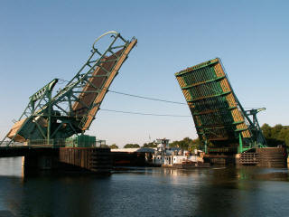
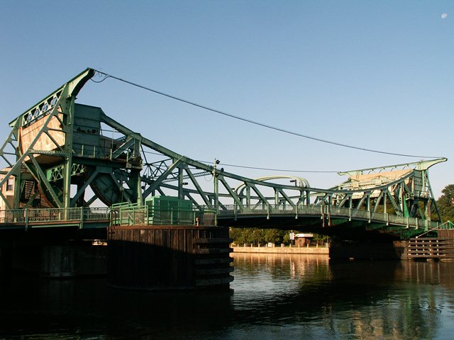
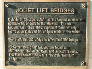
Chicago may be the bascule bridge capital of the world, but no tour of bascule bridges is complete without a trip down to Joliet, where the Scherzer rolling lift bascule bridge outnumbers the Chicago trunnion style bascule bridge. There are four Scherzer rolling lift style highway bridges in Joliet, whereas the Chicago only contributes one highway example which has also suffered from loss of original bridge material. Of these four examples in Joliet, they can be grouped into two general styles, those with wide decks such as the Jefferson Street Bridge and those with narrower decks such as the McDonough Street Bridge. Also, ironically, Joliet picked the Jefferson Street Bridge to place a small informative plaque discussing their bridges. These plaques were placed with the revitalization of the downtown area that has taken place over the last 10-15 years. It was probably was chosen to bear the plaque because it's a bit more accessible to pedestrians than the nearby Cass Street Bridge and other structures in town.
It is also worth noting that replacing these beautiful bridges in Joliet is discussed occasionally. Nothing has ever come of it however. It is imperative that nothing ever comes of it, as these structures are all historically significant and worthy of preservation.

These bridges have a similar truss design with double truss leaves that cantilever out to the center of the channel. The trusses follow a Pratt configuration. In this sense, they are similar to the trunnion bridges of downtown Chicago like the Clark Street Bridge in that the trusses have that unusual "U" shape that you see when these bridges are in the closed position. The rolling lift bascule bridges in Joliet differ visually from the trunnion bascules in Chicago in that the trusses are taller, and lead up to an overhead concrete counterweight that is present above the roadway rather than hidden below in a counterweight pit. These counterweights are held stable on the bridge via trussed towers. The key feature of the rolling lift bascule is the use of a roller and track upon which the bridge rolls to open rather than rotating around an axel as a trunnion bascule bridge does. The rolling lift action is very visible on these bridges, and you can easily see the part that the bridge rolls on directly below the counterweight. These bridges have unusual cantilevered plates of steel that hold electrical wires and allow them to span across the river above the bridge. This design limits the height of boats that can pass under the bridge. This was not an issue as the taller Great Lakes freighters and tall sailboats never came down this section of river. Most of the bascule bridges in Joliet have beautiful overhead arches that appear at the center of the bridge and at the approach to the bridge. These were for cable-cars/trolleys that once would have crossed the bridge. Chicago's bascule bridges once had supports for this purpose but they have all been removed. These supports remain in place here in Joliet, a testimony to a long-lost type of transportation in this region.

With riveted, built-up beams on the bascule bridges, v-lacing and lattice can be found on select parts of the bridges. Connections on the bridge are all riveted. The bridge-tenders houses are original, and are not as fancy and ornate as the downtown Chicago bridges, but are still tastefully designed to look nice. The bridges retain original railings that have a decorative design to them. These bridges continue to operate for boats, mostly barges, as needed.
![]()
![]()
![]()
Coordinates (Latitude, Longitude):
Search For Additional Bridge Listings:
Bridgehunter.com: View listed bridges within 0.5 miles (0.8 kilometers) of this bridge.
Bridgehunter.com: View listed bridges within 10 miles (16 kilometers) of this bridge.
Additional Maps:
Google Streetview (If Available)
GeoHack (Additional Links and Coordinates)
Apple Maps (Via DuckDuckGo Search)
Apple Maps (Apple devices only)
Android: Open Location In Your Map or GPS App
Flickr Gallery (Find Nearby Photos)
Wikimedia Commons (Find Nearby Photos)
Directions Via Sygic For Android
Directions Via Sygic For iOS and Android Dolphin Browser
USGS National Map (United States Only)
Historical USGS Topo Maps (United States Only)
Historic Aerials (United States Only)
CalTopo Maps (United States Only)

© Copyright 2003-2025, HistoricBridges.org. All Rights Reserved. Disclaimer: HistoricBridges.org is a volunteer group of private citizens. HistoricBridges.org is NOT a government agency, does not represent or work with any governmental agencies, nor is it in any way associated with any government agency or any non-profit organization. While we strive for accuracy in our factual content, HistoricBridges.org offers no guarantee of accuracy. Information is provided "as is" without warranty of any kind, either expressed or implied. Information could include technical inaccuracies or errors of omission. Opinions and commentary are the opinions of the respective HistoricBridges.org member who made them and do not necessarily represent the views of anyone else, including any outside photographers whose images may appear on the page in which the commentary appears. HistoricBridges.org does not bear any responsibility for any consequences resulting from the use of this or any other HistoricBridges.org information. Owners and users of bridges have the responsibility of correctly following all applicable laws, rules, and regulations, regardless of any HistoricBridges.org information.
![]()