

View Information About HSR Ratings
Additional Information: This bridge may have been built by P.E. Lane of Chicago, Illinois based on the design of the portal bracing and the fact that it is located in Illinois. However this is not proven and is only an estimate.
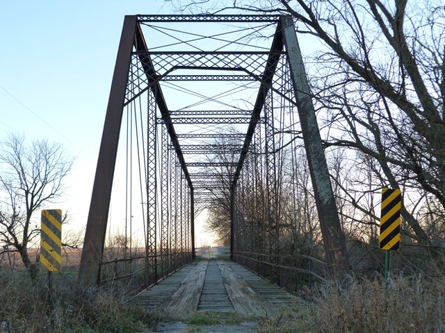
As of November 2024, the road commissioner in Maine Township, Grundy County contacted HistoricBridges.org and warns that "the wood bridge decking has rotted to the point where walking on it is extremely dangerous."
This is a highly significant historic bridge. With a clear span length of 170 feet, this bridge is an extremely long span example of a pin-connected Pratt truss. Spans of this length were more often configured as double-intersection Pratt (Whipple) truss spans, but this bridge maintains a single intersection Pratt design. With an 1884 construction date, this is also an early surviving example of a pin-connected truss bridge. The bridge is also noted for its lack of alteration. There are little alterations to the bridge. The most obvious alteration was some bolted repairs to one damaged vertical member. The bridge appears to be wrought iron. Frustratingly, the builder of this bridge is unknown.
The bridge is closed to traffic but from a restoration viewpoint, is in good condition and could easily be restored. Even in its current unrestored condition, the bridge does not appear to be at risk for collapse. Overall, there is little deterioration on the bridge. In particular, there is hardly any section loss on the members at the bottom chord connections, which is a traditional location for the worst deterioration on a truss bridge.
![]()
![]()
![]()
Coordinates (Latitude, Longitude):
Search For Additional Bridge Listings:
Bridgehunter.com: View listed bridges within 0.5 miles (0.8 kilometers) of this bridge.
Bridgehunter.com: View listed bridges within 10 miles (16 kilometers) of this bridge.
Additional Maps:
Google Streetview (If Available)
GeoHack (Additional Links and Coordinates)
Apple Maps (Via DuckDuckGo Search)
Apple Maps (Apple devices only)
Android: Open Location In Your Map or GPS App
Flickr Gallery (Find Nearby Photos)
Wikimedia Commons (Find Nearby Photos)
Directions Via Sygic For Android
Directions Via Sygic For iOS and Android Dolphin Browser
USGS National Map (United States Only)
Historical USGS Topo Maps (United States Only)
Historic Aerials (United States Only)
CalTopo Maps (United States Only)

© Copyright 2003-2024, HistoricBridges.org. All Rights Reserved. Disclaimer: HistoricBridges.org is a volunteer group of private citizens. HistoricBridges.org is NOT a government agency, does not represent or work with any governmental agencies, nor is it in any way associated with any government agency or any non-profit organization. While we strive for accuracy in our factual content, HistoricBridges.org offers no guarantee of accuracy. Information is provided "as is" without warranty of any kind, either expressed or implied. Information could include technical inaccuracies or errors of omission. Opinions and commentary are the opinions of the respective HistoricBridges.org member who made them and do not necessarily represent the views of anyone else, including any outside photographers whose images may appear on the page in which the commentary appears. HistoricBridges.org does not bear any responsibility for any consequences resulting from the use of this or any other HistoricBridges.org information. Owners and users of bridges have the responsibility of correctly following all applicable laws, rules, and regulations, regardless of any HistoricBridges.org information.
![]()