

View Information About HSR Ratings
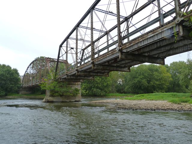
This abandoned bridge which is closed to all traffic carried Division Street over Des Plaines River. At one time an additional bridge, a swing bridge which is today gone, would have carried the street over the Sanitary and Ship Canal to the east as well. This bridge was reportedly closed in 1993 when a high level bridge was constructed for IL-7 about three quarters of a mile north of this bridge. Historical photos of the Division Street Bridge can be found in this book. Today, the bridge is abandoned at the eastern end of the Lockport Prairie Nature Preserve. The bridge itself however appears to be owned or managed by the Metropolitan Water Reclamation District of Greater Chicago, the state agency that manages the Sanitary and Ship Canal.
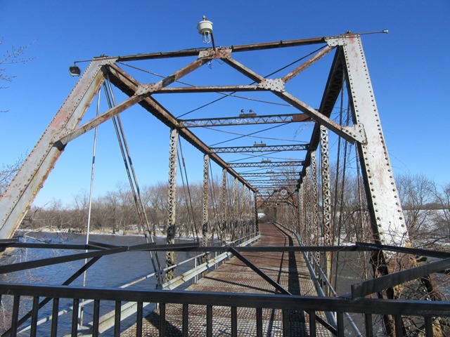
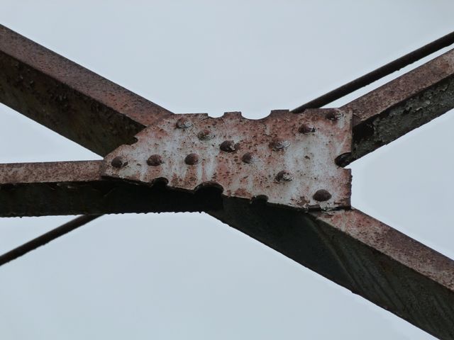
This bridge is regionally rare as an example of a pin-connected truss bridge. It is significant both regionally and on a statewide level as an example of a multi-span truss bridge. The construction date is listed as ca. 1899 by Will County, who listed the bridge on a county register of historic places in 1995. Unsurprising for a bridge built during this late pin-connected period, the bridge has floorbeams that are riveted to the vertical members directly, rather than using the older method of u-bolt hangers. This bridge is unusual because it has two nine panel Parker truss spans but the third span is a nine panel Pratt truss. The western span is the Pratt span. Another unusual feature is that the roadway is not straight on the bridge; the bridge makes a turn at the pier that supports the Pratt truss and the western Parker truss span to accommodate this feature. The builder of the bridge is not known, and a detailed history of the bridge's construction is not known. There are some unusual aspects of the bridge to note. The composition of the Pratt truss is stylistically different from the Parker truss spans. The Parker truss has vertical members with v-lacing bars that each have their own two dedicated rivets. This is more common on railroad truss bridges, while highway truss bridges generally share rivets between two bars. The Pratt truss displays the shared rivet design, and the lacing design is also more tight. The Pratt truss has a very unusual, apparently decorative, detail where the gusset plates for the connections on the portal bracing have half circle cutouts on the edge of the gussets. The Parker truss does not display this, but the Parker truss has Portal bracing knees with an attractive curved design and inside that are decorative triangular cutouts, a detail not found on the Pratt. The Parker also has v-lacing on the top of the end post and top chord, an uncommon detail, while the Pratt has a much more typical cover plate on top. Finally, the Pratt truss has bottom chord connections that show a greater level of deterioration than the Parker truss spans with significant levels of pack rust present between the eyebars. Overall, the physical condition of the bridge is such that it would be feasible and cost-effective to restore the truss for non-motorized use. Aside from the bottom chord connection deterioration, the overall condition of the bridge is not bad for an abandoned bridge.
Above: February 2022 view of bridge. Photo Credit: Kevin Coyote-Trust
![]()
![]()
![]()
![]()
![]()
This bridge is closed to all traffic. It can be reached by approaching from the West.
Coordinates (Latitude, Longitude):
Search For Additional Bridge Listings:
Bridgehunter.com: View listed bridges within 0.5 miles (0.8 kilometers) of this bridge.
Bridgehunter.com: View listed bridges within 10 miles (16 kilometers) of this bridge.
Additional Maps:
Google Streetview (If Available)
GeoHack (Additional Links and Coordinates)
Apple Maps (Via DuckDuckGo Search)
Apple Maps (Apple devices only)
Android: Open Location In Your Map or GPS App
Flickr Gallery (Find Nearby Photos)
Wikimedia Commons (Find Nearby Photos)
Directions Via Sygic For Android
Directions Via Sygic For iOS and Android Dolphin Browser
USGS National Map (United States Only)
Historical USGS Topo Maps (United States Only)
Historic Aerials (United States Only)
CalTopo Maps (United States Only)

© Copyright 2003-2024, HistoricBridges.org. All Rights Reserved. Disclaimer: HistoricBridges.org is a volunteer group of private citizens. HistoricBridges.org is NOT a government agency, does not represent or work with any governmental agencies, nor is it in any way associated with any government agency or any non-profit organization. While we strive for accuracy in our factual content, HistoricBridges.org offers no guarantee of accuracy. Information is provided "as is" without warranty of any kind, either expressed or implied. Information could include technical inaccuracies or errors of omission. Opinions and commentary are the opinions of the respective HistoricBridges.org member who made them and do not necessarily represent the views of anyone else, including any outside photographers whose images may appear on the page in which the commentary appears. HistoricBridges.org does not bear any responsibility for any consequences resulting from the use of this or any other HistoricBridges.org information. Owners and users of bridges have the responsibility of correctly following all applicable laws, rules, and regulations, regardless of any HistoricBridges.org information.
![]()