

View Information About HSR Ratings
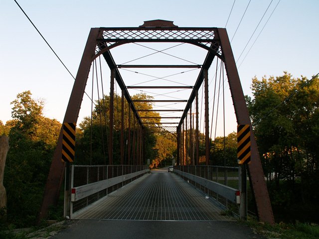
This classic bridge seems out of place in Will County, which along with Cook County is an area known for truss bridges with massive-members and mostly built in the 20th Century, and mostly movable bridges. Finding a classic pin connected Pratt through truss constructed by the Wrought Iron Bridge Company of Canton, Ohio is the last thing you might expect. Yet here it sits, open to traffic in an area that is really not that far from a commercialized suburban area. As such, it is particularly rare and significant in a local context.
This bridge has an original builder plaque on it, and while it looks nice and allows visitors to identify who built the bridge, like a number of the Wrought Iron Bridge Company plaques, it falls short of providing one of the most valuable pieces of information - a construction date! The Historic American Engineering Record (HAER) simply remarks that the accepted date is 1912, but that statement only calls the competency of the historian who compiled the HAER report into question. It is common knowledge among bridge historians that Wrought Iron Bridge Company was absorbed into the American Bridge Company in 1900 bringing an end to the company name.
The bridge is traditionally designed, and features v-lacing on the verticals and under the top chord / end posts. The portal bracing is a lattice design. The bridge is seated on stone abutments. There are nine panels composing the structure.
This bridge is to be replaced with a new bridge on different alignment, but reportedly will be preserved in place for pedestrian use, which is a good outcome that will save this historic bridge and keep it around for many decades to come.
![]()
![]()
![]()
Coordinates (Latitude, Longitude):
Search For Additional Bridge Listings:
Bridgehunter.com: View listed bridges within 0.5 miles (0.8 kilometers) of this bridge.
Bridgehunter.com: View listed bridges within 10 miles (16 kilometers) of this bridge.
Additional Maps:
Google Streetview (If Available)
GeoHack (Additional Links and Coordinates)
Apple Maps (Via DuckDuckGo Search)
Apple Maps (Apple devices only)
Android: Open Location In Your Map or GPS App
Flickr Gallery (Find Nearby Photos)
Wikimedia Commons (Find Nearby Photos)
Directions Via Sygic For Android
Directions Via Sygic For iOS and Android Dolphin Browser
USGS National Map (United States Only)
Historical USGS Topo Maps (United States Only)
Historic Aerials (United States Only)
CalTopo Maps (United States Only)

© Copyright 2003-2024, HistoricBridges.org. All Rights Reserved. Disclaimer: HistoricBridges.org is a volunteer group of private citizens. HistoricBridges.org is NOT a government agency, does not represent or work with any governmental agencies, nor is it in any way associated with any government agency or any non-profit organization. While we strive for accuracy in our factual content, HistoricBridges.org offers no guarantee of accuracy. Information is provided "as is" without warranty of any kind, either expressed or implied. Information could include technical inaccuracies or errors of omission. Opinions and commentary are the opinions of the respective HistoricBridges.org member who made them and do not necessarily represent the views of anyone else, including any outside photographers whose images may appear on the page in which the commentary appears. HistoricBridges.org does not bear any responsibility for any consequences resulting from the use of this or any other HistoricBridges.org information. Owners and users of bridges have the responsibility of correctly following all applicable laws, rules, and regulations, regardless of any HistoricBridges.org information.
![]()