

View Information About HSR Ratings
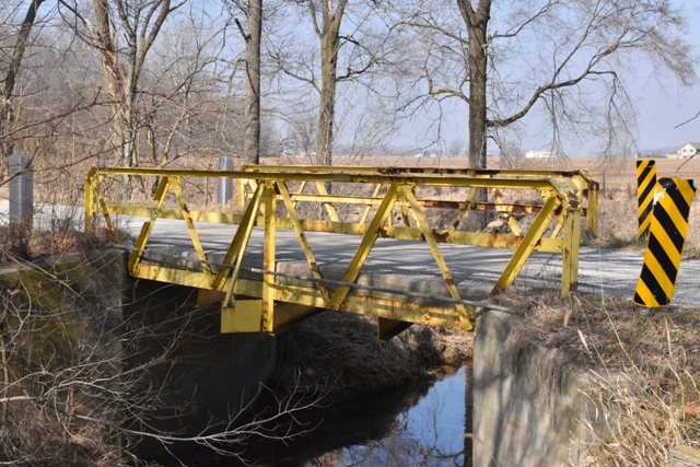
This is a very small and unusual skewed pony truss bridge with very lightweight truss members. It has some alterations and repairs made to it. It has a 45 degree skew.
Information and Findings From DHPA Historic Bridge SurveyStatement of Significance About two-thirds of the south truss of this largely-riveted Warren pony is offset to the east. Given their low horizontal profile, the vertical end-posts are set behind and encased in the concrete abutments. The members are light, even for a pony truss. A pair of angles riveted together comprise the end-posts and top chord; a single provides the diagonals. The single vertical--a simple angle placed at mid-span--is bolted to a gusset at the top panel point along with a pair of diagonals and passes through the lower chord to the I floor-beam below. A sway-brace connected to the upper panel point with the vertical is bolted to a plate extended beyond the floor-beam to help stiffen the truss. The floor-beam helps to carry the runs of stringers above along with the concrete roadway. This unusual truss-beam hybrid seems to have retained most of its original members although in a new orientation. It is unusual for at least two reasons. First, load is significantly shared between the stringers and the trusses through the floor-beam and the lower mid-span panel point. Second, there are six lower panel points but only one floor-beam. The structure may have been designed and originally erected for a non-skewed crossing. Very few of these light pony trusses have survived in Indiana. Other Information References Charles J. Ritzler, Bridge Inspection Report: Carroll County (Delphi, 1974-75). Rumschlag Technical Services, Carroll County Bridge Inventory & Appraisal Report (Brownsburg, 2006). Bridge Considered Historic By Survey: Yes |
![]()
![]()
![]()
Coordinates (Latitude, Longitude):
Search For Additional Bridge Listings:
Bridgehunter.com: View listed bridges within 0.5 miles (0.8 kilometers) of this bridge.
Bridgehunter.com: View listed bridges within 10 miles (16 kilometers) of this bridge.
Additional Maps:
Google Streetview (If Available)
GeoHack (Additional Links and Coordinates)
Apple Maps (Via DuckDuckGo Search)
Apple Maps (Apple devices only)
Android: Open Location In Your Map or GPS App
Flickr Gallery (Find Nearby Photos)
Wikimedia Commons (Find Nearby Photos)
Directions Via Sygic For Android
Directions Via Sygic For iOS and Android Dolphin Browser
USGS National Map (United States Only)
Historical USGS Topo Maps (United States Only)
Historic Aerials (United States Only)
CalTopo Maps (United States Only)

© Copyright 2003-2026, HistoricBridges.org. All Rights Reserved. Disclaimer: HistoricBridges.org is a volunteer group of private citizens. HistoricBridges.org is NOT a government agency, does not represent or work with any governmental agencies, nor is it in any way associated with any government agency or any non-profit organization. While we strive for accuracy in our factual content, HistoricBridges.org offers no guarantee of accuracy. Information is provided "as is" without warranty of any kind, either expressed or implied. Information could include technical inaccuracies or errors of omission. Opinions and commentary are the opinions of the respective HistoricBridges.org member who made them and do not necessarily represent the views of anyone else, including any outside photographers whose images may appear on the page in which the commentary appears. HistoricBridges.org does not bear any responsibility for any consequences resulting from the use of this or any other HistoricBridges.org information. Owners and users of bridges have the responsibility of correctly following all applicable laws, rules, and regulations, regardless of any HistoricBridges.org information.
![]()