

View Information About HSR Ratings
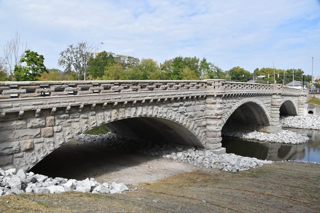
This modern bridge is not historic, but it reused some of the stone from the previous historic bridge which dated to 1900, and displays a similar railing and spandrel appearance. The builder shown above, Gansburg, Roney and Heywood, refers to the builder of the 1900 bridge. This modern bridge is mainly included on this website for the sake of explanation. The bridge was considered a "Select" bridge under the Indiana Historic Bridge Management Plan which meant the bridge should have been preserved, yet the owner found a way around this and demolished and replaced the bridge. This is now a modern concrete arch bridge, with a stone fascia composed of a modern stone arch ring, and salvaged stones from the historic bridge placed atop of the modern arch ring forming the spandrel wall. The railings are also salvaged stone. In summary, the only thing original on this bridge is some of the railing and spandrel wall.
Information and Findings From DHPA Historic Bridge SurveyHistory of 1900 Bridge For a previous structure at this site, see Marion Co., Bruce Ford {49-1804}. The construction of a new bridge on Central Avenue was "much-talked-of" in 1899. There was some interest in a "City Beautiful" stone structure, but cost remained central to the Marion County Commissioners. At the outset, two commissioners (Greer and Harding) favored construction of "a steel girder bridge" because they thought a steel design would cost the county less to build than a stone one. McGregor "maintained that a stone bridge was the only suitable structure to be built". Both the city engineer and the county surveyor had submitted plans to the commissioners for a plate girder bridge for Central Avenue over Fall Creek. In early August, the county received some 15 bids on a variety of plans. Five were for stone; ten for steel. When the bids were considered, the commissioners were surprised to find that Gansburg, Roney & Heywood had brought in the lowest bid -- by $7,443 -- at $36,757 to build an unusual and possibly unique design. Their "Melan arch stone bridge" proposal consisted of steel ribs apparently "reinforced" with sandstone -- a format borrowed from concrete "reinforced" filled-spandrel structures. The unusual proposal was apparently designed in part to address an "objection" that "the arches of a standard-design stone arch bridge would have to be constructed too lightly at the top, and might be easily thrown out of place by a heavy streetcar passing over them." The commissioners awarded a contract to Gansburg, Roney & Heywood at the end of August for their special design which had been vetted by the county engineer, John V. Coyner. Construction proceeded through the rest of 1899 and into 1900, with final payments to the contractors and the construction engineer, Coyner, in August 1900. Each of the filled-spandrel rings is segmental. Spandrels, projected and rounded piers, parapet rails, and refuge-bays are of limestone and the rings of sandstone. This may be the oldest "reinforced" arch structure in the state. If, by "Melan arch stone bridge," the designers meant what is described above as steel ribs supported by stone and not concrete with stone-facing, it seems to be unique in Indiana and is rare if not also nationally one-of-a-kind. Stephen Weintraut, P.E. of Butler, Fairman & Seufert Engineers, reported (July 2012) that the North span had steel ribs added in the 1950s with the ribs and the extrados of the ring then covered with gunnite. The extrados of the other two spans were also encased with gunnite at the same time. Weintraut also reported that the encasement has caused considerable damage to the ring stone. References United Consulting Engineers, Bridge Inspection Study and Report: City of Indianapolis (Indianapolis, 1975). Floyd E. Burroughs & Associates, Bridge Reinspection: Marion County (Indianapolis, 1988). Stephen J. Christian & Associates, Marion County: Bridge Inspection Report (Indianapolis, 2008). bridge plate. "Contract Not Awarded," "It Will Be of Stone," Indianapolis Journal,1 August 1899: 8; 31 August 1899: p8c3. "Supplement," Engineering News & American Railway Journal, XLII (7 September 1899): 76. Marion County, "Commissioners Record," 34: 13, 37, 116, 118, 150, 185, 188, 211, 218, 233, 365-366. History of 1872 Bridge Marion County Location In August 1872, the Marion County Commissioners had contracted the Massillon Bridge Company of Massillon, Ohio, to build the Bruce Ford Bridge for $19.75 per lineal foot or $3,950 for the whole. The bridge's designer was Joseph Davenport, owner of the Massillon Bridge Company. Born in Massachusetts in 1815, Davenport became an avid inventor, building the first American-made passenger cars for railroads and designing the first cow catcher and enclosed cab for locomotives. Arriving in Massillon in 1850, Davenport designed and built bridges in both wood and iron. In 1867 and 1868, he patented an iron, arched "bridge-girder" equivalent of William Howe's wooden truss of the 1840s. In 1873, Davenport incorporated the Massillon Bridge Company for building wooden structures and the Massillon Iron Bridge Company for metal spans. The main span is a 93' bowstring arch pony consisted of twelve panels separated by cruciform-shaped verticals bolted through both plates of the arch, to the floor beam, and between the lower chord plates. Cylindrical eyebars crossed all except the end-post panels and are bolted through the lower arch plate and between the lower chord plates as diagonals. The arch consisted of bolted sections of parallel curved plates with latticed iron columns (two angled downward, one upward) fitted into cast iron seats and the whole being secured with a pair of adjustable cylindrical rods running through the arch plates and cast iron seats. A pair of die-forged rectangular bars served as the lower chord. Placed above and U-bolted to the lower chord, I floor-beams (many added to the original ones) carried the timber deck and roadway. Every other original floor beam extended beyond the lower chord to accommodate a cruciform-shaped stabilizer which is attached to a vertical above. On May 12, 1899, the twin span had collapsed under the weight of a sand-laden street railway car. Morgan County Locations The Sheerer Bridge, an early 1860s Zenas King patented bowstring-arch bridge over Indian Creek on the Martinsville-Bloomington Road, was reported on December 4, 1899 to be "in a dangerous condition." A replacement bridge was to be erected by January 1, 1900, and the county issued a contract for the replacement to the Indianapolis Bridge Company and Iron Works with one-half of the original two-span, wrought iron Davenport Howe truss bridge originally found on Central Avenue over Fall Creek in Marion County. The south span of the Bruce Ford Bridge was relocated in December 1899 to Indian Creek on the Martinsville-Bloomington Road. The Sheerer Bridge, as it became known, was incorporated as a part of Indiana State Highway #22 (now old State Road #37) in 1919. In 1925 the Sheerer Bridge was relocated for a second time to Burton Lane. For details on the Sheerer and Burton Lane Bridges, see same under Morgan County #42. For successor structures on Central Avenue in Indianapolis, see Marion Co. #1804. References Marion County, "Commissioners Record", 11, 12, 32, and 33. James L.Cooper, "The Historian as Detective: The Case of the Burton Lane Bridge," 1992. David A. Simmons, "The Davenport Truss," Timeline (Feb.-Mar.), 18; "Two Ohio Structures Represent Earliest Period of Iron Bridges," Ohio County Engineers News (May), 12-13. Ohio Department of Transportation, Ohio Historic Bridge Inventory Evaluation, and Preservation Plan (Columbus, 1983), 9, 202, and 205. Bridge Considered Historic By Survey: Yes |
![]()
![]()
![]()
Coordinates (Latitude, Longitude):
Search For Additional Bridge Listings:
Bridgehunter.com: View listed bridges within 0.5 miles (0.8 kilometers) of this bridge.
Bridgehunter.com: View listed bridges within 10 miles (16 kilometers) of this bridge.
Additional Maps:
Google Streetview (If Available)
GeoHack (Additional Links and Coordinates)
Apple Maps (Via DuckDuckGo Search)
Apple Maps (Apple devices only)
Android: Open Location In Your Map or GPS App
Flickr Gallery (Find Nearby Photos)
Wikimedia Commons (Find Nearby Photos)
Directions Via Sygic For Android
Directions Via Sygic For iOS and Android Dolphin Browser
USGS National Map (United States Only)
Historical USGS Topo Maps (United States Only)
Historic Aerials (United States Only)
CalTopo Maps (United States Only)

© Copyright 2003-2026, HistoricBridges.org. All Rights Reserved. Disclaimer: HistoricBridges.org is a volunteer group of private citizens. HistoricBridges.org is NOT a government agency, does not represent or work with any governmental agencies, nor is it in any way associated with any government agency or any non-profit organization. While we strive for accuracy in our factual content, HistoricBridges.org offers no guarantee of accuracy. Information is provided "as is" without warranty of any kind, either expressed or implied. Information could include technical inaccuracies or errors of omission. Opinions and commentary are the opinions of the respective HistoricBridges.org member who made them and do not necessarily represent the views of anyone else, including any outside photographers whose images may appear on the page in which the commentary appears. HistoricBridges.org does not bear any responsibility for any consequences resulting from the use of this or any other HistoricBridges.org information. Owners and users of bridges have the responsibility of correctly following all applicable laws, rules, and regulations, regardless of any HistoricBridges.org information.
![]()