

View Information About HSR Ratings
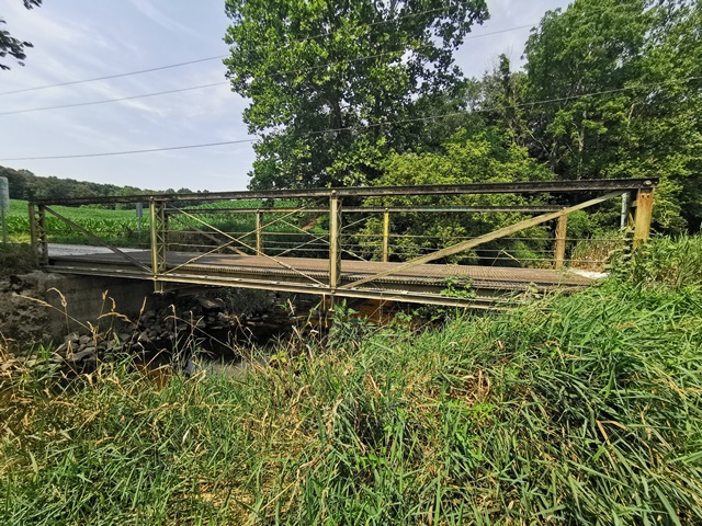
This is a rare example of a bedstead truss and also a rare example of a bridge by Brackett Bridge Company. The legs have been encased in replacement concrete abutments.
Information and Findings From DHPA Historic Bridge SurveyBridge History and Significance The Brackett Bridge Company of Cincinnati, Ohio, fabricated this pin-connected truss leg or Pratt bedstead pony which spans 45' in three panels. The truss legs run behind concrete abutments and wingwalls. The vertical endposts are fabricated of a pair of laced channels, the top chords of a pair of channels riveted together with a cover plate and battens, the interior verticals of a pair of laced channels, the outer diagonals of a pair of die-forged eyebars, the center panel's diagonal and counter of cylindrical rods with turnbuckles, and the lower chord of a pair of channels and battens. A pair of adjustable, cylindrical rods run from endpost to endpost between and parallel to the chords as horizontal struts. U-bolted to the pins, I floor-beams carry the timber deck with its roadway. The prolific Ohio firm departed from convention when it laced the endposts, made the lower chord uniformly rigid, and added horizontal struts to reduce the danger of buckling. The bridge retains its original structural integrity. References Bridge nameplate. American Consulting Engineers, Inc., Bridge Inspection/Reinspection Report: Martin County (Indianapolis, 1974, 1979). Bridge Considered Historic By Survey: Yes |
![]()
![]()
![]()
Coordinates (Latitude, Longitude):
Search For Additional Bridge Listings:
Bridgehunter.com: View listed bridges within 0.5 miles (0.8 kilometers) of this bridge.
Bridgehunter.com: View listed bridges within 10 miles (16 kilometers) of this bridge.
Additional Maps:
Google Streetview (If Available)
GeoHack (Additional Links and Coordinates)
Apple Maps (Via DuckDuckGo Search)
Apple Maps (Apple devices only)
Android: Open Location In Your Map or GPS App
Flickr Gallery (Find Nearby Photos)
Wikimedia Commons (Find Nearby Photos)
Directions Via Sygic For Android
Directions Via Sygic For iOS and Android Dolphin Browser
USGS National Map (United States Only)
Historical USGS Topo Maps (United States Only)
Historic Aerials (United States Only)
CalTopo Maps (United States Only)

© Copyright 2003-2026, HistoricBridges.org. All Rights Reserved. Disclaimer: HistoricBridges.org is a volunteer group of private citizens. HistoricBridges.org is NOT a government agency, does not represent or work with any governmental agencies, nor is it in any way associated with any government agency or any non-profit organization. While we strive for accuracy in our factual content, HistoricBridges.org offers no guarantee of accuracy. Information is provided "as is" without warranty of any kind, either expressed or implied. Information could include technical inaccuracies or errors of omission. Opinions and commentary are the opinions of the respective HistoricBridges.org member who made them and do not necessarily represent the views of anyone else, including any outside photographers whose images may appear on the page in which the commentary appears. HistoricBridges.org does not bear any responsibility for any consequences resulting from the use of this or any other HistoricBridges.org information. Owners and users of bridges have the responsibility of correctly following all applicable laws, rules, and regulations, regardless of any HistoricBridges.org information.
![]()