

View Information About HSR Ratings
Note: Above HAER documentation refers to a nearby and nearly identical bridge that was built under the same contract as the Shawnee Bridge.
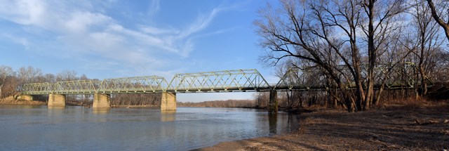
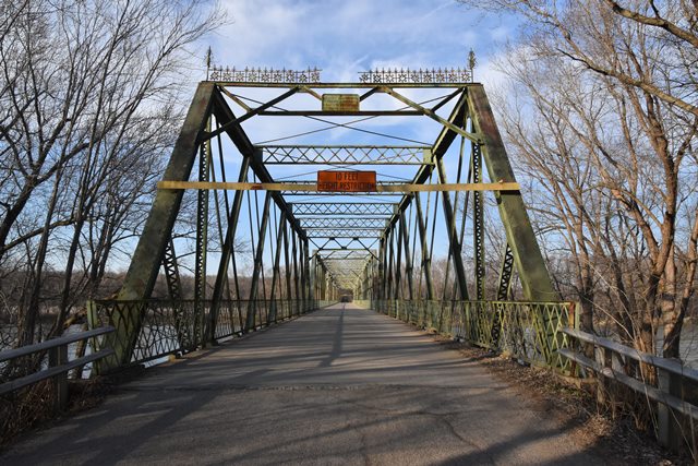
Built in 1905, this bridge is noted as an early regional example of a large rivet-connected truss bridge. Its double-intersection Warren truss design is also uncommon. On top of all this, the bridge retains good historic integrity and much of its substantial end portal ornamentation remains intact.
Information and Findings From DHPA Historic Bridge SurveyStatement of Significance At times, Warren county officers had difficulty reaching some consensus with their counterparts across the Wabash River. While Fountain county had successfully supplemented its agriculture with industrialization, Warren had relied on farming and mining. Warren county's development and its population languished as Fountain's grew apace in wealth, numbers, and urban centers. Since Fountain's growing river ports were not adjacent to Warren's smaller and quieter population centers, the two counties found it difficult to cooperate on bridging the Wabash. Fountain took the lead with timber-truss structures at Attica and Covington. Appeals for support from west of the Wabash were generally rebuffed. When Warren county put money into crossing the river, it was generally through modest support of ferries. By early in the twentieth century, however, Warren county residents found the system of Fountain-sponsored bridges and Warren-sponsored ferries too restrictive. An 1886 map of the road districts in Washington township marked the place for a new bridge needed at Shawnee. Just after the millenium, township residents voted to build the Sheffer Gravel Road to the river at Shawnee and then in 1902 formally petitioned the commissioners for a bridge. In October, the commissioners agreed to discuss the question with the Fountain county board. Not surprisingly, the overture was rebuffed. Choosing not to make the river bridge issue more divisive than necessary, the commissioners responded to the petition of weighty residents by deciding to construct two river crossings--one in the north of the county at Independence and one to the south of Williamsport. Better to seek a big bond issue than to get caught in the cross-fire of large, well-armed regional constituencies! In March 1903 the board committed itself to the construction of the Independence and the Shawnee Bridges, the first estimated to cost $35,000 and the second $45,000, and sought appropriations from the county council. In October, the board ordered Wilmer H. Gemmer to draft plans and specifications for the river bridges. Presuming that Fountain county would boycott the projects, the Warren board negotiated land transfers to it for an approach to each bridge in Fountain county by March 1904 and then met formally with the Fountain County board which duly "declined to aid this county in the construction of said bridges." The Warren commissioners approved Gemmer's plans and set the lettings for May. The Attica Bridge Company brought in the "lowest and best" bid at $89,990 for the two look-alike bridges. Attica, in turn, subcontracted with William P. Carmichael to complete the sandstone abutments and piers for the bridges. Gemmer supervised construction for the county. The Shawnee Bridge was judged complete in August 1906. The Shawnee Bridge consisted of five Lattice or Warren, full-hip, double-intersecting, 180-ft. through-truss spans for a total structure length of 810 ft. Each span is subdivided into eight panels with the only vertical being at the hip. It is crafted from two pairs of laced angles, and-- like all members--riveted at its ends to gussets. Collision struts mimic the vertical's crafting. Designed to address compression, a set of diagonals which parallels the end-posts are made of crafted I beams. The intersecting set--made to handle tension--consists of pairs of overlaid angles. Braced-A portal struts and latticed intermediate ones plus round-rod lateral bracing above and single-angle lower laterals below add stability to the trusses against moving loads. Riveted to plates above the lower chord, rectangular girder floor-beams have rolled I-beam stringers attached to their sides. Together they carry the 20-ft roadway with 19 feet and 4 inches of vertical clearance. Latticed rails line the trusses. The entrance portals carry intricate finials and decorative cresting. Over the years, the sandstone substructure has been reinforced with concrete, the stringers have been replaced, and concrete substituted for the timber deck. The Shawnee Bridge is one of a handful and the longest-extant Lattice or double-intersection Warren through-truss structures in Indiana and the product of an important midwestern fabricator. The substructure--the stone and the masons who laid it--are also noteworthy. Except for the replacement of stringers and deck, the bridge appears to retain its original members, including its latticed guardrails and struts and elaborate over-the-portal decoration. Closed in 2008. Other Information References James C. Kane, Bridge Inspection Report: Warren County (Williamsport, 1974). Indiana State Highway Commission, Inventory of Bridges on State Highway System of Indiana (Indianapolis, 1979). Farrar, Garvey & Associates, Bridge Inspection Report: Warren County (Indianapolis, 1996). Bernardin-Lochmueller & Associates, Bridge Inspection Report: Warren County (Evansville, 2000). H. Stewart Kline & Associates, Inc., Bridge Inspection Report: Fountain County (Lafayette, 1973). Reid, Quebe, et. al., Bridge Inventory & Safety Inspection: Fountain County (Indianapolis, 1979). bridge nameplate. W. H. Gemmer, "Profile of Bridge and Approaches for Wabash River Bridge," Bridge #36, Warren County Highway Department. Warren County, "Commissioners Record," 12: 64; 16: 260-267, 308, 389, 409-410, 412-413, 419, 421-422, 430; 17: 7, 17, 63, 69, 396. Bridge Considered Historic By Survey: Yes |
![]()
![]()
![]()
Coordinates (Latitude, Longitude):
Search For Additional Bridge Listings:
Bridgehunter.com: View listed bridges within 0.5 miles (0.8 kilometers) of this bridge.
Bridgehunter.com: View listed bridges within 10 miles (16 kilometers) of this bridge.
Additional Maps:
Google Streetview (If Available)
GeoHack (Additional Links and Coordinates)
Apple Maps (Via DuckDuckGo Search)
Apple Maps (Apple devices only)
Android: Open Location In Your Map or GPS App
Flickr Gallery (Find Nearby Photos)
Wikimedia Commons (Find Nearby Photos)
Directions Via Sygic For Android
Directions Via Sygic For iOS and Android Dolphin Browser
USGS National Map (United States Only)
Historical USGS Topo Maps (United States Only)
Historic Aerials (United States Only)
CalTopo Maps (United States Only)

© Copyright 2003-2026, HistoricBridges.org. All Rights Reserved. Disclaimer: HistoricBridges.org is a volunteer group of private citizens. HistoricBridges.org is NOT a government agency, does not represent or work with any governmental agencies, nor is it in any way associated with any government agency or any non-profit organization. While we strive for accuracy in our factual content, HistoricBridges.org offers no guarantee of accuracy. Information is provided "as is" without warranty of any kind, either expressed or implied. Information could include technical inaccuracies or errors of omission. Opinions and commentary are the opinions of the respective HistoricBridges.org member who made them and do not necessarily represent the views of anyone else, including any outside photographers whose images may appear on the page in which the commentary appears. HistoricBridges.org does not bear any responsibility for any consequences resulting from the use of this or any other HistoricBridges.org information. Owners and users of bridges have the responsibility of correctly following all applicable laws, rules, and regulations, regardless of any HistoricBridges.org information.
![]()