

View Information About HSR Ratings
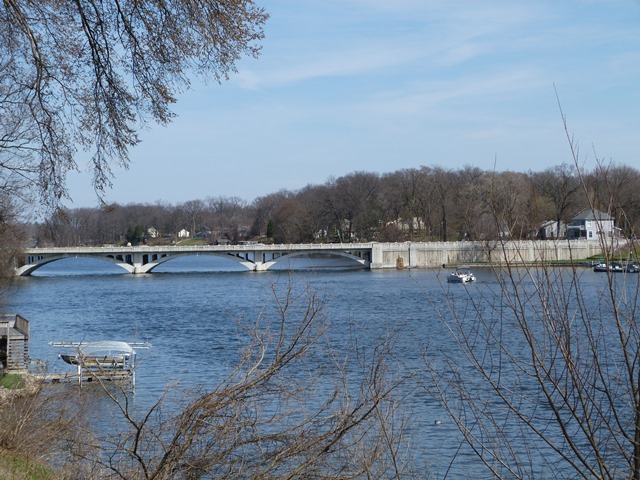
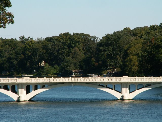
This bridge is one of the most visually striking of the concrete bridges in northern Indiana. It was the only bridge in Elkhart County and St. Joseph County to gain the attention of the HAER project. HAER documented the bridge prior to the bridge's rehabilitation which modified some aspects of the bridge, most notably the removal of lamp standards from the railings. The south end of the bridge has an extensive approach system, which consists simply of dirt retained behind a solid concrete wall that is architecturally designed to compliment the arch spans. The engineer for the bridge William S. Moore, was significant, and if you are curious about him or the details of this bridge's history, the HAER data pages include a great deal of historic about this bridge and its engineer.
Information and Findings From DHPA Historic Bridge SurveyPrevious Structure Description In August 1908, the Elkhart county commissioners noted the need for repairs to the "County Line Bridge",agreed to pay 28/72 of the same, and received bids in October. The board rejected all bids when the Elkhart Bridge & Iron Company made the only proposal, and authorized re-advertising of a letting. In November, the county received 3 bids, of which Elkhart Bridge at $3,465 brought in the lowest and successful proposal. Surveyed Structure Description The structure is about 300 feet long plus a 185-foot filled-wall approach; ribbed rings; spandrel piers; deck carried above longitudinal beams over crown of span; sidewalks extended beyond spandrel columns; deck, walks, open-arch rail panels, abutment dies with cut-triangular columns, and lampposts with cast-bronze fixtures. While the lamp fixtures were removed in the 1994 rehabilitation, much of the renovation was sensitive to original decor. References Elkhart County, "Commissioners Record," 20: 175, 194, 201. Bridge Considered Historic By Survey: Yes |
This bridge is tagged with the following special condition(s): Unorganized Photos
![]()
![]()
![]()
![]()
![]()
Coordinates (Latitude, Longitude):
Search For Additional Bridge Listings:
Bridgehunter.com: View listed bridges within 0.5 miles (0.8 kilometers) of this bridge.
Bridgehunter.com: View listed bridges within 10 miles (16 kilometers) of this bridge.
Additional Maps:
Google Streetview (If Available)
GeoHack (Additional Links and Coordinates)
Apple Maps (Via DuckDuckGo Search)
Apple Maps (Apple devices only)
Android: Open Location In Your Map or GPS App
Flickr Gallery (Find Nearby Photos)
Wikimedia Commons (Find Nearby Photos)
Directions Via Sygic For Android
Directions Via Sygic For iOS and Android Dolphin Browser
USGS National Map (United States Only)
Historical USGS Topo Maps (United States Only)
Historic Aerials (United States Only)
CalTopo Maps (United States Only)

© Copyright 2003-2025, HistoricBridges.org. All Rights Reserved. Disclaimer: HistoricBridges.org is a volunteer group of private citizens. HistoricBridges.org is NOT a government agency, does not represent or work with any governmental agencies, nor is it in any way associated with any government agency or any non-profit organization. While we strive for accuracy in our factual content, HistoricBridges.org offers no guarantee of accuracy. Information is provided "as is" without warranty of any kind, either expressed or implied. Information could include technical inaccuracies or errors of omission. Opinions and commentary are the opinions of the respective HistoricBridges.org member who made them and do not necessarily represent the views of anyone else, including any outside photographers whose images may appear on the page in which the commentary appears. HistoricBridges.org does not bear any responsibility for any consequences resulting from the use of this or any other HistoricBridges.org information. Owners and users of bridges have the responsibility of correctly following all applicable laws, rules, and regulations, regardless of any HistoricBridges.org information.
![]()