

View Information About HSR Ratings
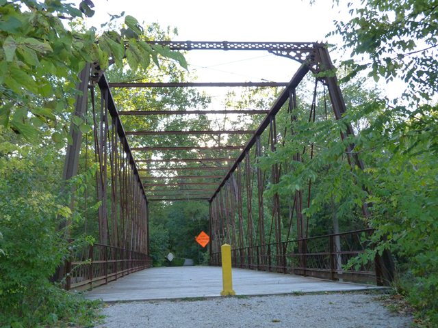
This bridge is the oldest known Whipple truss in Indiana. Additionally, this bridge is one of the oldest known surviving examples of a bridge built by the Columbia Bridge Works. The Columbia Bridge Works is a noteworthy company because its bridges display so many unusual details dissimilar to typical bridges of the period. Typical of Columbia Bridge Works bridges, this bridge is distinguished by truss members that are much more simple and plain in appearance, while the connection details for the bridge differ from standard practices followed by other period bridge companies and are quite complex in design. As an extremely old example of the company's work, and having been built during a period where all bridge companies tended to experiment more with unusual details, this bridge has some unusual details even among Columbia Bridge Works bridges. In particular, the ornate cast iron portal bracing, which only survives intact at one end of the bridge, is a noteworthy detail. This portal bracing has an unusual adjustable tension rod that runs behind the portal bracing. The hip verticals for this bridge are actually a chain of eyebars, rather than a single eyebar. The overhead bracing system also includes unusual rods that run parallel to the top chord through the middle of the sway bracing beams, except at the end panels where the rod splits into two rods and ties into the portal bracing.
This bridge is highly significant for its unusual details and its age. Another area of significance, which is quite impressive for a bridge of its age, is that there are no noteworthy alterations to the truss's original design and materials, aside from the loss of the original portal bracing at one end. This bridge remains in its original location, although the road is today used only by pedestrians as a trail, which is a perfect use for this historic bridge.
![]()
![]()
![]()
Coordinates (Latitude, Longitude):
Search For Additional Bridge Listings:
Bridgehunter.com: View listed bridges within 0.5 miles (0.8 kilometers) of this bridge.
Bridgehunter.com: View listed bridges within 10 miles (16 kilometers) of this bridge.
Additional Maps:
Google Streetview (If Available)
GeoHack (Additional Links and Coordinates)
Apple Maps (Via DuckDuckGo Search)
Apple Maps (Apple devices only)
Android: Open Location In Your Map or GPS App
Flickr Gallery (Find Nearby Photos)
Wikimedia Commons (Find Nearby Photos)
Directions Via Sygic For Android
Directions Via Sygic For iOS and Android Dolphin Browser
USGS National Map (United States Only)
Historical USGS Topo Maps (United States Only)
Historic Aerials (United States Only)
CalTopo Maps (United States Only)

© Copyright 2003-2024, HistoricBridges.org. All Rights Reserved. Disclaimer: HistoricBridges.org is a volunteer group of private citizens. HistoricBridges.org is NOT a government agency, does not represent or work with any governmental agencies, nor is it in any way associated with any government agency or any non-profit organization. While we strive for accuracy in our factual content, HistoricBridges.org offers no guarantee of accuracy. Information is provided "as is" without warranty of any kind, either expressed or implied. Information could include technical inaccuracies or errors of omission. Opinions and commentary are the opinions of the respective HistoricBridges.org member who made them and do not necessarily represent the views of anyone else, including any outside photographers whose images may appear on the page in which the commentary appears. HistoricBridges.org does not bear any responsibility for any consequences resulting from the use of this or any other HistoricBridges.org information. Owners and users of bridges have the responsibility of correctly following all applicable laws, rules, and regulations, regardless of any HistoricBridges.org information.
![]()