

View Information About HSR Ratings
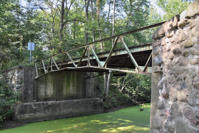
This is the only known surviving example of a patented cantilever bedstead truss bridge in Indiana. The design was patented by the Indiana Bridge Company. This bridge was originally part of a county highway but it became a park road in 1960 when Chain O Lakes Park was created. The bridge has lost its original pipe railings that were on top of the top chord. To reach this bridge you must enter the park from CR-75 South and pass the toll booth, then turn right, follow the road, taking a left at the only fork in the road, then parking where the road makes a 90 degree turn to the right (west). From this location you can walk directly on a trail south to the bridge.
Visit the CR-2325 Bridge page to learn more about this rare bridge type.
![]()
![]()
![]()
To reach this bridge you must enter the park from CR-75 South and pass the toll booth, then turn right, follow the road, taking a left at the only fork in the road, then parking where the road makes a 90 degree turn to the right (west). From this location you can walk directly on a trail south to the bridge.
Coordinates (Latitude, Longitude):
Search For Additional Bridge Listings:
Bridgehunter.com: View listed bridges within 0.5 miles (0.8 kilometers) of this bridge.
Bridgehunter.com: View listed bridges within 10 miles (16 kilometers) of this bridge.
Additional Maps:
Google Streetview (If Available)
GeoHack (Additional Links and Coordinates)
Apple Maps (Via DuckDuckGo Search)
Apple Maps (Apple devices only)
Android: Open Location In Your Map or GPS App
Flickr Gallery (Find Nearby Photos)
Wikimedia Commons (Find Nearby Photos)
Directions Via Sygic For Android
Directions Via Sygic For iOS and Android Dolphin Browser
USGS National Map (United States Only)
Historical USGS Topo Maps (United States Only)
Historic Aerials (United States Only)
CalTopo Maps (United States Only)

© Copyright 2003-2025, HistoricBridges.org. All Rights Reserved. Disclaimer: HistoricBridges.org is a volunteer group of private citizens. HistoricBridges.org is NOT a government agency, does not represent or work with any governmental agencies, nor is it in any way associated with any government agency or any non-profit organization. While we strive for accuracy in our factual content, HistoricBridges.org offers no guarantee of accuracy. Information is provided "as is" without warranty of any kind, either expressed or implied. Information could include technical inaccuracies or errors of omission. Opinions and commentary are the opinions of the respective HistoricBridges.org member who made them and do not necessarily represent the views of anyone else, including any outside photographers whose images may appear on the page in which the commentary appears. HistoricBridges.org does not bear any responsibility for any consequences resulting from the use of this or any other HistoricBridges.org information. Owners and users of bridges have the responsibility of correctly following all applicable laws, rules, and regulations, regardless of any HistoricBridges.org information.
![]()