

View Information About HSR Ratings
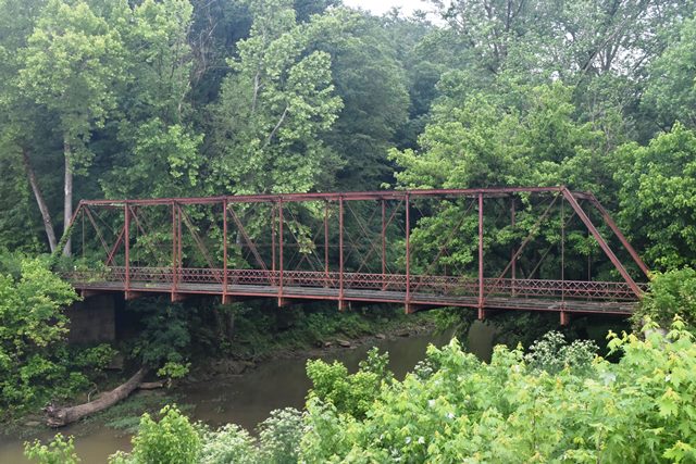
This bridge has the distinctive details of a bridge built by the Indianapolis Bridge Company. It includes cast iron decorative portal bracing knees. In 2020, this bridge was relocated to Rice Island in Corydon.
Estimated new location: https://goo.gl/maps/553QQHwFtpjNpqx6A
38.209827, -86.118508
Information and Findings From DHPA Historic Bridge SurveyBridge History and Significance The Indianapolis Bridge Company of Indianapolis, Indiana, fabricated this single-span, pin-connected Pratt through truss which is seated upon cut stone abutments and wingwalls. Intermediate verticals of crafted I beams subdivide the 123' truss into most of its ten panels. Eyebars provide the diagonals: adjustable pairs stretch toward center span from the top panel point to the bottom of all except the endpost panels; a cylindrical eyebar with a turnbuckle counters the pairs in all but the two outer panels at each end. An adjustable cylindrical eyebar runs horizontally through the intermediate verticals about midway between the chords. U-bolted to the lower pins, girder floor-beams carry the timber deck with its 13'8" roadway and 15' of vertical clearance. One of four extant Pratts constructed by a prolific Indiana firm, this bridge retains its integrity. Its decoratively latticed portals, cast iron portal bracing and other fixtures, and unusual guardrails are all intact. Bypassed for vehicles in 2001; structure to be preserved in place. References M.W., Inc., Harrison County Bridge Inspection/ Reinspection Report (Indianapolis, 1974, 1979). United Consulting Engineers, Bridge Inventory Report: Harrison County (Indianapolis, 2002). Bridge Considered Historic By Survey: Yes |
![]()
![]()
![]()
This historic bridge has been relocated and is no longer at this location. See the main bridge page for a link to the new bridge location. This map is shown for reference purposes only.
Coordinates (Latitude, Longitude):
Search For Additional Bridge Listings:
Bridgehunter.com: View listed bridges within 0.5 miles (0.8 kilometers) of this bridge.
Bridgehunter.com: View listed bridges within 10 miles (16 kilometers) of this bridge.
Additional Maps:
Google Streetview (If Available)
GeoHack (Additional Links and Coordinates)
Apple Maps (Via DuckDuckGo Search)
Apple Maps (Apple devices only)
Android: Open Location In Your Map or GPS App
Flickr Gallery (Find Nearby Photos)
Wikimedia Commons (Find Nearby Photos)
Directions Via Sygic For Android
Directions Via Sygic For iOS and Android Dolphin Browser
USGS National Map (United States Only)
Historical USGS Topo Maps (United States Only)
Historic Aerials (United States Only)
CalTopo Maps (United States Only)

© Copyright 2003-2024, HistoricBridges.org. All Rights Reserved. Disclaimer: HistoricBridges.org is a volunteer group of private citizens. HistoricBridges.org is NOT a government agency, does not represent or work with any governmental agencies, nor is it in any way associated with any government agency or any non-profit organization. While we strive for accuracy in our factual content, HistoricBridges.org offers no guarantee of accuracy. Information is provided "as is" without warranty of any kind, either expressed or implied. Information could include technical inaccuracies or errors of omission. Opinions and commentary are the opinions of the respective HistoricBridges.org member who made them and do not necessarily represent the views of anyone else, including any outside photographers whose images may appear on the page in which the commentary appears. HistoricBridges.org does not bear any responsibility for any consequences resulting from the use of this or any other HistoricBridges.org information. Owners and users of bridges have the responsibility of correctly following all applicable laws, rules, and regulations, regardless of any HistoricBridges.org information.
![]()