

View Information About HSR Ratings
This bridge was built to cross a new realignment of the Patoka River that had been completed. The effort to create this new straight river channel was not entirely successful, and water continued to flow through the old river at times. The old river bridge, also historic, remains in place a short distance south of this bridge.
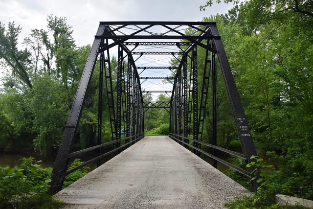
Information and Findings From DHPA Historic Bridge SurveyStatement of Significance Resting atop concrete abutments and wingwalls, this through Camelback follows a popular pattern for a short version of this truss. Laced channels divide the 144' span into eight panels (three central; two for each side section; one under each endpost). Central panels have crossed diagonals; side panels angle diagonals only toward span center from the top chord. All diagonals and the lower chord on this truss are fabricated from angles and stay plates; there are no eyebars or turnbuckles. I floor-beams are bolted to gussets and the verticals above the lower chord. The concrete deck provides a 15'7" roadway and 18 feet of vertical clearance. This truss retains its original members and is one of five extant bolted Camelbacks. References Ohio Valley Engineers, Bridge Inspection Survey and Report: Pike County (Evansville, 1974). United Consulting Engineers, Inc., Bridge Reinspection Report for Pike County (Indianapolis, 1980). Bridge Considered Historic By Survey: Yes |
![]()
![]()
![]()
Coordinates (Latitude, Longitude):
Search For Additional Bridge Listings:
Bridgehunter.com: View listed bridges within 0.5 miles (0.8 kilometers) of this bridge.
Bridgehunter.com: View listed bridges within 10 miles (16 kilometers) of this bridge.
Additional Maps:
Google Streetview (If Available)
GeoHack (Additional Links and Coordinates)
Apple Maps (Via DuckDuckGo Search)
Apple Maps (Apple devices only)
Android: Open Location In Your Map or GPS App
Flickr Gallery (Find Nearby Photos)
Wikimedia Commons (Find Nearby Photos)
Directions Via Sygic For Android
Directions Via Sygic For iOS and Android Dolphin Browser
USGS National Map (United States Only)
Historical USGS Topo Maps (United States Only)
Historic Aerials (United States Only)
CalTopo Maps (United States Only)

© Copyright 2003-2024, HistoricBridges.org. All Rights Reserved. Disclaimer: HistoricBridges.org is a volunteer group of private citizens. HistoricBridges.org is NOT a government agency, does not represent or work with any governmental agencies, nor is it in any way associated with any government agency or any non-profit organization. While we strive for accuracy in our factual content, HistoricBridges.org offers no guarantee of accuracy. Information is provided "as is" without warranty of any kind, either expressed or implied. Information could include technical inaccuracies or errors of omission. Opinions and commentary are the opinions of the respective HistoricBridges.org member who made them and do not necessarily represent the views of anyone else, including any outside photographers whose images may appear on the page in which the commentary appears. HistoricBridges.org does not bear any responsibility for any consequences resulting from the use of this or any other HistoricBridges.org information. Owners and users of bridges have the responsibility of correctly following all applicable laws, rules, and regulations, regardless of any HistoricBridges.org information.
![]()