

View Information About HSR Ratings
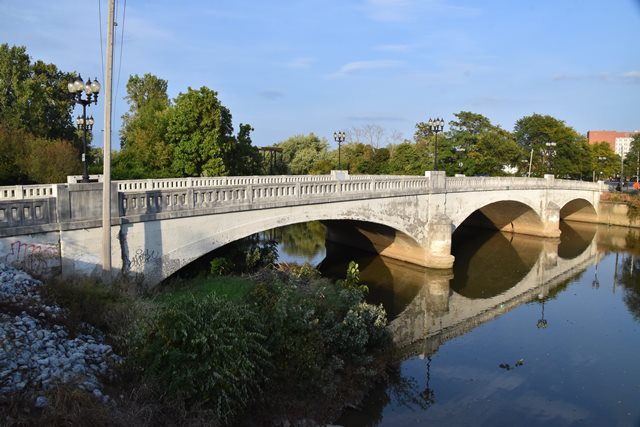
This is one of several bridges in the city designed by A. W. Grosvenor who was known for using Melan reinforcing as he did in this bridge. The bridge originally had a brick railing, which has been replaced with a concrete railing. Despite this alteration, the bridge retains its Melan arch design and is an important historic bridge.

Above: Photo showing original railing in 1995. Photo Credit: Dr. James Cooper.

Above: 1995 photo showing deterioration which exposed Melan reinforcing. Photo Credit: Dr. James Cooper.

Above: Historical photo showing previous bridge at this location.
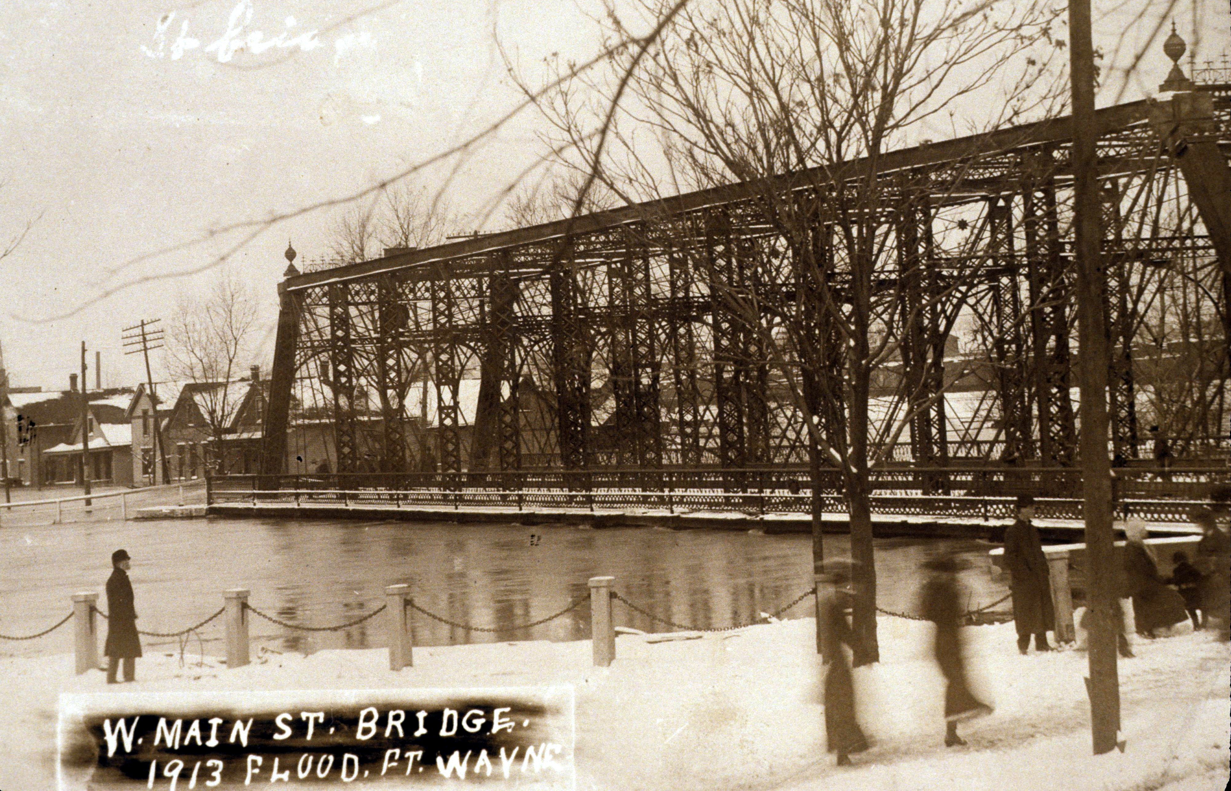
Above: Historical photo showing previous bridge at this location.
Information and Findings From DHPA Historic Bridge SurveyStatement of Significance Previous Timber Structure (1864 - 1878) Gould reported that Hall & Kimball built a covered timber truss structure over St. Mary's River on W. Main Street in Fort Wayne in 1864. The structure was replaced in 1878 with an iron superstructure. Prior Metal Structure(s) (1878 - 1921) The Allen County commissioners refused the Ft. Wayne Street Railway permission to lay double tracks on the W. Main Street Bridge in October 1893. In early November, the board received bids to move the Old or W. Main Street Bridge of one 165-foot span with an 18-foot roadway and a pair of 5-foot sidewalks to Van Buren Street over the St. Mary's River. The bridge was to be cleaned and painted with graphite paint. The county accepted the next lowest of the bids -- that of the Jackson Bridge Company of Jackson, Michigan, for $1,440. The board accepted the relocated bridge in February 1894. In January 1919, the county commissioners agreed to build a new West Main Street Bridge in the spring of 1920 to address the heavy vehicle traffic there. In July residents of the west end of Fort Wayne prepared a petition seeking the replacement of the existing iron West Main street bridge with a concrete structure. While replacement was at the top of the county's list, residents wanted immediate action to replace what they regarded as a too-narrow and too-costly structure. Surveyed Structure (1921 - ) In the second decade of the twentieth century, A. W. Grosvenor of Fort Wayne designed about a half-dozen reinforced-concrete arched structures built in the region. In February 1920, Allen county hired Asa Grosvenor to draft plans for the Main Steet Bridge at the rate of $100 per days, not to exceed a total cost of $3,000. Grosvenor's plans were submitted to and approved by the Indiana State Highway Commission. The rings are offset, segmental, probably reinforced with the Melan system, and raised vertically upon the piers. Solid spandrel walls retain the earth fill upon which rests the asphalt roadway and 6-foot and 6-inch concrete sidewalks between stone and brick rails. The original rail panels were made of dark brick and its posts and copings of light stone. The piers are decorated and their towers inlaid with brick and stone. Herman W. Tapp of Fort Wayne beat out I. E. Smith of Richmond for the construction contract of $151,000 in May. Tapp was paid in installments, the final one coming in October. Like a number of Grosvenor's structures, this one was unusually well decorated using a variety of materials. The structure is also noteworthy for its skew. The 1997 reconstruction of the deck replaced the parapet rails with heavy coped and open-arch panelled ones. References (1864 - 1878) George Gould, Indiana Covered Bridges Thru the Years, (Indianapolis, 1977), 20, 28-29, 48. (1878 - 1921) Allen County, "Commissioners Record," X: 39, 49, 53-54. "New West Main St. Bridge," "To file Bridge Petition," Fort Wayne News-Sentinel, 15 January 1919: 1; 14 July 1919: 16. (1921 - ) Butler, Fairman & Seufert, Inc., Bridge Inspection/Reinspection Report: Allen County (Indianapolis, 1973, 1977, 1981). SIECO, Inc., Bridge Reinspection Report: Allen County (Columbus, 1993, 1995). Farrar, Garvey and Associates, Inc., Bridge Inspection Report: Allen County (Indianapolis, 1997, 1999, 2004). bridge nameplate. Allen County, "Commissioners Record," 14: 25, 70, 85-86, 136-137, 178-179, 199-200, 201-202, 259-260, 280, 349-350, 392, 402, 451, 484. Allen County, "Old Bridges" (Surveyor's Office), 13E: 11. "Fort Wayne - Bridges - Allen Co.", Construction News, Engineering News-Record, 22 April 1920: 229; 13 May 1920: 347. Plaques Carved in concrete (2 plaques): Other Information Not Currently Available. Bridge Considered Historic By Survey: Yes |
This bridge is tagged with the following special condition(s): Melan
![]()
![]()
![]()
Coordinates (Latitude, Longitude):
Search For Additional Bridge Listings:
Bridgehunter.com: View listed bridges within 0.5 miles (0.8 kilometers) of this bridge.
Bridgehunter.com: View listed bridges within 10 miles (16 kilometers) of this bridge.
Additional Maps:
Google Streetview (If Available)
GeoHack (Additional Links and Coordinates)
Apple Maps (Via DuckDuckGo Search)
Apple Maps (Apple devices only)
Android: Open Location In Your Map or GPS App
Flickr Gallery (Find Nearby Photos)
Wikimedia Commons (Find Nearby Photos)
Directions Via Sygic For Android
Directions Via Sygic For iOS and Android Dolphin Browser
USGS National Map (United States Only)
Historical USGS Topo Maps (United States Only)
Historic Aerials (United States Only)
CalTopo Maps (United States Only)

© Copyright 2003-2024, HistoricBridges.org. All Rights Reserved. Disclaimer: HistoricBridges.org is a volunteer group of private citizens. HistoricBridges.org is NOT a government agency, does not represent or work with any governmental agencies, nor is it in any way associated with any government agency or any non-profit organization. While we strive for accuracy in our factual content, HistoricBridges.org offers no guarantee of accuracy. Information is provided "as is" without warranty of any kind, either expressed or implied. Information could include technical inaccuracies or errors of omission. Opinions and commentary are the opinions of the respective HistoricBridges.org member who made them and do not necessarily represent the views of anyone else, including any outside photographers whose images may appear on the page in which the commentary appears. HistoricBridges.org does not bear any responsibility for any consequences resulting from the use of this or any other HistoricBridges.org information. Owners and users of bridges have the responsibility of correctly following all applicable laws, rules, and regulations, regardless of any HistoricBridges.org information.
![]()