

View Information About HSR Ratings
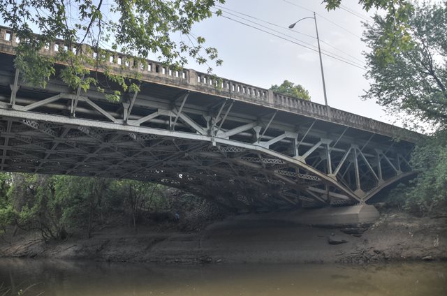
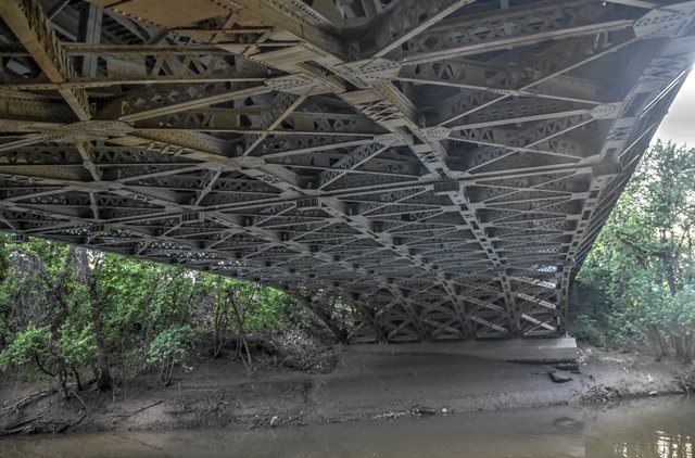
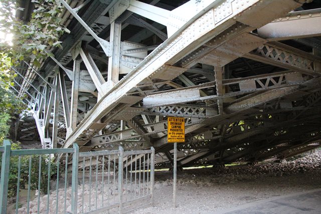
This is a very unusual multi-ribbed small-scale cantilever deck truss. Most truss bridges have two truss lines, but this bridge has six closely spaced truss lines. The bridge has anchor arms and cantilever arms taking on a Pratt truss configuration, while the small approximately 60 foot suspended span in the center of the bridge has a Warren truss configuration. As of 2020, planning is taking place for some minor repairs to the bridge, particularly around the anchor bearings.

Above: Historical postcard of previous bridge at this location.
Information and Findings From DHPA Historic Bridge SurveyStatement of Significance The current Franklin Street Bridge is a product of a legal struggle in the Superior Court of Vanderburgh County in 1930. Over seven months in the spring and summer of 1930 at at a cost of $6,000, County Surveyor Rudolph Meisinger had prepared with the assistance of "a Purdue engineer" plans for a "steel cantilever type of of bridge" (cantilevered arms and suspended Warren span) with a concrete roadway and railings. The county advertized the Meisinger plans for letting but also, without advertizing, permitted the submission of plans for a Luten-design concrete arch. At the letting the National Concrete Company proposed to construct the Luten-design arch for $166,500, and the International Steel & Iron Company of Evansville proposed to build to the Meisinger plans for $167,000. The commissioners accepted the National Concrete proposal, and Charles R. Tiebourt, chief engineer of IS&I appealed the award to the county Superior Court. Judge Edwin C. Henning subsequently voided the county's contract with National Concrete which had already torn down half of the old bridge before the injunction stopped its work. The commissioners ordered the readvertizing of the Meisinger plans (which had been somewhat revised by E. L. Erickson, consulting engineer), and the Globe Construction Company of Evansville brought in the lowest and successful bid at $129,890 in early October 1931. Although IS&I had unsuccessfully bid on the Meisinger plans at $163,765, the firm's attorney examined Globe's bid and bond and "pronounced the papers faultless." The new bridge was open to traffic in May 1932. The line of six riveted, arched, and cantilevered trusses span 64-feet from the concrete abutments to the concrete-capped, cut-stone piers where a hinged or pinned 56-foot arm extends towards the suspended span. Pinned or hinged to the cantilevered arms from each end, the riveted 62-foot suspended span carries parallel chords. The top chords, made from a pair of crafted I-beams riveted together with battens and carrying an extra cover plate, are horizontal. The arched lower chords are also made from a pair of crafted I-beams riveted together with battens but without the extra cover plate used on the top chord. Crafted I-beams supply the verticals as well. The diagonals of laced channels reinforced with an added plate are the heaviest web members. The structure carries a concrete deck. Brackets added outside the trusses suport a 6-foot sidewalk astride the roadway. The deck and the original open-panel concrete railings were replaced in 1995. Cantilevered trusses with suspended spans have more often appeared on the borders of Indiana, generally over the Ohio River, than over the state's internal waterways. This is the only known county bridge of its type and the earliest example of its kind on a Hoosier highway. To construct a 174-foot center span across Pigeon Creek with deck trusses required this kind of special design effort. Cantilevered deck trusses with suspended spans were built on the American landscape considerably more at and after the Second World War. Previous Structure (1894-1930) The commissioners received a formal offer from the Evansville Street Railway Company to assist with the replacement of the Franklin Street covered bridge. The board rejected the offer as inadequate in October 1892. The following June, the board paid C. C. Genung $215 for the plans and specifications for both a new Franklin Street substructure and superstructure. Fourteen metal fabricators bid in the July letting, with the Massachusetts Bridge Company bringing in the lowest and winning proposal at $29,699. Commissioner Simon Hartig visited Pittsburgh to view the material to be used for the bridge superstructure in August. Eigenmann & Hollenbach secured the contract for the substructure and received payments for their work into January 1894. The final claim of Eigenmann & Hollenback became so contentious that it ended up in court and was not settled until 1897. Massachusetts Bridge received its final payment in April 1894. Photographs suggest that Massachusetts Bridge erected a Warren through-truss structure capable of carrying a street railway. References Previous Structure Vanderburgh County, "Commissioners Record," G-1: 390; H-1: 63, 130-131, 174, 230, 279, 325, 329, 391, 442, 452; I-1: 176; J-1: 523, 583. "Evansville Street Railroad Company," Book of Evansville. Surveyed Structure Vanderburgh County Surveyor's Office, Bridge Inspection Survey and Report: Vanderburgh County (Evansville, 1973). Sieco, Inc., Bridge Inspection Report: Vanderburgh County (Columbus, 1979). bridge plate. bridge plans, Vanderburgh County Engineer. "Brief News," Engineering News-Record, 4 December 1930: 901. "Evansville - Bridges," clipping file, Central Library (Evansville): "Auditor Advises Readvertising of Meisinger Plans," 8 April 1931; "New Span Action by County Board Seen as Probable," 9 April 1931; "Here's Franklin Street Span That Koenemann Advocates," 12 April 1931, drawing and text; "Globe Firm Wins Franklin Street Bridge Contract," 9 October 1931, Evansville Courier; "New Bridge is Asset to Traffic," 1 June 1932, Evansville Courier. Bridge Considered Historic By Survey: Yes |
This bridge is tagged with the following special condition(s): Unorganized Photos
![]()
![]()
![]()
![]()
![]()
Coordinates (Latitude, Longitude):
Search For Additional Bridge Listings:
Bridgehunter.com: View listed bridges within 0.5 miles (0.8 kilometers) of this bridge.
Bridgehunter.com: View listed bridges within 10 miles (16 kilometers) of this bridge.
Additional Maps:
Google Streetview (If Available)
GeoHack (Additional Links and Coordinates)
Apple Maps (Via DuckDuckGo Search)
Apple Maps (Apple devices only)
Android: Open Location In Your Map or GPS App
Flickr Gallery (Find Nearby Photos)
Wikimedia Commons (Find Nearby Photos)
Directions Via Sygic For Android
Directions Via Sygic For iOS and Android Dolphin Browser
USGS National Map (United States Only)
Historical USGS Topo Maps (United States Only)
Historic Aerials (United States Only)
CalTopo Maps (United States Only)

© Copyright 2003-2024, HistoricBridges.org. All Rights Reserved. Disclaimer: HistoricBridges.org is a volunteer group of private citizens. HistoricBridges.org is NOT a government agency, does not represent or work with any governmental agencies, nor is it in any way associated with any government agency or any non-profit organization. While we strive for accuracy in our factual content, HistoricBridges.org offers no guarantee of accuracy. Information is provided "as is" without warranty of any kind, either expressed or implied. Information could include technical inaccuracies or errors of omission. Opinions and commentary are the opinions of the respective HistoricBridges.org member who made them and do not necessarily represent the views of anyone else, including any outside photographers whose images may appear on the page in which the commentary appears. HistoricBridges.org does not bear any responsibility for any consequences resulting from the use of this or any other HistoricBridges.org information. Owners and users of bridges have the responsibility of correctly following all applicable laws, rules, and regulations, regardless of any HistoricBridges.org information.
![]()