

View Information About HSR Ratings
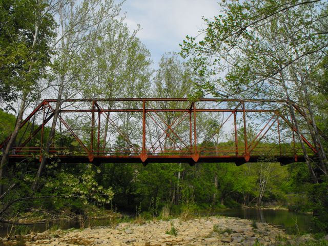
This bridge was constructed c. 1915 to carry a railroad line, which apparently was not a very successful line, and the bridge was apparently converted to vehicular use in 1920. The old railroad line is still discernable leading away from the bridge, however the highway which today utilizes the bridge does not run along this former railroad line's location. Since that conversion, the bridge has functioned in place in essentially unaltered condition. Today, the bridge is distinguished as eligible for the National Register of Historic Places as an excellent, unaltered, and relatively early surviving example of its type, a riveted Pratt through truss.
The traditionally composed seven panel truss with 18 feet vertical clearance above roadway is configured as follows (dimensions given are approximate sizes accurate within .5 inches). End post and top chord: back-to-back channels with cover plate and v-lacing, beam size 14 inches by 9.5 inches. Bottom chord: two angles with battens, beam width 8 inches. Railing: two channels, each 3 inches high. Hip vertical members: two angles with battens, size 8 inches by 3 inches. Other vertical members: back-to-back channels with v-lacing on each side, beam size 6 inches by 12 inches. Diagonal members: two angles with battens, size 5 inches by 8 inches (outer members) and 3 inches by eight 8 (inner members). Sway struts: two paired angles with v-lacing. Knee bracing: paired angles. Portal bracing: A-frame design composed of paired angles.
The bridge was recently closed to traffic, largely because the bottom chord connection to the endpost broke apart due to what appears to be a combination of section loss and shifting of the abutments. Prior to closure, the condition of the bridge was actually fairly good, and was as follows:
2007 National Bridge Inventory Bridge Inspection Results:
Deck condition rating: Satisfactory (6 out of 9)
Superstructure
condition rating: Fair (5 out of 9)
Substructure condition rating: Fair (5
out of 9)
Appraisal: Functionally obsolete
Sufficiency rating: 44.3
Posted Weight Limit Prior To Closure: 10 Tons
These are excellent ratings for a c. 1915 bridge that has never received a comprehensive rehabilitation and strongly suggest a bridge that is in a condition for which rehabilitation is feasible and economic. The bridge was not even listed structurally deficient at this time, only functionally obsolete. The fact that the bridge instantly went from these relatively good ratings to total structure closure is indicative of a bridge for which there is an isolated severe problem, with the overall bridge remaining in fair condition. This interpretation appeared to be confirmed based upon the results of the HistoricBridges.org field inspection of the bridge. This field inspection confirmed that the gusset plates that connects the northeast corner end post and bottom chord to each other at the bearing point had broken apart. The other end post / bottom chord connections were deteriorated, but not so much as this corner. Other areas of deterioration included 100% section loss on portions of some of the battens on the bottom chord (although the angles they connect to are in good condition) and there was also varying section loss on the vertical members where the railings connect to them. However, the remainder of the bridge, which is the majority of the bridge, remains in relatively good shape. Overall, this appears to be a bridge for which rehabilitation is feasible and economic, and very well may taxpayer less total dollars than the cost of replacement.
Despite successfully preserving historic bridges elsewhere in the county, Dearborn County has proposed the demolition and replacement of this historic bridge, with a 2013 date slated. The project would construct a new bridge on a different alignment, and then the historic bridge would be demolished afterward. A number of local residents are strongly opposed to this and they would prefer to see the historic bridge rehabilited and placed onto new abutments on the new alignment. HistoricBridges.org agrees that this is a good solution for the project. New abutments on a different alignment would correct the problems with the current substructure, which is damaging the truss, and would also improve the alignment of the crossing, making accidents at the crossing less likely. Placing the historic bridge on these new abutments would retain the historic structure, quite possibly reduce the total cost to taxpayers, could potentially be completed sooner than the 2013 date, and would meet the needs of the local community who uses the bridge.
Based on a basic visual inspection of the bridge and comments from area residents with whom HistoricBridges.org met, the best option appears to be to remove the truss bridge from the abutments as soon as possible, build new abutments on new and improved alignment, rehabilitate truss and place on abutments. Traffic control devices such as stop signs could be installed to control the flow of traffic. Visual examination provided the following suggested preservation work on the truss itself. Replicate/replace base of endposts and ends of bottom chord and associated connections, particularly at the northeast corner. Remove railings and repair section loss (perhaps weld plates to this area) where the railings were mounted. Hammer minor pack rust out of connection gusset plates. Replace bottom chord battens. A focus should be placed on replacing severely deteriorated elements in-kind to maintain historic integrity. Finally, although the part of the structure with the historic significance is the truss superstructure, it may be possible to place the stones from the old abutment around a new, modern concrete abutment to maintain the stone appearance of the substructure.
Information and Findings From DHPA Historic Bridge SurveyStatement of Significance Riveted Pratt through structures are not plentiful in Indiana. The design of this one is fairly standard. The undecorated bridge retains its original members. Architectural Description Seated upon cut stone abutments and wingwalls, this single-span, riveted Pratt through structure extends 135'7" in seven panels. A pair of laced channels provides each set of intermediate verticals, and a pair of angles riveted together with battens serves each diagonals and counter set. Diagonals are countered in the three most central panels. The I floor beams are riveted to gussets below the lower chord. The bridge carries an asphalt-over-concrete deck with a 13' roadway and 18' of vertical clearance. Other Information This bridge is eligible under Criterion C as it represents an early or distinctive phase in bridge construction, design, or engineering, and it retains the historic integrity necessary to convey its engineering significance. Rationale: This bridge was built during the initial period of development or application of standards for its type in Indiana. As such, it represents an important phase in construction. This bridge does not appear to possess significance under the National Register evaluation system for Criterion A. No evidence was found during data collection activities to indicate that this bridge possesses a significant association with important historical events or trends. As such, it is recommended not eligible under Criterion A. Dearborn County Bridge #55 Bridge Considered Historic By Survey: Yes |
![]()

![]()

![]()
![]()
![]()
This historic bridge has been demolished. This map is shown for reference purposes only.
Coordinates (Latitude, Longitude):
Search For Additional Bridge Listings:
Bridgehunter.com: View listed bridges within 0.5 miles (0.8 kilometers) of this bridge.
Bridgehunter.com: View listed bridges within 10 miles (16 kilometers) of this bridge.
Additional Maps:
Google Streetview (If Available)
GeoHack (Additional Links and Coordinates)
Apple Maps (Via DuckDuckGo Search)
Apple Maps (Apple devices only)
Android: Open Location In Your Map or GPS App
Flickr Gallery (Find Nearby Photos)
Wikimedia Commons (Find Nearby Photos)
Directions Via Sygic For Android
Directions Via Sygic For iOS and Android Dolphin Browser
USGS National Map (United States Only)
Historical USGS Topo Maps (United States Only)
Historic Aerials (United States Only)
CalTopo Maps (United States Only)

© Copyright 2003-2024, HistoricBridges.org. All Rights Reserved. Disclaimer: HistoricBridges.org is a volunteer group of private citizens. HistoricBridges.org is NOT a government agency, does not represent or work with any governmental agencies, nor is it in any way associated with any government agency or any non-profit organization. While we strive for accuracy in our factual content, HistoricBridges.org offers no guarantee of accuracy. Information is provided "as is" without warranty of any kind, either expressed or implied. Information could include technical inaccuracies or errors of omission. Opinions and commentary are the opinions of the respective HistoricBridges.org member who made them and do not necessarily represent the views of anyone else, including any outside photographers whose images may appear on the page in which the commentary appears. HistoricBridges.org does not bear any responsibility for any consequences resulting from the use of this or any other HistoricBridges.org information. Owners and users of bridges have the responsibility of correctly following all applicable laws, rules, and regulations, regardless of any HistoricBridges.org information.
![]()