We Recommend:
Bach Steel - Experts at historic truss bridge restoration.
Hart Road Bridge
Martin County Bridge 59

Primary Photographer(s): Nathan Holth
Bridge Documented: May 22, 2021
Rural: Martin County, Indiana: United States
Metal 3 Panel Pin-Connected Pratt Half-Hip Pony Truss, Fixed and Approach Spans: Metal 4 Panel Pin-Connected Pratt Half-Hip Pony Truss, Fixed
1900 By Builder/Contractor: Champion Bridge Company of Wilmington, Ohio
1993
61.7 Feet (18.8 Meters)
111.0 Feet (33.8 Meters)
11.8 Feet (3.6 Meters)
1 Main Span(s) and 1 Approach Span(s)
5100030

View Information About HSR Ratings
Bridge Documentation
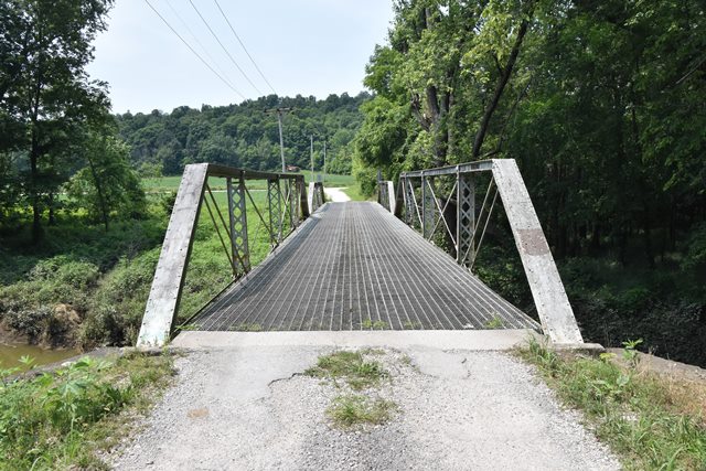
This bridge with its two unequal spans is a rare example of a multi-span pin-connected pony truss bridge. Most surviving pony truss bridges with pin connections are single span bridges. This bridge is also a notable example of the Champion Bridge Company, which was more prolific in other states like Ohio and Tennessee.
The National Bridge Inventory showed a 1913 construction date, however the DHPA notes listed a ca. 1900 date. Given the lightweight trusses, and built-up floorbeams, and the stone substructure, the 1900 date seems more likely.
View Archived National Bridge Inventory Report - Has Additional Details and Evaluation
Information and Findings From DHPA Historic Bridge SurveyBridge History and Significance Built by the Champion Bridge Company of Wilmington, Ohio, the two-span, pin-connected Pratt pony truss rests upon its original cut stone abutments, wingwalls, and pier. The structure extends 113' in three and four panels each. Its verticals are fabricated of laced pairs of angles and its diagonals of a pair of die-forged and rectangular eyebars countered by an adjustable bar in the center panels of the longest span and crossed in the center panel of the shortest span. I floor-beams, which are double U-bolted to the lower pins, carry the timber deck with its 12' roadway. One of three extant Pratt ponies fabricated by the prolific Ohio firm, this is also one of the three surviving two-span structures of this truss type in Indiana. The unadorned bridge retains its original substructure and metal members, although some have undergone repair. The truss design is quite standard. References Bridge nameplate. American Consulting Engineers, Inc., Bridge Inspection/Reinspection Report: Martin County (Indianapolis, 1974, 1979). Bridge Considered Historic By Survey: Yes |
![]()
Photo Galleries and Videos: Hart Road Bridge
Bridge Photo-Documentation
Original / Full Size PhotosA collection of overview and detail photos. This gallery offers photos in the highest available resolution and file size in a touch-friendly popup viewer.
Alternatively, Browse Without Using Viewer
![]()
Bridge Photo-Documentation
Mobile Optimized PhotosA collection of overview and detail photos. This gallery features data-friendly, fast-loading photos in a touch-friendly popup viewer.
Alternatively, Browse Without Using Viewer
![]()
Maps and Links: Hart Road Bridge
Coordinates (Latitude, Longitude):
Search For Additional Bridge Listings:
Bridgehunter.com: View listed bridges within 0.5 miles (0.8 kilometers) of this bridge.
Bridgehunter.com: View listed bridges within 10 miles (16 kilometers) of this bridge.
Additional Maps:
Google Streetview (If Available)
GeoHack (Additional Links and Coordinates)
Apple Maps (Via DuckDuckGo Search)
Apple Maps (Apple devices only)
Android: Open Location In Your Map or GPS App
Flickr Gallery (Find Nearby Photos)
Wikimedia Commons (Find Nearby Photos)
Directions Via Sygic For Android
Directions Via Sygic For iOS and Android Dolphin Browser
USGS National Map (United States Only)
Historical USGS Topo Maps (United States Only)
Historic Aerials (United States Only)
CalTopo Maps (United States Only)

