

View Information About HSR Ratings
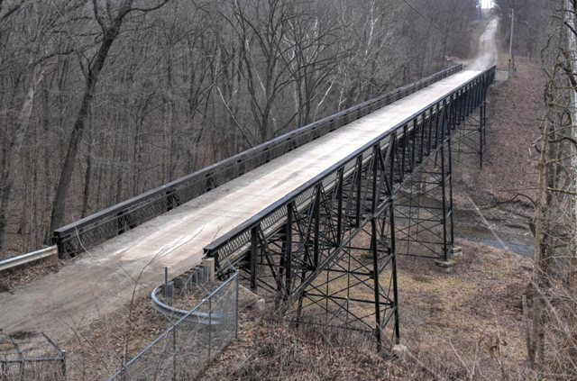
This very unusual high level highway half-deck or railing height truss bridge has been nicely preserved.
Information and Findings From DHPA Historic Bridge SurveyStatement of Significance The main road used from the mid-nineteenth century forward from Independence to Green Hill crossed Little Pine Creek where it had dug deep into the countryside. The steep banks led Warren township petitioners to seek a trestle across the ravine rather than a conventional bridge from creek bank to bank. In March 1897, the county commissioners asked surveyor-engineer, Wilmer H. Gemmer, to survey the site along with six others. In April he reported his estimates to the board, and in May he offered plans for all except the Little Pine Creek crossing which was the most complicated and the most expensive to build. Plans to advertise a letting for even the six smaller bridges induced a formal protest from E. C. Livingood, one of the three commissioners. Gemmer and the commissioners let the political dust settle before he came in with plans for a Pratt deck-truss structure raised on metal towers for the site. Not until January 1902 did the commissioners authorize a letting, and in February the Lafayette Engineering Company secured a $7,000 contract to build the "viaduct." The road over High Bridge was soon improved as the Green Hill and Independence Gravel Road. In January 1925, the district road superintendent complained to the commissioners of the "dangerous condition" of the bridge, and in March the board ordered J. R. Gregory to survey the structure. Gregory apparently decided that Gemmer's bridge--even though not that old--needed to be replaced. At the boards request, he prepared alternate plans for a replacement--one for a concrete arch; a second for Pratt through-truss spans on towers. The September bidding on the two options for High Bridge brought in bids well above the engineer's estimates, and so the board rejected them. In March 1926, the board noted that a new High Bridge would require borrowing, and did not request appropriation from the county council through a bond issue until a year later, by which time Otus K. Albright had become county surveyor and engineer. Unlike his predecessors, Albright came from Pine Village--not the Williamsport area--and had a degree in civil engineering from Purdue University. When the board asked him for plans in June 1927, Albright kept Gregory's proposal for an arch but scrapped the design for through-trusses and substituted instead an all-riveted Pratt half-deck structure. In the August bidding, E. G. Jarrell of Muncie came in with the lowest and therefore best bid at $35,368 for the steel design. Probably on Albright's advice, the board also hired the H. C. Nutting Company of Cincinnati, Ohio, to inspect the shop work and field erection of the bridge. High Bridge was essentially complete by February 1928. High Bridge is seated on concrete abutments and wingwalls and three pier towers between spans. The pier towers rest on concrete bases. I beams provide the pier posts which are stiffened with four horizontal struts made from heavy angles and lateral braces, also of angles, all riveted to gussets. The superstructure consists of four Pratt half-deck spans together extending 430 ft. The eastern end span clears 62 ft. the adjoining river span over 123 ft, and the last two spans 92 ft. 6 in. in 15-ft. 5-in. panels between supports. The panel over each tower is 20 ft. wide. The vertical end-posts and top-chord members consist of a pair of channels, cover plate, and battens; the channels used over the second span from the east are heavier than the others. Two pairs of angles and battens make up the lower-chord members. The posts in the trusses, like the verticals in the towers, rely on I beams. Most varied of the web members, the diagonals are heaviest in the outer panels (I beams) and grow increasingly lighter toward center span (a pair of heavy angles and battens). In the two most central panels, a pair of light angles and battens double as diagonals and counters. I beams X-brace the wider pier-tower panels. I floor-beams are riveted to the sides of the verticals towards their tops. In turn, the beams have rolled I-beam stringers attached to their sides. Together the beams and the stringers carry the 18-ft. timber roadway. Latticed guardrails line the trusses. O. K. Albright's half-deck trusses are the only extant ones of the very few ever built in Indiana. These were constructed by a notable twentieth-century Hoosier contractor. The quite-long structure offers a variety of spans of different lengths and sections, all seated on high rectangular pier-towers. Now on a remote byway, High Bridge once strode an important county thoroughfare. The bridge is nonetheless still more than a local landmark. A number of Purdue University students trek to Warren county from time to time for recreational purposes around the imposing steel structure nestled in a magnificent natural setting with limited overhead traffic. Other Information References James C. Kane, Bridge Inspection Report: Warren County (Williamsport, 1974). Indiana State Highway Commission, Inventory of Bridges on State Highway System of Indiana (Indianapolis, 1979). Farrar, Garvey & Associates, Bridge Inspection Report: Warren County (Indianapolis, 1996). Bernardin-Lochmueller & Associates, Bridge Inspection Report: Warren County (Evansville, 2000). bridge nameplate. W. H. Gemmer, "Design for Viaduct" (2/16 November 1901), J. R. Gregory, "Plans for High Bridge" (September 1926), Warren County Highway Department, Bridge #75. O.K. Albright, "Plans for High Bridge," loaned to the author/surveyor by Richard Albright (Carmel, Indiana). Warren County, "Commissioners Record," 15: 153, 159-161; 16: 170, 195; 21B: 185, 192, 244- 245, 277, 358, 379-380, 390-397, 428, 436. Bridge Considered Historic By Survey: Yes |
![]()
![]()
![]()
Coordinates (Latitude, Longitude):
Search For Additional Bridge Listings:
Bridgehunter.com: View listed bridges within 0.5 miles (0.8 kilometers) of this bridge.
Bridgehunter.com: View listed bridges within 10 miles (16 kilometers) of this bridge.
Additional Maps:
Google Streetview (If Available)
GeoHack (Additional Links and Coordinates)
Apple Maps (Via DuckDuckGo Search)
Apple Maps (Apple devices only)
Android: Open Location In Your Map or GPS App
Flickr Gallery (Find Nearby Photos)
Wikimedia Commons (Find Nearby Photos)
Directions Via Sygic For Android
Directions Via Sygic For iOS and Android Dolphin Browser
USGS National Map (United States Only)
Historical USGS Topo Maps (United States Only)
Historic Aerials (United States Only)
CalTopo Maps (United States Only)

© Copyright 2003-2025, HistoricBridges.org. All Rights Reserved. Disclaimer: HistoricBridges.org is a volunteer group of private citizens. HistoricBridges.org is NOT a government agency, does not represent or work with any governmental agencies, nor is it in any way associated with any government agency or any non-profit organization. While we strive for accuracy in our factual content, HistoricBridges.org offers no guarantee of accuracy. Information is provided "as is" without warranty of any kind, either expressed or implied. Information could include technical inaccuracies or errors of omission. Opinions and commentary are the opinions of the respective HistoricBridges.org member who made them and do not necessarily represent the views of anyone else, including any outside photographers whose images may appear on the page in which the commentary appears. HistoricBridges.org does not bear any responsibility for any consequences resulting from the use of this or any other HistoricBridges.org information. Owners and users of bridges have the responsibility of correctly following all applicable laws, rules, and regulations, regardless of any HistoricBridges.org information.
![]()