We Recommend:
Bach Steel - Experts at historic truss bridge restoration.
BridgeHunter.com Phase 1 is released to the public! - Visit Now
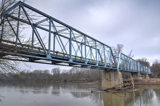
Jewettsport Ford Bridge
State Highway Bridge 4016

Primary Photographer(s): Nathan Holth
Bridge Documented: February 19, 2017
Near Battle Ground: Tippecanoe County, Indiana: United States
1912 By Builder/Contractor: Central States Bridge Company of Indianapolis, Indiana and Engineer/Design: Lafayette Engineering Company of Lafayette, Indiana
1989
158.0 Feet (48.2 Meters)
642.0 Feet (195.7 Meters)
14.4 Feet (4.39 Meters)
4 Main Span(s)
29150

View Information About HSR Ratings
Bridge Documentation
View Archived National Bridge Inventory Report - Has Additional Details and Evaluation
This bridge is in technical description fairly simple: a rivet-connected Pratt through truss. However as a single-lane bridge of substantial, four-span length it is unusual in the 21st Century for a one-lane bridge of this length over a major river to survive today. Its survival is in part due to low traffic volumes. Additionally, a well-designed stoplight signal system controls traffic over the bridge. The signals ensure safety, and vehicle detectors ensure that nobody has to wait at the signal for long if no cars are coming. The bridge is therefore an outstanding example of preservation.
Information and Findings From DHPA Historic Bridge SurveyStatement of Significance The Jewetts Port Ferry carried travelers across the Wabash River between Battle Ground and Prophets Town to Lafayette at least as early as the 1870s. The ferry operated until 1912 when the current bridge was constructed. The thoroughfare was sufficiently important to be incorporated into the state highway system later in the twentieth century. In 1911, the Tippecanoe county commissioners hired Everett B. Vawter to draft plans for bridges at Jewettsport and Davis Ferries, in December paid him $1,000 for his work, and in the following February adopted his proposed plans. The board set letting for March 1912, at which point it received a number of bids on the county and two alternative plans--one in steel by the Lafayette Engineering Co. and one in concrete by Daniel Luten. The board accepted both alternative plans and then awarded a contract to the lowest bidder, Lafayette Engineering on its own plan for $51,735. Lafayette Engineering's plan followed Vawter's proposed structure of four 158-ft. spans for a total structure length of 632 ft. Where Vawter designed for 2,100 lbs. of dead load and 1,600 lbs. of live load per lineal foot, Lafayette Engineering probably planned--as they did at Davis Ferry--for lower loads. Each of Lafayette's all-riveted, full-hip, Pratt through-trusses has a depth of 24 ft. and is subdivided into eight panels. The end-posts and top-chord members were fabricated from a pair of 12-in. channels (@20.5#), cover plate (16"x5/16"), and battens. The two pairs of angles used in the lower-chord members are the same (3'x3") for all but the center panel, where they are heavier. The truss webbing relies on connected angles. Laced double angles supply the verticals: the hip ones (2.5"x2.5") being lighter than the intermediate ones (5"x3"). Angles riveted together with stay plates provide the diagonals and decrease in size toward midspan (from 6"x3.5" to 3"x2.5"). The two central panels are countered with angles. The trusses are stiffened with braced-A portal struts; laced intermediate ones with knee braces; plus angle upper and lower lateral bracing. Riveted to the verticals above the lower chord, 20-in. I floor-beams (@65#) support four lines rows of 10-in. I beam stringers (@30#). Together the beams and stringers carry the 16-ft. concrete roadway. Latticed railings line the trusses. The Jewettsport Bridge, which still carries vehicular traffic across a long-standing, historically- significant crossing of the Wabash, is the longest extant riveted Pratt structure in Indiana. The superstructure--unadorned except for functionally/decoratively laced struts and latticed guardrails--retains its original members. The design is fairly standard for an early riveted through- truss. Angles have replaced eyebars throughout, and floor-beams have been attached to the trusses above the lower chord. An important engineering firm revised the county's design for the structure and constructed the bridge. Other Information References Indiana State Highway Commission, Structure #225-79-4016; Inventory of Bridges on State Highway System of Indiana (Indianapolis, 1979, 1983). Everett B. Vawter, Jewettsport Ford Bridge (5 February 1912), Tippecanoe County Bridge Drawings , Tippecanoe County Historical Society. Tippecanoe County Highway Department, Plan and Profile Showing Painting Surface of the Jewettsport Bridge; Bridge Plans: Jewettsport Bridge. Tippecanoe County, "Commissioners Record," 30: 409, 449, 485-488; 31: 91, 95-96; 34: 338, 352. "Construction News," Engineering News-Record, 67: 171. Bridge Considered Historic By Survey: Yes |
![]()
Photo Galleries and Videos: Jewettsport Ford Bridge
Bridge Photo-Documentation
Original / Full Size PhotosA collection of overview and detail photos. This gallery offers photos in the highest available resolution and file size in a touch-friendly popup viewer.
Alternatively, Browse Without Using Viewer
![]()
Bridge Photo-Documentation
Mobile Optimized PhotosA collection of overview and detail photos. This gallery features data-friendly, fast-loading photos in a touch-friendly popup viewer.
Alternatively, Browse Without Using Viewer
![]()
Maps and Links: Jewettsport Ford Bridge
Coordinates (Latitude, Longitude):
Search For Additional Bridge Listings:
Bridgehunter.com: View listed bridges within 0.5 miles (0.8 kilometers) of this bridge.
Bridgehunter.com: View listed bridges within 10 miles (16 kilometers) of this bridge.
Additional Maps:
Google Streetview (If Available)
GeoHack (Additional Links and Coordinates)
Apple Maps (Via DuckDuckGo Search)
Apple Maps (Apple devices only)
Android: Open Location In Your Map or GPS App
Flickr Gallery (Find Nearby Photos)
Wikimedia Commons (Find Nearby Photos)
Directions Via Sygic For Android
Directions Via Sygic For iOS and Android Dolphin Browser
USGS National Map (United States Only)
Historical USGS Topo Maps (United States Only)
Historic Aerials (United States Only)
CalTopo Maps (United States Only)

