

View Information About HSR Ratings
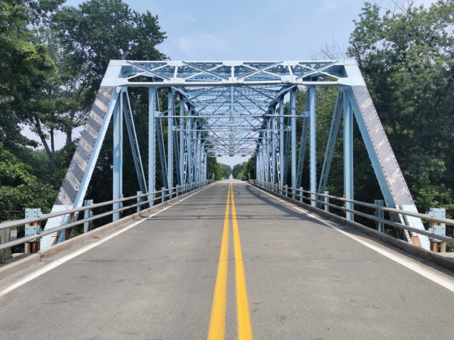
This is one of two basically identical historic state standard through truss bridges found on this stretch of road, both crossing the same river. The bridge construction was begun in 1941, but World War II halted construction and the two bridges were not completed until 1948.
Information and Findings From DHPA Historic Bridge Survey (For Both IN-256 Bridges)Bridge History and Significance The state inherited a three-span structure from the county. It consisted of an I-beam approach at each end seated on concrete abutments and on metal-caisson piers. An eight-panel, Pratt through-truss span with a horizontal truss bracing rod provided the center span. The county structure crossed the Muscatatuck about 65-feet upstream from the state bridge surveyed. In June 1941, the state contracted with R. P. Olinger of Huntingburg, Indiana, for a nearly identical pair of three-span structures over the same river and on the same road about three miles apart. Olinger bid $55,851.17 to build the structure in Jackson county, almost nine thousand dollars less than for the twin. The less expensive twin replaced a Jackson county structure located about 65 ft. downstream. The county structure consisted of a Pratt through-truss span seated on caisson piers and flanked by an I-beam approach span on each end. The state's plan called for a 50-ft. I-beam approach span at each end of a through truss. The Second World War intervened before Olinger completed neither of the Muscatatuck crossings, and so replacement construction was postponed until the war's end. The ISHC had the structures rebid in 1947, contracting in August with the Ben Hur Construction Company of Indianapolis for $154,447.33 for both of the twin structures. Hur Construction completed construction by May 1948. The ISHC used revised versions of the third-generation standard plan #475A for a 175-ft., riveted, Parker through-truss span with a 24-ft. roadway for the main span of this and for a dozen other structures. Truss depth varied from 21 ft. 6 in. at the portal to 31 ft. 6 in. at midspan. Each truss carried ten 17-ft. 6-in. panels. Every top chord member is differently sloped; none is parallel with the lower chord; and all were fabricated from a pair of 15-in. channels (@40# for the endposts, fourth, and fifth panels, and @33.3# for the second and third). Two pairs of angles--all of the same size (6"x4"Ls)--riveted together with battens and buttressed in all but the two most outer panels with plates provide the lower chord's members. The truss webbing is also substantial. The verticals or posts, except for the hip one, consist of a pair of laced 10-in. channels (@15.3#). A 10-in. I (@39#) supplied the hip vertical. To protect the quite-tall trusses against wind and vehicle-induced stress, the verticals are buttressed with substantial latticed struts and heavy upper sway framing above the 15 ft. of roadway clearance. The portals used latticed sections, too. The diagonals combined a pair of angles with battens into heavier members in the outer panels (6"x4"Ls) than in the central ones (3.5"x3"Ls). A pair of angles (3"x3"Ls) and battens provide counters in the two most central panels. The ISHC used 33-in. I floor-beams (@141#) riveted to the verticals above the lower chord. Eight rows of heavy rolled I stringers (16"@36#) are attached to the floor-beams' sides. Together, the floor-beams and the stringers carry the concrete deck. A pair of angles supplies each lower sway-bracing member. Post-and-channel rails lined the inner sides of the trusses, and coped concrete rails with bush-hammered panels marked the approaches. The superstructure sits upon state-designed concrete piers and abutments. This bridge exemplifies a belated use of a revised third-generation standard plan that served as an ISHC workhorse. The trusses retain their original members. The original truss' guard rails, the coped concrete approach-span rails with bush-hammered panels, and the concrete deck have all been replaced. References Indiana State Highway Commission, Structure #256-C-3370; Contract # 2173 (1941) & #2834 (1947); Superstructure Standard #475A; Inventory of Bridges on State Highway System of Indiana (Indianapolis, 1989). Bridge Considered Historic By Survey: Yes |
![]()
![]()
![]()
Coordinates (Latitude, Longitude):
Search For Additional Bridge Listings:
Bridgehunter.com: View listed bridges within 0.5 miles (0.8 kilometers) of this bridge.
Bridgehunter.com: View listed bridges within 10 miles (16 kilometers) of this bridge.
Additional Maps:
Google Streetview (If Available)
GeoHack (Additional Links and Coordinates)
Apple Maps (Via DuckDuckGo Search)
Apple Maps (Apple devices only)
Android: Open Location In Your Map or GPS App
Flickr Gallery (Find Nearby Photos)
Wikimedia Commons (Find Nearby Photos)
Directions Via Sygic For Android
Directions Via Sygic For iOS and Android Dolphin Browser
USGS National Map (United States Only)
Historical USGS Topo Maps (United States Only)
Historic Aerials (United States Only)
CalTopo Maps (United States Only)

© Copyright 2003-2025, HistoricBridges.org. All Rights Reserved. Disclaimer: HistoricBridges.org is a volunteer group of private citizens. HistoricBridges.org is NOT a government agency, does not represent or work with any governmental agencies, nor is it in any way associated with any government agency or any non-profit organization. While we strive for accuracy in our factual content, HistoricBridges.org offers no guarantee of accuracy. Information is provided "as is" without warranty of any kind, either expressed or implied. Information could include technical inaccuracies or errors of omission. Opinions and commentary are the opinions of the respective HistoricBridges.org member who made them and do not necessarily represent the views of anyone else, including any outside photographers whose images may appear on the page in which the commentary appears. HistoricBridges.org does not bear any responsibility for any consequences resulting from the use of this or any other HistoricBridges.org information. Owners and users of bridges have the responsibility of correctly following all applicable laws, rules, and regulations, regardless of any HistoricBridges.org information.
![]()