

View Information About HSR Ratings
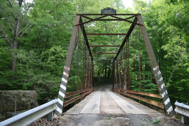
This bridge is a traditionally composed example of its type. Built in the later part of the pin-connected truss bridge era, it shows the final conclusion of all the experimentation and creativity that occurred in the late 1800s, which is that of standardization as bridge builders found the design and parts that were the best suited for the job.
This bridge is in fair condition, but is in need of a comprehensive rehabilitation to make sure it can continue to serve light rural traffic for decades to come.
Information and Findings From DHPA Historic Bridge SurveyStatement of Significance Built by a prolific Hoosier firm, this unadorned structure retains its original members, although the I beams welded to the floor beam bottoms and the concrete caps around the southern endposts suggest contemporary modifications for support. Architectural Description The Lafayette Bridge Company of Lafayette, Indiana, fabricated this single-span, pin-connected Pratt through truss which is seated upon cut stone abutments and wingwalls. Intermediate verticals of laced channels divide the 99' span into most of its six panels. Eyebars provide the diagonals: pairs stretch toward center span from the top panel point to the bottom of all except the endpost panels; cylindrical eyebars with turnbuckles counter the others in the two most central panels. U-bolted to the lower pins, I floor beams carry the timber deck with its 11'5" roadway and 16' of vertical clearance. ALTERATIONS: The I beams welded to the floor beam bottoms and the concrete caps around the southern endposts suggest contemporary modifications for support. Other Information This bridge was part of a 4-bridge combination contract negotiated for $3,300 in June 1897 with the Lafayette Bridge Company. One of the structures was to be 100-feet long and to carry a 12-foot roadway. In November, Lafayette Bridge received a $1,300 payment for two bridges in Guthrie township, one of which was over Guthrie Creek. Bridge Considered Historic By Survey: Yes |
![]()
![]()
![]()

![]()
Coordinates (Latitude, Longitude):
Search For Additional Bridge Listings:
Bridgehunter.com: View listed bridges within 0.5 miles (0.8 kilometers) of this bridge.
Bridgehunter.com: View listed bridges within 10 miles (16 kilometers) of this bridge.
Additional Maps:
Google Streetview (If Available)
GeoHack (Additional Links and Coordinates)
Apple Maps (Via DuckDuckGo Search)
Apple Maps (Apple devices only)
Android: Open Location In Your Map or GPS App
Flickr Gallery (Find Nearby Photos)
Wikimedia Commons (Find Nearby Photos)
Directions Via Sygic For Android
Directions Via Sygic For iOS and Android Dolphin Browser
USGS National Map (United States Only)
Historical USGS Topo Maps (United States Only)
Historic Aerials (United States Only)
CalTopo Maps (United States Only)

© Copyright 2003-2024, HistoricBridges.org. All Rights Reserved. Disclaimer: HistoricBridges.org is a volunteer group of private citizens. HistoricBridges.org is NOT a government agency, does not represent or work with any governmental agencies, nor is it in any way associated with any government agency or any non-profit organization. While we strive for accuracy in our factual content, HistoricBridges.org offers no guarantee of accuracy. Information is provided "as is" without warranty of any kind, either expressed or implied. Information could include technical inaccuracies or errors of omission. Opinions and commentary are the opinions of the respective HistoricBridges.org member who made them and do not necessarily represent the views of anyone else, including any outside photographers whose images may appear on the page in which the commentary appears. HistoricBridges.org does not bear any responsibility for any consequences resulting from the use of this or any other HistoricBridges.org information. Owners and users of bridges have the responsibility of correctly following all applicable laws, rules, and regulations, regardless of any HistoricBridges.org information.
![]()