

View Information About HSR Ratings
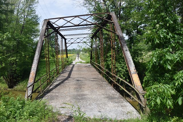
This is one of the youngest known surviving pin-connected truss highway bridges. Indeed if it were not for the research and documentation associated wtih this construction date and someone tried to date the bridge based on style alone, the bridge has the appearance of a ca. 1905 bridge. It is unclear why a pin-connected truss bridge was built here instead of a rivet-connected truss or a concrete bridge, both of which were well-established bridge technologies by this time. The design was specified by the county. This bridge is also noted as a rare skewed pin-connected truss.
Information and Findings From DHPA Historic Bridge SurveyBridge History and Significance The dredging of Birch Creek as Heck Ditch towards the end of the second decade of the 20th century deepened the waterway's channel and increased the distance from bank to bank. The improvement necessarily affected the crossings of the creek, leading to the moving of bridges, the adding of spans to some structures, and the building of other new ones. Andrew J. Jeffers and others in the Perry township neighborhood petitioned the Clay county commissioners in January 1926 for the construction of a new bridge across Birch Creek to replace one the citizens considered "unsafe for the public travel." The commissioners ordered the county surveyor, Oscar J. Jenkins, to prepare specifications and plans for a new bridge. After approving Jenkins proposals, the board set the letting for July at which time the Vincennes Bridge Company brought in "the lowest and best" bid at $4,795. The structure was satisfactorily completed by October to Jenkins' specific plan. Offset about 10% from one another, the trusses of this pin-connected, Pratt through-truss span rest upon concrete abutments and wingwalls. The 18-ft. high trusses extend 90 ft. in five panels. A pair of laced 5-in. channels provide each set of intermediate verticals, and a pair of 3"x2"Ls hang at the hips. All the diagonals and counters are die-forged eye-bars: In the second and fourth panels, a pair of 2"x3/4"; in the third panel, a 1.2-in. round rod with a turnbuckle provides a diagonal and a counter. Instead of the traditional Vincennes A-frame portal bracing, Jenkins specified a latticed strut with bracing. The interior struts are laced. Jenkins ordered 18-in. rolled I floor-beams attached (bolted) to pin plates. As Jenkins also specified, the bridge carries a concrete deck with a 16-ft. roadway and 17 ft. 2 in. of vertical clearance. Angle railings line the trusses. This crossing of Birch Creek had been used since before the Civil War, and it was bridged earlier, probably at the end of the 19th century. Aside from the skew, the design of the extant Pratt is rather standard for a pinned structure. It is, however, unusual for a county surveyor to actually prepare the plan used. Built by a notable Hoosier fabricator, the bridge retains its original members, including its latticed portals. References Beam, Longest & Neff, Inc., Bridge Inventory Rating and Safety Inspection: Clay County (Indianapolis, 1973, 1979). Clay County, "Commissioners Record," 14: 368; 16: 127; 19: 555; 31: 607, 707-708; 32: 17-20. Clay County, "Index to Commissioners Record," 23: 152. Clay County, Bridge Papers: F-K (Auditor's Office, wall files). Bridge Considered Historic By Survey: Yes (Select) |
![]()
![]()
![]()
Coordinates (Latitude, Longitude):
Search For Additional Bridge Listings:
Bridgehunter.com: View listed bridges within 0.5 miles (0.8 kilometers) of this bridge.
Bridgehunter.com: View listed bridges within 10 miles (16 kilometers) of this bridge.
Additional Maps:
Google Streetview (If Available)
GeoHack (Additional Links and Coordinates)
Apple Maps (Via DuckDuckGo Search)
Apple Maps (Apple devices only)
Android: Open Location In Your Map or GPS App
Flickr Gallery (Find Nearby Photos)
Wikimedia Commons (Find Nearby Photos)
Directions Via Sygic For Android
Directions Via Sygic For iOS and Android Dolphin Browser
USGS National Map (United States Only)
Historical USGS Topo Maps (United States Only)
Historic Aerials (United States Only)
CalTopo Maps (United States Only)

© Copyright 2003-2024, HistoricBridges.org. All Rights Reserved. Disclaimer: HistoricBridges.org is a volunteer group of private citizens. HistoricBridges.org is NOT a government agency, does not represent or work with any governmental agencies, nor is it in any way associated with any government agency or any non-profit organization. While we strive for accuracy in our factual content, HistoricBridges.org offers no guarantee of accuracy. Information is provided "as is" without warranty of any kind, either expressed or implied. Information could include technical inaccuracies or errors of omission. Opinions and commentary are the opinions of the respective HistoricBridges.org member who made them and do not necessarily represent the views of anyone else, including any outside photographers whose images may appear on the page in which the commentary appears. HistoricBridges.org does not bear any responsibility for any consequences resulting from the use of this or any other HistoricBridges.org information. Owners and users of bridges have the responsibility of correctly following all applicable laws, rules, and regulations, regardless of any HistoricBridges.org information.
![]()