

View Information About HSR Ratings
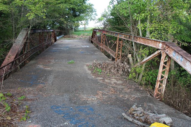
This is an abandoned ca. 1909 pony truss with pin connections and is noted for its skew. Commisioner names are written into the concrete abutment wingwalls, and Cambria steel brands are found on the truss.
Information and Findings From DHPA Historic Bridge SurveyBridge History and Significance The pinned trusses of the single-span, full-hip Pratt pony sit upon concrete abutments and wingwalls. Its verticals are made from two pairs of laced angles riveted to pin-plates above. A pair of rectangular eyebars provide the diagonals for the second and fourth of the 15'3" panels. A round rod with turnbuckles supplies the center panel's diagonal and counter. Only the center panel is countered. Bolted to the verticals above the lower chord, I-floor-beams carry a concrete deck and 15'9" roadway. Latticed guardrails protect the trusses. The design of this bridge suggests some transition between patterns. The webbing is pinned to the top chord, but the floor-beams are bolted above the lower chord. While full-hip Pratt ponies are not common, this design decision is an understandable accommodation to two other noteworthy features in this bridge--the unusually deep skew and the span length. The span retains all its original members, including the decorated guardrails. Vanderburgh County Surveyor's Office, Bridge Inspection Survey and Report: Vanderburgh County (Evansville, 1973).Sieco, Inc., Bridge Inspection Report: Vanderburgh County (Columbus, 1979). Floyd E. Burroughs, Bridge Reinspection Report: Vanderburgh County (Indianapolis, 1987). United Consulting Engineers, Bridge Reinspection Report: Vanderburgh County (Indianapolis, 1995). Bridge Considered Historic By Survey: Yes |
This bridge is tagged with the following special condition(s): Unorganized Photos
![]()
![]()
![]()
Coordinates (Latitude, Longitude):
Search For Additional Bridge Listings:
Bridgehunter.com: View listed bridges within 0.5 miles (0.8 kilometers) of this bridge.
Bridgehunter.com: View listed bridges within 10 miles (16 kilometers) of this bridge.
Additional Maps:
Google Streetview (If Available)
GeoHack (Additional Links and Coordinates)
Apple Maps (Via DuckDuckGo Search)
Apple Maps (Apple devices only)
Android: Open Location In Your Map or GPS App
Flickr Gallery (Find Nearby Photos)
Wikimedia Commons (Find Nearby Photos)
Directions Via Sygic For Android
Directions Via Sygic For iOS and Android Dolphin Browser
USGS National Map (United States Only)
Historical USGS Topo Maps (United States Only)
Historic Aerials (United States Only)
CalTopo Maps (United States Only)

© Copyright 2003-2024, HistoricBridges.org. All Rights Reserved. Disclaimer: HistoricBridges.org is a volunteer group of private citizens. HistoricBridges.org is NOT a government agency, does not represent or work with any governmental agencies, nor is it in any way associated with any government agency or any non-profit organization. While we strive for accuracy in our factual content, HistoricBridges.org offers no guarantee of accuracy. Information is provided "as is" without warranty of any kind, either expressed or implied. Information could include technical inaccuracies or errors of omission. Opinions and commentary are the opinions of the respective HistoricBridges.org member who made them and do not necessarily represent the views of anyone else, including any outside photographers whose images may appear on the page in which the commentary appears. HistoricBridges.org does not bear any responsibility for any consequences resulting from the use of this or any other HistoricBridges.org information. Owners and users of bridges have the responsibility of correctly following all applicable laws, rules, and regulations, regardless of any HistoricBridges.org information.
![]()