

View Information About HSR Ratings
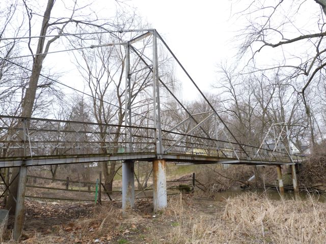
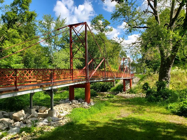
This extremely rare and highly unusual bridge is the only one of its kind in Indiana. Although it looks somewhat like a cantilever truss bridge, engineer Jim Barker, who designed the 2022 rehabilitation of the bridge, indicates that the bridge functions as a suspension bridge, despite the fact that it does not have a curved main cable design. The bridge is configured with unloaded backstays. This section of the bridge is supported by steel bents. The DHPA states that these bents are added, but if they are added, they are very old (they are riveted) and it is not clear what would have supported this deck if those bents were ever not in place. It certainly was not the anchor arm, there is no way it could have connected to support the deck.
Jim Barker also added that this bridge's design is similar to a long-lost bridge in Pittsburgh, the Point Bridge.
There are outriggers that appear to have been added to the bridge. There also are other welded alterations including some rather unusual ones on the towers suggesting a whole section of the tower was replaced. Otherwise, this bridge retains good historic integrity including original railings.
As stated above, in 2022 this bridge had a major rehabilitation, so it has a bright future.
Information and Findings From DHPA Historic Bridge SurveyStatement of Significance Built by a prolific Hoosier firm, this local landmark has linked the eastside residential area with downtown Plymouth for more than eight decades. The 1898 decision to restrict this crossing to pedestrians must have reinforced the residential character of the immediate neighborhood. The structure's design is both simple and unique in Indiana. The bridge appears to retain its original members, including its latticed guardrails. The whole has been reinforced by a series of piers. Architectural Description A petition in the summer of 1898 from local residents to replace the bridge at this site led the Plymouth Common Council to an unusual decision: to erect a through truss for vehicular traffic at Taylor (Garro) St. and build a pedestrian crossing at E. LaPorte Street. W. B. Bassett, agent for the Rochester Bridge Company of Rochester, Indiana, secured the contract for the two bridges which were subsequently constructed at the same time and completed by December 1898. The 100' structure consists of two approximately 20' high verticals fabricated from pairs of laced angles embedded in caissons. Angles set inward at 45 degrees to the tower-verticals are bolted from the tower top to the lower chord; they are counterbalanced by pinned, adjustable cylindrical eyebars also set at 45 degrees and which extend outward to where the lower chord and the concrete abutments meet; and thus the whole consists of two cantilevered kingpost spans joined through an extension of their I-beam lower chords. The inner panel of the longest kingpost has been subdivided to make the top chord more rigid. Designers added a diagonal from the bottom of the pier-tower to the middle of the top chord and an adjoining vertical of a pair of angles. The lower chord supports a 6' timber deck. Extra I beams set in concrete have been added as piers at several points. Alterations The bridge has been reinforced by a series of piers. Bridge Considered Historic By Survey: Yes |
![]()
![]()
![]()
![]()
![]()
Coordinates (Latitude, Longitude):
Search For Additional Bridge Listings:
Bridgehunter.com: View listed bridges within 0.5 miles (0.8 kilometers) of this bridge.
Bridgehunter.com: View listed bridges within 10 miles (16 kilometers) of this bridge.
Additional Maps:
Google Streetview (If Available)
GeoHack (Additional Links and Coordinates)
Apple Maps (Via DuckDuckGo Search)
Apple Maps (Apple devices only)
Android: Open Location In Your Map or GPS App
Flickr Gallery (Find Nearby Photos)
Wikimedia Commons (Find Nearby Photos)
Directions Via Sygic For Android
Directions Via Sygic For iOS and Android Dolphin Browser
USGS National Map (United States Only)
Historical USGS Topo Maps (United States Only)
Historic Aerials (United States Only)
CalTopo Maps (United States Only)

© Copyright 2003-2024, HistoricBridges.org. All Rights Reserved. Disclaimer: HistoricBridges.org is a volunteer group of private citizens. HistoricBridges.org is NOT a government agency, does not represent or work with any governmental agencies, nor is it in any way associated with any government agency or any non-profit organization. While we strive for accuracy in our factual content, HistoricBridges.org offers no guarantee of accuracy. Information is provided "as is" without warranty of any kind, either expressed or implied. Information could include technical inaccuracies or errors of omission. Opinions and commentary are the opinions of the respective HistoricBridges.org member who made them and do not necessarily represent the views of anyone else, including any outside photographers whose images may appear on the page in which the commentary appears. HistoricBridges.org does not bear any responsibility for any consequences resulting from the use of this or any other HistoricBridges.org information. Owners and users of bridges have the responsibility of correctly following all applicable laws, rules, and regulations, regardless of any HistoricBridges.org information.
![]()