

View Information About HSR Ratings
This riveted truss bridge was relocated here many decades ago.
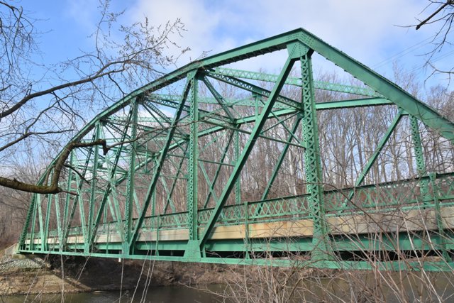
Information and Findings From DHPA Historic Bridge SurveyCurrent Structure In April 1931, E. R. Campbell of Sandborn, Indiana, bid $10,622.89 to build a Parker through-truss span seated on concrete abutments, all of state design, on US#24 over Hoagland Ditch in White County (#24-D-911). The ISHC used second-generation standard plan #422 for a number of these 150-foot, riveted, Parkers with 22-foot roadways. Truss depth varied from 21 feet and 6 inches at the portal to 29 feet and 6 inches at midspan. Each truss carried eight 18-foot and 9-inch panels. Both top and bottom chord members become heftier toward midspan. All top chord members were differently sloped; none was parallel with the lower chord. All were fabricated from a pair of 12-inch channels which increased in weight from 25-30 lbs. The lower chord members consisted of pairs of angles and battens. While all of the same size (6"x4"Ls) and riveted together with battens, the outermost two panels rely on a single pair of angles, while the others use two pairs. Each of the verticals was made of a pair of laced 8-inch channels (@11.5#, except for the hip ones @13.75#). To protect the quite-tall trusses against wind and vehicle-induced stress, substantial latticed struts and heavy upper sway framing buttressed the verticals above the 15 feet of roadway clearance. The portals relied on laced rather than latticed sections. The diagonals combined a pair of angles with battens into heavier members in the outer panels than toward center: in the second and third panels, 6x3.5-inch angles; in the fourth, 4x3-inch angles. The two most central panels carried a pair of 3x3-inch angles as counters. The state ordered 33-inch I floor-beams (@125#) riveted to the verticals above the lower chord. Eight rows of rolled I stringers (16"@35#) are attached to the floor-beams' sides. Together, the floor-beams and the stringers carry the concrete deck. A pair of angles supplies each lower sway-bracing member. Latticed guardrails line the trusses. When the ISHC replaced the Parker on U. S. #24 with a wider three-span concrete structure in 1968, the old steel span was dismantled, sold to Carroll County, and re-erected on Prince William Road just south of the old metal-truss Xenia Bridge. Except for being bolted together rather than riveted--a consequence of the move to Carroll County--the replacement span carries all the hallmarks of its ISHC paternity. The moved span sits on concrete abutments anchored by timber piles and carries a new concrete roadway. The Xenia Bridge is the only example extant of this second-generation ISHC standard plan and therefore has the oldest surviving 150-foot Parker through-trusses of state design. Moving altered the system of connection, and required a new substructure and deck. Still, the trusses appear to retain their original members along with their latticed guardrails. Previous Structure A structure earlier than the extant one probably carried Prince William Road over Wildcat Creek. The old concrete abutment which remains to the north demarks one end of a previous structure. In May 1898, S. H. Godman, then agent of the Wabash Bridge and Iron Company, received a contract from the county commissioners for new steel joists or stringers for a bridge here. This arrangement suggests the presence of an older iron-truss structure with timber stringers. It was probably this bridge which the county replaced in 1968 with a second-hand state highway span from White County. Other Information References Indiana State Highway Commission, Structure, #24-D-911; Contract, #402; Superstructure Standard, #422. Charles J. Ritzler, Bridge Inspection Report: Carroll County (Delphi, 1974-75). AECON, Inc. , Bridge Reinspection Study & Report: Carroll County (Nashville, 1987). Rumschlag Technical Services, Carroll County Bridge Inventory & Appraisal Report (Brownsburg, 2006). Carroll County, "Commissioners Record," 19: 555. Bridge Considered Historic By Survey: Yes |
![]()
![]()
![]()
Coordinates (Latitude, Longitude):
Search For Additional Bridge Listings:
Bridgehunter.com: View listed bridges within 0.5 miles (0.8 kilometers) of this bridge.
Bridgehunter.com: View listed bridges within 10 miles (16 kilometers) of this bridge.
Additional Maps:
Google Streetview (If Available)
GeoHack (Additional Links and Coordinates)
Apple Maps (Via DuckDuckGo Search)
Apple Maps (Apple devices only)
Android: Open Location In Your Map or GPS App
Flickr Gallery (Find Nearby Photos)
Wikimedia Commons (Find Nearby Photos)
Directions Via Sygic For Android
Directions Via Sygic For iOS and Android Dolphin Browser
USGS National Map (United States Only)
Historical USGS Topo Maps (United States Only)
Historic Aerials (United States Only)
CalTopo Maps (United States Only)

© Copyright 2003-2025, HistoricBridges.org. All Rights Reserved. Disclaimer: HistoricBridges.org is a volunteer group of private citizens. HistoricBridges.org is NOT a government agency, does not represent or work with any governmental agencies, nor is it in any way associated with any government agency or any non-profit organization. While we strive for accuracy in our factual content, HistoricBridges.org offers no guarantee of accuracy. Information is provided "as is" without warranty of any kind, either expressed or implied. Information could include technical inaccuracies or errors of omission. Opinions and commentary are the opinions of the respective HistoricBridges.org member who made them and do not necessarily represent the views of anyone else, including any outside photographers whose images may appear on the page in which the commentary appears. HistoricBridges.org does not bear any responsibility for any consequences resulting from the use of this or any other HistoricBridges.org information. Owners and users of bridges have the responsibility of correctly following all applicable laws, rules, and regulations, regardless of any HistoricBridges.org information.
![]()