We Recommend:
Bach Steel - Experts at historic truss bridge restoration.
Pugh Ford Bridge
Bartholomew County Bridge 73, Hoot Owl Hollar Bridge, Pence Bridge

Primary Photographer(s): Nathan Holth and Rick McOmber
Bridge Documented: September 23, 2012
Rural: Bartholomew County, Indiana: United States
1911 By Builder/Contractor: Elkhart Bridge and Iron Company of Elkhart, Indiana
1997
126.6 Feet (38.6 Meters)
260.0 Feet (79.2 Meters)
15.4 Feet (4.69 Meters)
2 Main Span(s)
300068

View Information About HSR Ratings
Bridge Documentation
View Archived National Bridge Inventory Report - Has Additional Details and Evaluation
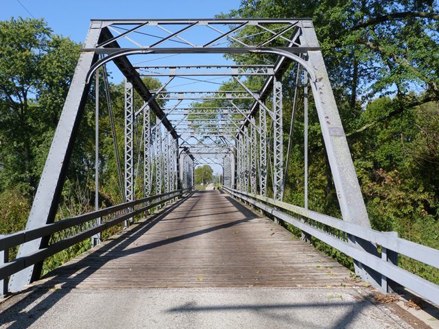
This bridge is a noteworthy example of a multi-span truss bridge and also as a bridge built by in-state bridge built Elkhart Bridge and Iron Company. However, one of the more fascinating aspects of this bridge is its history. The only visual clue of this history is subtle: the concrete abutments with a corbelled detail on the top, somewhat fancier than typical truss bridge abutments from this period. The story is that in 1909 a concrete arch bridge designed to a Daniel Luten patent was constructed at this location. Only a year later, this bridge was destroyed in a flood, which led the county to get into a legal battle with Luten. However, it turns out the county had tried to cut corners by not using any piling whatsoever in the substructure! Despite the fact that it was the county's fault that the bridge was destroyed, the county was not interested in trying it again the right way and instead insisted on a metal truss bridge replacement. One interesting note however was that when an engineer later reviewed the concrete abutments that were built for the truss bridge, it was found that they were substantially overbuilt with steel reinforcing, more than was called for in the plans. After cheating on the first attempt with concrete, it appears that the county did a complete turnaround and went above and beyond the requirements. The county was likely not taking any chances on the concrete abutments for the truss bridge, desperate to avoid a repeat of the previous disaster.
Information and Findings From DHPA Historic Bridge SurveyStatement of Significance The pin-connected trusses are of rather standard design. The spans retain their original members, including latticed guardrails. Architectural Description Seated upon a concrete pier, abutments, and wingwalls, this two-span, pin-connected Pratt through structure extends 256' in eight panels for each span. Laced channels provide the intermediate verticals, a pair of die-forged eyebars serve as diagonals, a pair of adjustable and cylindrical rods counter the diagonals in the three most central panels. The I floor beams are U-bolted to the lower pins. The bridge carries an asphalt and metal pan deck with a 16' roadway and 14'6" of vertical clearance. Other Information Previous Structure: The National Concrete Company constructed a Luten-design filled-spandrel arch here in 1911 which, when washed out, became a matter of contention between the contractor and the commissioners. Surveyed Structure: Luten and the National Concrete Company negotiated a settlement with the county in which National Concrete agreed to build abutments and pier for a new steel replacement bridge for the modest charge of $1,050. Luten and his associates also secured a special price from the Elkhart Bridge Company for the superstructure at $3,400. Contracts for the same were consummated in May 1911. H. C. Deist, a civil engineer charged to inspect the new substructure, reported in August "that the pier has been built better than the plans called for and that some steel was placed in abutments when no steel was specified." He also noted that the tops of the abutments were not as wide as the plans called for. Francis F. Gosch, the superintendent of construction of the Pugh Ford Bridge, reported that the substructure was "better and stronger than the plans called for." Seated upon the new concrete substructure, the trusses of the superstructure are each divided into eight panels by intermediate verticals of laced channels. A pair of die-forged eyebars serve as diagonals, a pair of adjustable and cylindrical rods counter the diagonals in the three most central panels. The bridge maintains 14 feet and 6 inches of vehicular clearance above the roadway. The I floor-beams, U-bolted to the lower pins, carry an asphalt and metal pan roadway. The pin-connected trusses are of rather standard design. The spans retain their original members, including latticed guardrails. Asphalt and metal pan deck replaced with timber by 1994 [SHPO database] Bridge Considered Historic By Survey: Yes |
![]()
Photo Galleries and Videos: Pugh Ford Bridge
Bridge Photo-Documentation
Original / Full Size PhotosA collection of overview and detail photos. This gallery offers photos in the highest available resolution and file size in a touch-friendly popup viewer.
Alternatively, Browse Without Using Viewer
![]()
Bridge Photo-Documentation
Mobile Optimized PhotosA collection of overview and detail photos. This gallery features data-friendly, fast-loading photos in a touch-friendly popup viewer.
Alternatively, Browse Without Using Viewer
![]()
Eastbound Crossing
Full Motion VideoStreaming video of the bridge. Also includes a higher quality downloadable video for greater clarity or offline viewing.
![]()
Maps and Links: Pugh Ford Bridge
Coordinates (Latitude, Longitude):
Search For Additional Bridge Listings:
Bridgehunter.com: View listed bridges within 0.5 miles (0.8 kilometers) of this bridge.
Bridgehunter.com: View listed bridges within 10 miles (16 kilometers) of this bridge.
Additional Maps:
Google Streetview (If Available)
GeoHack (Additional Links and Coordinates)
Apple Maps (Via DuckDuckGo Search)
Apple Maps (Apple devices only)
Android: Open Location In Your Map or GPS App
Flickr Gallery (Find Nearby Photos)
Wikimedia Commons (Find Nearby Photos)
Directions Via Sygic For Android
Directions Via Sygic For iOS and Android Dolphin Browser
USGS National Map (United States Only)
Historical USGS Topo Maps (United States Only)
Historic Aerials (United States Only)
CalTopo Maps (United States Only)


