

View Information About HSR Ratings
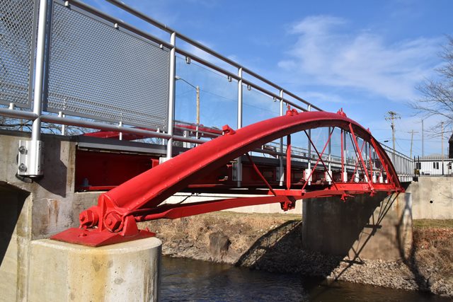
This relocated and preserved bridge is one of only a handful of rare Rezner patent bowstring bridges in the country. Please see the above linked report for a detailed history of this bridge.
Information and Findings From DHPA Historic Bridge SurveyStatement of Significance Gangloff-Sayler Farm Bridge, Hoover Slough Bridge (Possible historic name) Rezner Bowstring (1871 - 19xx) In April 1871, the Jasper county commissioners sought proposals for two more iron superstructures on "solid stone abutments." Both sites were on the Rensselaer and Remington Road - one at 60-feet over Big Slough at Alfred Hoover's and the other at 50-feet over Carpenter Creek at "Lipprant's crossing" about half a mile north of Remington, each to be 12- or 14-feet wide. William Rezner apparently came to Rensselaer in June to present the commissioners with the Ohio Wrought Iron Bridge Company of Cleveland's proposal. Theirs was the lowest and subsequently the successful bid for these bridge superstructures. William Hartshorn of Grant county won the contract for the two sets of stone abutments. The commissioners accepted both sets of abutments by late August, and Hartshorn received $2,309 for his stone work. In early September, the commissioners also accepted the two superstructures and paid the Ohio Wrought Iron Bridge Company $1,636.47 for the spans. Pratt Pony Truss (19xx - 19xx) The Indiana State Highway Commission sent a team to survey the bridges on the Rensselear-Remington Road in January 1928, including the two crossings discussed here. The state had incorporated this section of Jasper County roadway with its structures into State Route #53. In neither case did the state surveyors find a bowstring in place or located within one or two miles up or down stream or ditch from the relevant state highway crossing. The Carpenter Creek bowstring (S19-24/T27N/R6-7W) had been replaced by a 49-foot pinned Pratt pony-truss superstructure, in this case seated on the original bowstring's stone abutments. This would, indeed, confirm the county's recorded specifications for a 50-foot long bowstring there. Carpenter Creek had not been dredged. The replacement superstructure over Carpenter's Creek carried rectangular built-up girder floor-beams, more typical of late 19th- than of 20th-century design, but the 18-foot wide roadway points to the 20th century for Jasper County bridge design and construction. Other Information References James L. Cooper, "Potawatomi Park's Enduring Monument" (2013). Rezner Bowstring (1871 - 19xx) Jasper County, "Commissioners Record," 4: 37, 53, 57-58, 61, 67, 69, 77, 84, 86-89, 127. "Proceedings in Commissioners Court," The Rensselaer Union, 15 June 1871, p3 c5. Pratt Pony Truss (19xx - 19xx) Indiana State Highway Commission, "Bridge #202" survey book (1928), 59-79 (housed in the Records Division, INDOT, Indianapolis). Bridge Considered Historic By Survey: Yes |
![]()
![]()
![]()
Coordinates (Latitude, Longitude):
Search For Additional Bridge Listings:
Bridgehunter.com: View listed bridges within 0.5 miles (0.8 kilometers) of this bridge.
Bridgehunter.com: View listed bridges within 10 miles (16 kilometers) of this bridge.
Additional Maps:
Google Streetview (If Available)
GeoHack (Additional Links and Coordinates)
Apple Maps (Via DuckDuckGo Search)
Apple Maps (Apple devices only)
Android: Open Location In Your Map or GPS App
Flickr Gallery (Find Nearby Photos)
Wikimedia Commons (Find Nearby Photos)
Directions Via Sygic For Android
Directions Via Sygic For iOS and Android Dolphin Browser
USGS National Map (United States Only)
Historical USGS Topo Maps (United States Only)
Historic Aerials (United States Only)
CalTopo Maps (United States Only)

© Copyright 2003-2024, HistoricBridges.org. All Rights Reserved. Disclaimer: HistoricBridges.org is a volunteer group of private citizens. HistoricBridges.org is NOT a government agency, does not represent or work with any governmental agencies, nor is it in any way associated with any government agency or any non-profit organization. While we strive for accuracy in our factual content, HistoricBridges.org offers no guarantee of accuracy. Information is provided "as is" without warranty of any kind, either expressed or implied. Information could include technical inaccuracies or errors of omission. Opinions and commentary are the opinions of the respective HistoricBridges.org member who made them and do not necessarily represent the views of anyone else, including any outside photographers whose images may appear on the page in which the commentary appears. HistoricBridges.org does not bear any responsibility for any consequences resulting from the use of this or any other HistoricBridges.org information. Owners and users of bridges have the responsibility of correctly following all applicable laws, rules, and regulations, regardless of any HistoricBridges.org information.
![]()