

View Information About HSR Ratings
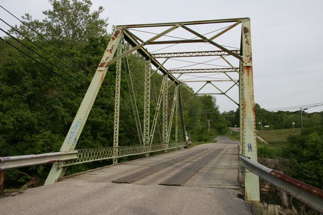
This bridge is a traditionally composed example of a riveted Pratt through truss, and it represents a relatively early example of a riveted connection truss bridge in Indiana. Serving local vehicular traffic, the bridge is located next to a busier highway such that many people can easily see and notice this bridge. While other older and more significant bridges remain in Lawrence County, this bridge has received a fair amount of public support and attention likely because of its high visibility. The bridge is in rather good condition and its preservation in the form of routine maintenance and repair should ensure that the bridge remains for decades to come.
The DHPA survey comments that the bridge is bolted. It is not a bolted connection bridge, it is instead a riveted connection bridge. A few rivets on the bridge were replaced with bolts on the connections, but this is not an original detail.
Information and Findings From DHPA Historic Bridge SurveyStatement of Significance Bolted Pratt through trusses are not plentiful in Indiana. The design of this structure is fairly standard. The bridge retains its original members, including latticed guardrails. Architectural Description Seated upon cut stone abutments and wingwalls, this largely-bolted Pratt through span extends 94'8" in five panels. A pair of laced channels provides each set of intermediate verticals, and a pair of angles riveted together with battens serves as diagonal and counter sets. Only the center panel is countered. The I floor beams are bolted to gussets below the lower chord. The bridge carries an asphalt-over-concrete deck with a 18'4" roadway and 18'6" of vertical clearance. Other Information Historically, this bridge carried traffic from Bedford to Tunnelton and was bypassed in 1970. The bridge is located outside Otis Park and Golf Course. Otis Park, listed in the National Register, was donated to the city by Fred B. Otis (editor of the Bedford Daily Mail) in 1935. Bridge Considered Historic By Survey: Yes |
![]()
![]()
![]()
Coordinates (Latitude, Longitude):
Search For Additional Bridge Listings:
Bridgehunter.com: View listed bridges within 0.5 miles (0.8 kilometers) of this bridge.
Bridgehunter.com: View listed bridges within 10 miles (16 kilometers) of this bridge.
Additional Maps:
Google Streetview (If Available)
GeoHack (Additional Links and Coordinates)
Apple Maps (Via DuckDuckGo Search)
Apple Maps (Apple devices only)
Android: Open Location In Your Map or GPS App
Flickr Gallery (Find Nearby Photos)
Wikimedia Commons (Find Nearby Photos)
Directions Via Sygic For Android
Directions Via Sygic For iOS and Android Dolphin Browser
USGS National Map (United States Only)
Historical USGS Topo Maps (United States Only)
Historic Aerials (United States Only)
CalTopo Maps (United States Only)

© Copyright 2003-2024, HistoricBridges.org. All Rights Reserved. Disclaimer: HistoricBridges.org is a volunteer group of private citizens. HistoricBridges.org is NOT a government agency, does not represent or work with any governmental agencies, nor is it in any way associated with any government agency or any non-profit organization. While we strive for accuracy in our factual content, HistoricBridges.org offers no guarantee of accuracy. Information is provided "as is" without warranty of any kind, either expressed or implied. Information could include technical inaccuracies or errors of omission. Opinions and commentary are the opinions of the respective HistoricBridges.org member who made them and do not necessarily represent the views of anyone else, including any outside photographers whose images may appear on the page in which the commentary appears. HistoricBridges.org does not bear any responsibility for any consequences resulting from the use of this or any other HistoricBridges.org information. Owners and users of bridges have the responsibility of correctly following all applicable laws, rules, and regulations, regardless of any HistoricBridges.org information.
![]()