

View Information About HSR Ratings
Bridge abandoned in 1968. Some sources report a 1902 construction date for this bridge, but it turns out that date actually refers to a Erie/C&CL/Nickel Plate bridge that was removed long ago. This swing bridge probably dates to the 1890s.
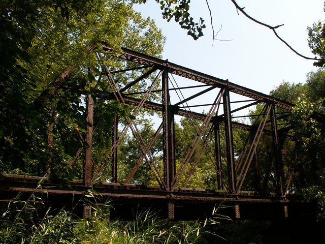
It generally takes a decent sized river to get a truss bridge to be on a railroad / river crossing. That is why the state of Michigan for example has few railroad truss bridges, since most of their rivers are smaller. Similarly, a river must be a certain size to transport larger boats thus requiring movable bridges. Given this, a multi-span movable truss bridge was absolutely the last thing you might expect to find on the Grand Calumet River, but yet movable bridges can be found on the river, although they no longer operate. The Grand Calumet River today is not "grand" in any sense of the word. It is the smallest width-wise of all three "Calumet" rivers, smaller in fact than the regular Calumet River and the Little Calumet River. The river is so small that many modern bridges crossing this river simply use culverts to cross it! The river is not very grand in that it is one of the most disgusting bodies of water around. The river is mostly composed of industrial runoff and has a greyish-green color! U.S. Steel at Gary used to dump toxic waste, including things like mercury other unpleasant things in it. Even today, it has 90% storm drain and industrial drainage to it, even if mercury is not going in it anymore. Anyway, it is one sick-looking river, and this bridge is one of the few things adding beauty to the river. The reason why there are movable bridges on the river is that once the river was wider and larger and could handle boats. The rivers in this area and where the waterways flow have vastly changed over the years, and in the case of the Grand Calumet River it simply isn't what it used to be. As a result, this bridge passes over considerable distance of dry land.
The bridge seen here is a full-size truss swing bridge with timber approaches. Most of the mechanics have long been removed, although the roller nest the bridge swung on is still present testifying to this bridge's movable past. Lattice is present on both sides of the top and bottom chords as well as the end posts. V-lacing can be found on the verticals. The structure in pin connected. The three-culvert crossing seen just east of this bridge on Sohl Avenue is a stark comparison of the former use of the Grand Calumet River as a navigable waterway to a small creek/ditch that it is today. The bridge was built ca. 1900.
Information and Findings From DHPA Historic Bridge SurveyStatement of Significance The designer of this structure appears to have followed Waddell's 1898 prescription of "pin-connected Pratt trusses with parallel top chords and stiff diagonals in panels where stress reversal occurs" for swing spans between 140 and 225 feet. By the early twentieth century the excessive wear at pin-points with swing spans became clear, and so riveted connections became common. The main span here appears to retain its original members except for its power source for turning. It is the only pinned swing span to have survived in Indiana. Architectural Description Affixed between two timber beam approaches at each end, the rim-bearing, pin-connected Pratt through swing span of twelve panels sits upon its masonry center pier. The endposts and chords are fabricated from latticed reinforced channels. The verticals are also made of laced channels which are heavier toward the center pier. Four die-forged eyebars angle outward from the top most central panel point toward each of the adjacent lower pins on the rim's edge; a pair angles outward from the other top pins and are countered by a pair of adjustable eyebars only in the two panels adjacent to each endpost. Rectangular girder floor-beams support the timber ties and a single track. References Paula Spero, Metal Truss Bridges in Virginia: 1865-1932 (Charlottesville, VA, 1978-), VIII, "The Suffolk Construction District," 13-14. Bridge Considered Historic By Survey: Yes |
![]()
![]()
![]()
Coordinates (Latitude, Longitude):
Search For Additional Bridge Listings:
Bridgehunter.com: View listed bridges within 0.5 miles (0.8 kilometers) of this bridge.
Bridgehunter.com: View listed bridges within 10 miles (16 kilometers) of this bridge.
Additional Maps:
Google Streetview (If Available)
GeoHack (Additional Links and Coordinates)
Apple Maps (Via DuckDuckGo Search)
Apple Maps (Apple devices only)
Android: Open Location In Your Map or GPS App
Flickr Gallery (Find Nearby Photos)
Wikimedia Commons (Find Nearby Photos)
Directions Via Sygic For Android
Directions Via Sygic For iOS and Android Dolphin Browser
USGS National Map (United States Only)
Historical USGS Topo Maps (United States Only)
Historic Aerials (United States Only)
CalTopo Maps (United States Only)

© Copyright 2003-2024, HistoricBridges.org. All Rights Reserved. Disclaimer: HistoricBridges.org is a volunteer group of private citizens. HistoricBridges.org is NOT a government agency, does not represent or work with any governmental agencies, nor is it in any way associated with any government agency or any non-profit organization. While we strive for accuracy in our factual content, HistoricBridges.org offers no guarantee of accuracy. Information is provided "as is" without warranty of any kind, either expressed or implied. Information could include technical inaccuracies or errors of omission. Opinions and commentary are the opinions of the respective HistoricBridges.org member who made them and do not necessarily represent the views of anyone else, including any outside photographers whose images may appear on the page in which the commentary appears. HistoricBridges.org does not bear any responsibility for any consequences resulting from the use of this or any other HistoricBridges.org information. Owners and users of bridges have the responsibility of correctly following all applicable laws, rules, and regulations, regardless of any HistoricBridges.org information.
![]()