

View Information About HSR Ratings
This bridge is oddly called Twin Bridge apparently because it is next to another bridge, a railroad bridge. However, the railroad bridge is about as far from a twin as you can get. It is a massive concrete railroad deck arch bridge, quite different from this lightweight metal truss highway bridge. This highway truss actually sits in the footprint of the previous railroad bridge, a metal truss whose stone abutment remains near to this bridge.
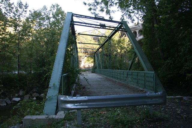
This bridge is noted as a very rare example of a pin-connected Baltimore highway truss bridge. It also is rare as a skewed pin-connected truss bridge. The bridge has been rehabilitated in place for pedestrian use. The bridge retains good historic integrity.
Information and Findings From DHPA Historic Bridge SurveyStatement of Significance One of two structures known to remain of this short-lived successor to the Indianapolis Bridge Co. and one of three Baltimore trusses surviving in Indiana, the bridge is unusual for its sub-struts and sub-ties, its skew, its sparing use of heavy verticals, its reliance on loop-welded cylindrical eyebars, and its length (longest Baltimore on highway system). The bridge retains its original members including its decoratively latticed portals and portal struts. It also differs from the other two Baltimores in its horizontal struts. This bridge and its 'twin', a 1906 open-spandrel concrete arch bridge which carried the Big Four Railroad, are an important asset to the community and have become part of the local culture and folklore. Architectural Description The Indiana Bridge Company of Indianapolis erected this 149'6" pin-connected Baltimore through span with patented features and with the west truss offset about 6' to the south upon cut stone abutments and wingwalls. An extensive use of sub-struts and sub-ties divides the span into the equivalent of twelve short panels of 12'5" each. The four most central panels are bounded by and alternate the three verticals of laced channels (of two sizes) used in the truss; all others are double eyebars. The diagonals, sub-struts, and sub-ties vary from die-forged to loop-welded eyebars some of which are adjustable. The endpost area is subdivided with an I beam diagonal. The main, double-intersecting diagonals consist of three die-forged eyebars one of which was adjustable. The truss also has an adjustable member parallel to and midway between the two chords across the four center panels which then stretches diagonally to the top chord-endpost connection. The heavy rectangular die-forged eyebars (three for the endpost panels; two otherwise) of the lower chord run through the intermediate panel points. Double U-bolted to pins below the lower chord, girder floor beams carry the timber deck with a 16'8" roadway and 17' of vertical clearance. Bridge Considered Historic By Survey: Yes |
![]()
![]()
![]()
Coordinates (Latitude, Longitude):
Search For Additional Bridge Listings:
Bridgehunter.com: View listed bridges within 0.5 miles (0.8 kilometers) of this bridge.
Bridgehunter.com: View listed bridges within 10 miles (16 kilometers) of this bridge.
Additional Maps:
Google Streetview (If Available)
GeoHack (Additional Links and Coordinates)
Apple Maps (Via DuckDuckGo Search)
Apple Maps (Apple devices only)
Android: Open Location In Your Map or GPS App
Flickr Gallery (Find Nearby Photos)
Wikimedia Commons (Find Nearby Photos)
Directions Via Sygic For Android
Directions Via Sygic For iOS and Android Dolphin Browser
USGS National Map (United States Only)
Historical USGS Topo Maps (United States Only)
Historic Aerials (United States Only)
CalTopo Maps (United States Only)

© Copyright 2003-2024, HistoricBridges.org. All Rights Reserved. Disclaimer: HistoricBridges.org is a volunteer group of private citizens. HistoricBridges.org is NOT a government agency, does not represent or work with any governmental agencies, nor is it in any way associated with any government agency or any non-profit organization. While we strive for accuracy in our factual content, HistoricBridges.org offers no guarantee of accuracy. Information is provided "as is" without warranty of any kind, either expressed or implied. Information could include technical inaccuracies or errors of omission. Opinions and commentary are the opinions of the respective HistoricBridges.org member who made them and do not necessarily represent the views of anyone else, including any outside photographers whose images may appear on the page in which the commentary appears. HistoricBridges.org does not bear any responsibility for any consequences resulting from the use of this or any other HistoricBridges.org information. Owners and users of bridges have the responsibility of correctly following all applicable laws, rules, and regulations, regardless of any HistoricBridges.org information.
![]()