

View Information About HSR Ratings
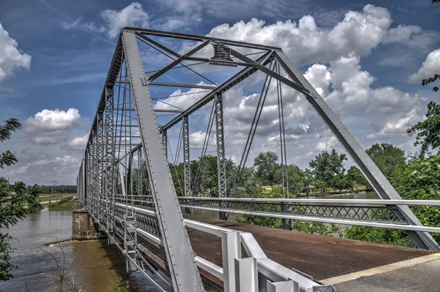
This pin connected truss bridge is noted for its relatively long three span configuration. The bridge has some unusual repairs, such as crudely welded plate on a bottom chord eyebar, and a vertical member replaced with a crudely designed replacement. These repairs appear to be older, and predate the most recent rehabilitation and repainting of the bridge.

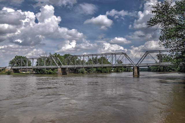
Information and Findings From DHPA Historic Bridge SurveyStatement of Significance The Indiana Bridge Company of Muncie, Indiana, fabricated this three-span, pin-connected Pratt through truss which is seated upon concrete abutments, wingwalls, and piers. Intermediate verticals of laced channels subdivide each 140' truss into most of its eight panels. Eyebars provide the diagonals: pairs of die-forged and rectangular ones stretch toward center span from the top panel point to the bottom of all except the endpost panels; cylindrical eyebars with turnbuckles counter the others in the two most central panels. Riveted to plates above the lower chord, I floor-beams carry the timber deck with its 15'5" roadway and 16' of vertical clearance. Daviess County officials contracted with Indiana Bridge for these spans. Built by a prolific Hoosier firm, these trusses retain their original members, including their decoratively latticed guardrails. The heavier-duty floor beam and endpost vertical connections illustrate a move away from standard pin design. References United Construction and Engineering Corporation, Bridge Inspection Study and Report: Knox County (Indianapolis, 1972). Associated Engineering Consultants, Bridge Reinspection Study and Report: Knox County (Nashville, 1977, 1981). United Consulting Engineers & Architects, Bridge Inventory Report: Knox County (Indianapolis, 2002). bridge nameplate. Indiana Bridge Company, Contract Index, #4948 & #4948 1/2, Indiana Bridge Co. (Muncie). Bridge Considered Historic By Survey: Yes |
![]()
![]()
![]()
Coordinates (Latitude, Longitude):
Search For Additional Bridge Listings:
Bridgehunter.com: View listed bridges within 0.5 miles (0.8 kilometers) of this bridge.
Bridgehunter.com: View listed bridges within 10 miles (16 kilometers) of this bridge.
Additional Maps:
Google Streetview (If Available)
GeoHack (Additional Links and Coordinates)
Apple Maps (Via DuckDuckGo Search)
Apple Maps (Apple devices only)
Android: Open Location In Your Map or GPS App
Flickr Gallery (Find Nearby Photos)
Wikimedia Commons (Find Nearby Photos)
Directions Via Sygic For Android
Directions Via Sygic For iOS and Android Dolphin Browser
USGS National Map (United States Only)
Historical USGS Topo Maps (United States Only)
Historic Aerials (United States Only)
CalTopo Maps (United States Only)

© Copyright 2003-2024, HistoricBridges.org. All Rights Reserved. Disclaimer: HistoricBridges.org is a volunteer group of private citizens. HistoricBridges.org is NOT a government agency, does not represent or work with any governmental agencies, nor is it in any way associated with any government agency or any non-profit organization. While we strive for accuracy in our factual content, HistoricBridges.org offers no guarantee of accuracy. Information is provided "as is" without warranty of any kind, either expressed or implied. Information could include technical inaccuracies or errors of omission. Opinions and commentary are the opinions of the respective HistoricBridges.org member who made them and do not necessarily represent the views of anyone else, including any outside photographers whose images may appear on the page in which the commentary appears. HistoricBridges.org does not bear any responsibility for any consequences resulting from the use of this or any other HistoricBridges.org information. Owners and users of bridges have the responsibility of correctly following all applicable laws, rules, and regulations, regardless of any HistoricBridges.org information.
![]()