

View Information About HSR Ratings
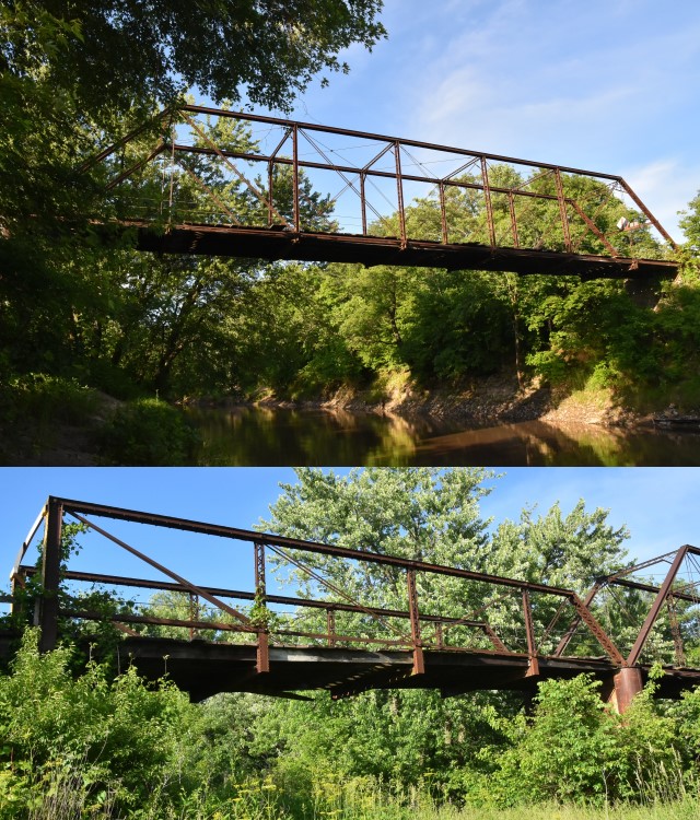
This bridge, constructed ca. 1882, is a very old surviving example of a Pratt truss bridge. Its lack of alteration and outstanding structural condition also set it apart from the dwindling crowd of wrought iron truss bridges. The most noteworthy and unique feature of this bridge however is actually found in its pony truss approach span, which has an inclined endpost at the eastern end, but a vertical bedstead style endpost at the western end. An unusual sloped bottom chord is also found on this span. From east to west, the bottom chord slowly rises above the deck to meet the vertical endpost a short distance above the deck.
As of the writing of this narrative, the only other bridge identified by HistoricBridges.org with a bedstead endpost at one end and an inclined endpost at the other end is a bridge in Tennessee.
This bridge's lack of alteration and lack of deterioration (due to being made of wrought iron) is truly remarkable. The one unfortunate problem on this bridge is that when it was open to traffic some of the vertical members were badly damaged by collision.
The easternmost floorbeam is not a built-up fishbelly floorbeam, suggesting it is a replacement.
Daniel and Webster of Garden Grove, Iowa was the builder and contractor for this bridge. It is one of the only known surviving works of this builder. According to Historic American Engineering Record, Phoenix Iron Company supplied the iron for this bridge, however no names (of any company) were seen on the bridge.
![]()
![]()
![]()
This bridge is closed, and the road east of the bridge appears to be privately owned today, with gravel pit activity immediately east of the bridge.
Coordinates (Latitude, Longitude):
Search For Additional Bridge Listings:
Bridgehunter.com: View listed bridges within 0.5 miles (0.8 kilometers) of this bridge.
Bridgehunter.com: View listed bridges within 10 miles (16 kilometers) of this bridge.
Additional Maps:
Google Streetview (If Available)
GeoHack (Additional Links and Coordinates)
Apple Maps (Via DuckDuckGo Search)
Apple Maps (Apple devices only)
Android: Open Location In Your Map or GPS App
Flickr Gallery (Find Nearby Photos)
Wikimedia Commons (Find Nearby Photos)
Directions Via Sygic For Android
Directions Via Sygic For iOS and Android Dolphin Browser
USGS National Map (United States Only)
Historical USGS Topo Maps (United States Only)
Historic Aerials (United States Only)
CalTopo Maps (United States Only)

© Copyright 2003-2026, HistoricBridges.org. All Rights Reserved. Disclaimer: HistoricBridges.org is a volunteer group of private citizens. HistoricBridges.org is NOT a government agency, does not represent or work with any governmental agencies, nor is it in any way associated with any government agency or any non-profit organization. While we strive for accuracy in our factual content, HistoricBridges.org offers no guarantee of accuracy. Information is provided "as is" without warranty of any kind, either expressed or implied. Information could include technical inaccuracies or errors of omission. Opinions and commentary are the opinions of the respective HistoricBridges.org member who made them and do not necessarily represent the views of anyone else, including any outside photographers whose images may appear on the page in which the commentary appears. HistoricBridges.org does not bear any responsibility for any consequences resulting from the use of this or any other HistoricBridges.org information. Owners and users of bridges have the responsibility of correctly following all applicable laws, rules, and regulations, regardless of any HistoricBridges.org information.
![]()