


View Information About HSR Ratings
This bridge's song is:
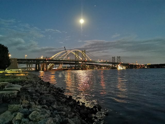
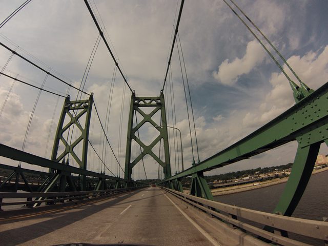
This is one of the most unique pair of bridges ever seen. So many different things make these bridges unique. First, these bridges visually appear to be absolutely identical. However, the northbound bridge was built in 1935, yet the southbound bridge was built decades later in 1960! Usually bridges built in 1960 have drastic differences between those built in 1935. Even the Grand Island Bridges, with a similar history and construction dates, have subtle differences in the design of the built-up beams. No such differences are apparent on the I-74 Bridges. It appears that the original plans for the 1935 bridge were simply taken out and used without any noteworthy changes to construct the 1960 bridge.
Simply having two identical suspension bridges side by side is a unique feature. As such, an interesting place to view the bridges is in between the anchorages of the two bridges. This is a view that cannot be found anywhere else.
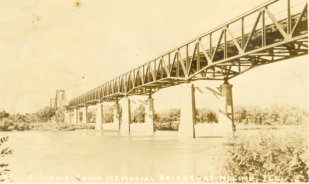
The other unique feature of these bridges is the southern pony truss approach spans. From the road, these spans look similar to the stiffening truss. From below, these trusses have a haunched design at the piers. The trusses are continuous, adding to their technological significance. In between the pony truss spans and the suspension spans, there are deck truss spans. Additional deck trusses at this location in between the two bridges form a large plaza area on the bridge which is currently used for maintenance vehicles and utilities. There are also deck truss spans north of the suspension spans.

The bridges include cable bents where the orientation of the cable changes near deck level and is directed straight into the anchorages.

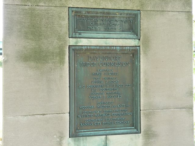
The 1935 bridge was built by the prestigious firm that was begun by famous bridge engineer Ralph Modjeski. At the time the 1935 bridge was built, the company had the name of Modjeski, Masters, and Case. Later and to this day the company is known became known as Modjeski and Masters. Perhaps unsurprisingly, Modjeski and Masters was the company hired as the consulting engineer for the construction of the 1960 bridge. The contractors for the 1935 bridge included McClintic Marshall Company for the superstructure and Kansas City Bridge Company for the substructure. The contractors for the 1960 bridge included the Bethlehem Steel Corporation for the superstructure, the Dravo Corporation for the substructure, and the Valley Construction Company for the approaches.
The bridges display classic details that are shared with many suspension bridges associated with Ralph Modjeski. These include towers with large "X" patterns except at the top where horizontal beams interrupt the pattern. The use of pony truss stiffening is also common among his bridges.
The bridges are very aesthetically pleasing, from the tower design, to the graceful lines of the suspension system. The pony truss stiffening introduces a geometric complexity to the bridge, further enhancing the aesthetics of the bridge.
Both bridges should be considered historically and technologically significant examples of suspension and truss bridges that were also built by a noteworthy engineering firm. The 1935 Bridge is further significant for association with Depression-era relief funds. The plaque for the bridge
The plaques for the bridge are currently located on a monument in the northeast quadrant around the bridges in a small park. This is not the original location of the 1935 plaques and monument, and the 1960 plaques have been added to the monument. This monument may move again when the historic bridges are replaced.
These bridges, despite their historic and aesthetic significance were replaced. The main reason for replacement is that the lanes on these bridges are narrow, and there are no shoulders, undesirable for an Interstate highway. Additionally, there is a desire to add a third lane for the roadway. HistoricBridges.org does not dispute the need for additional space and capacity on the Interstate. However, it is highly disturbing that this project includes the demolition of both of these beautiful historic bridges. At the very least, one of the two bridges should have been left standing next to the new bridges for pedestrian use. This solution would provide for the needs of the freeway, while also preserving one of the beautiful historic bridges. Even this solution would be a major compromise since it would destroy the unique visuals associated with a pair of suspension bridges, however, it would be a fair compromise that would address the concerns for capacity on the freeway and the need to preserve our nation's transportation heritage. However, compromise was apparently been thrown out the window with this project. Even through these bridges were in structurally good condition (they were being replaced due to their narrow roadways) there was a refusal to leave one bridge standing for pedestrian use, even though it would likely be able to serve such light traffic for decades even with minimal maintenance. It is disappointing to see this lack of concern for these beautiful bridges that were built to honor the veterans of the World Wars.
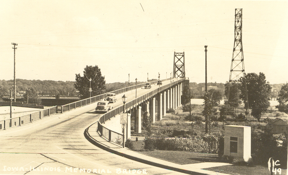
Information and Findings From Iowa's Historic Bridge InventoryDiscussion of Bridge One of the myriad bridges crossing the muddy Mississippi River, the Iowa-Illinois Memorial Bridge, dedicated to area soldiers of World War 1, connects the two cities of Bettendorf, Iowa and Moline, Illinois. Local citizens had long fostered the idea of a permanent bridge at this location, owing to the overcrowded conditions at the federally-owned Davenport Rock Island Bridge, spanning the river at Davenport three miles downstream. Traffic studies indicated that building a toll structure between Moline and Bettendorf would effectively pay for itself in a reasonable amount of time. Armed with this information, the two counties persuaded the Public Works Administration (PWA) to finance the project. Labor used to construct the bridge was employed through the National Re-Employment Service at Davenport and Rock Island. The PWA, after advertising for competitive bids, let out a series of contracts for the bridge's construction. Modjeski and Masters, a Pennsylvania-based engineering firm, was awarded the contract to design the
structure, and final plans and specifications were approved early in 1934. The engineers had drawn up a bridge divided into two parts by a narrow island. North of the island the bridge consists of a three-span twisted-wire-strand
cable suspension bridge. South of the island are six deck truss approach spans, supported on seven piers. The official bridge-opening was a gala event with governors of both states and thousands of people in attendance. Since its construction, the Memorial Bridge continues to carry regional vehicular traffic in unaltered condition. The traffic flow, however, has increased dramatically since the 1930s, and in 1970 an identical span, parallel to the original Memorial Bridge, was erected. This newer span not only preserves the original truss in place, but alleviates traffic congestion on the older bridge. The Memorial Bridge is significant due to its high degree of structural and historical integrity, and the creative manner in which the problem of growth was resolved [adapted from Crow-Dolby 1992]. Bridge Considered Historic By Survey: Yes |
![]()
![]()
![]()
![]()
![]()
![]()
![]()

![]()
![]()
This historic bridge has been demolished. This map is shown for reference purposes only.
Coordinates (Latitude, Longitude):
Search For Additional Bridge Listings:
Bridgehunter.com: View listed bridges within 0.5 miles (0.8 kilometers) of this bridge.
Bridgehunter.com: View listed bridges within 10 miles (16 kilometers) of this bridge.
Additional Maps:
Google Streetview (If Available)
GeoHack (Additional Links and Coordinates)
Apple Maps (Via DuckDuckGo Search)
Apple Maps (Apple devices only)
Android: Open Location In Your Map or GPS App
Flickr Gallery (Find Nearby Photos)
Wikimedia Commons (Find Nearby Photos)
Directions Via Sygic For Android
Directions Via Sygic For iOS and Android Dolphin Browser
USGS National Map (United States Only)
Historical USGS Topo Maps (United States Only)
Historic Aerials (United States Only)
CalTopo Maps (United States Only)

© Copyright 2003-2026, HistoricBridges.org. All Rights Reserved. Disclaimer: HistoricBridges.org is a volunteer group of private citizens. HistoricBridges.org is NOT a government agency, does not represent or work with any governmental agencies, nor is it in any way associated with any government agency or any non-profit organization. While we strive for accuracy in our factual content, HistoricBridges.org offers no guarantee of accuracy. Information is provided "as is" without warranty of any kind, either expressed or implied. Information could include technical inaccuracies or errors of omission. Opinions and commentary are the opinions of the respective HistoricBridges.org member who made them and do not necessarily represent the views of anyone else, including any outside photographers whose images may appear on the page in which the commentary appears. HistoricBridges.org does not bear any responsibility for any consequences resulting from the use of this or any other HistoricBridges.org information. Owners and users of bridges have the responsibility of correctly following all applicable laws, rules, and regulations, regardless of any HistoricBridges.org information.
![]()