We Recommend:
Bach Steel - Experts at historic truss bridge restoration.
BridgeHunter.com Phase 1 is released to the public! - Visit Now
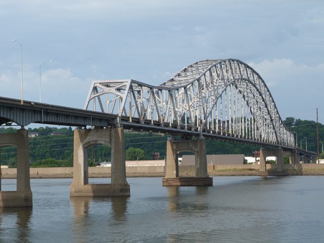
Julien Dubuque Bridge
Primary Photographer(s): Nathan Holth
Bridge Documented: October 21, 2013
US-20 and IL-35 (Dodge Street) Over Mississippi River, Railroad, and Various Streets
Dubuque and East Dubuque: Dubuque County, Iowa and Jo Daviess County, Illinois: United States
Metal Continuous (Arch and Suspended Deck) Tied Braced Ribbed Through Arch, Fixed and Approach Spans: Metal Cantilever Deck Girder, Fixed
1943 By Builder/Contractor: Bethlehem Steel Company of Bethlehem, Pennsylvania and Engineer/Design: Howard, Needles, Tammen and Bergendorff of Kansas City, Missouri
1992
845.0 Feet (257.6 Meters)
5,760.0 Feet (1755.6 Meters)
28 Feet (8.53 Meters)
3 Main Span(s) and 13 Approach Span(s)
23880

View Information About HSR Ratings
Bridge Documentation
Additional Information: Although it takes place in Louisiana in a city modeled after New Orleans, the game Mafia III features a bridge that was inspired strongly by this bridge to the point where the distinctive portal bracing is replicated in a high level of detail in-game. It is the bridge connecting "Downtown" to "Barklay Mills" in the game.
View Archived National Bridge Inventory Report - Has Additional Details and Evaluation
View Historical Articles About This Bridge
View The National Register of Historic Places Nomination Form For This Historic Bridge
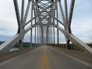
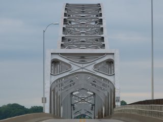 Be sure to view the National Register of Historic Places Nomination Form for this bridge
as it contains a fairly detailed discussion of this bridge. This is a unique iconic landmark bridge of unusual design. It looks like the type of bridge normally described as a continuous truss with a suspended deck. However, the bridge is
described as a "continuous tied arch." The bridge was noted as the second example of this bridge type ever built and the longest of this type in the world at the time.
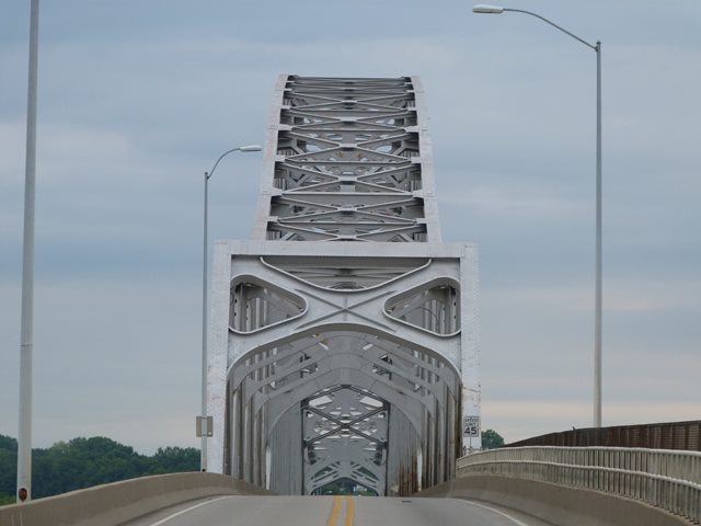
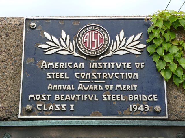
The bridge won an award of "Most Beautiful Steel Bridge" from the American Institute of Steel Construction. In researching historic bridges, the award is a good indicator of a bridge that captured the aesthetic ideals of the period in which is what built. The arch-shaped design of the overall bridge is indeed aesthetically pleasing. Other elements have a visually impressive appearance as well, particularly the unique portal bracing with is a massive "X" that gives the bridge's main spans a dramatic start and finish for anyone crossing the bridge. These main spans rise impressively above the roadway, adding to the dramatic experience of crossing the bridge. Cutting edge for the time, this bridge does not have any v-lacing or lattice in its built-up members. Instead, some of the built-up members on the bridge feature oval hand-holes, a detail common in large steel members on mid 20th Century bridges.
The approach spans, which are deck plate girder spans, are of note too on this bridge. The approach spans closest to the main spans feature an attractive haunched design, while the spans toward the ends of the bridge are not haunched. The deck plate girder spans are also noted for this use of a cantilevered design with suspended spans present, resting on the cantilevered portions of the girders.
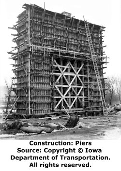
Above: These photos show the formwork used for pouring the concrete piers.
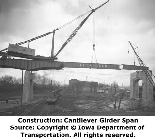
Above: These photos show erection of the cantilevered girder approach spans.
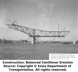
Above: The erection of the main spans of the bridge are shown. The most impressive aspects of this construction was the use of balanced cantilever construction where the bridge trusses were built outward from the pier with only a single steel bent next to the pier added for temporary support.
Above: This photo shows the construction of the main span just before closure of the trussed portion of the bridge in the middle of the river.
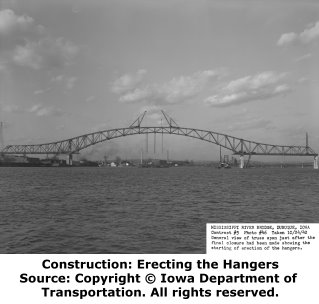
Above: The construction of the trussed portion has been completed in this photo and the hangers are now being installed.
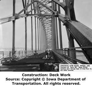
Above: This photo shows the bridge with the floor beams in place, but the deck not yet constructed.
Information and Findings From Iowa's Historic Bridge InventoryDiscussion of Bridge Named one of the top ten bridges in the country by Road and Bridges Magazine in 2003, the Julien Dubuque bridge spanning the Mississippi River was built by Ned Ashton of Bethlehem Steel in 1943. The current span is the only the latest historic bridge connecting the city of Dubuque with the Illinois side of the Mississippi. From the start, Dubuque's fortunes have been tied inexorably to the Mississippi River. Founded by lead miners in 1833, the settlement soon became a stopping point for boats that plied the river trade. But Dubuque almost immediately concerned itself with travel across the river as well. One of the first commercial businesses established in the fledgling town was a ferry operation on the river, founded by General George W. Jones. The wagon ferries contributed greatly to the commercial prosperity of Dubuque and influenced the town's physical development through the location of their terminals. But the city paid a premium for its single railroad ferry. "The interests of Dubuque and Northern Iowa suffered for many years in consequence of the lack of transportation facilities between Dunleith and Dubuque," a historian wrote in 1880. "The ferry which plied between these cities was in the hands of the Illinois Central Railroad Company, and it was charged that this medium of communication was not only a merciless monopoly, but inadequate to the purpose." After years of promoting for a railroad bridge by various Dubuque citizen's groups, the Dubuque and Dunleith Bridge Company was formed in 1866. The company received a Congressional charter for the bridge that year--one of the first such bridge charters granted for the Mississippi River. In January 1869, the company contracted with the Keystone Bridge Company of Philadelphia to build the original railroad bridge. Work on the first abutment began on January 27th; on December 15th the bridge was completed. The railroad bridge was renovated in 1900 and remains in operation today. The Dubuque Wagon Bridge opened in 1887 and was torn down in 1944 after the Julien Dubuque Bridge was completed in 1943. Two parts of the Wagon bridge were saved and used to build two county bridges, the White Water Creek Bridge, and the Cloie Bridge. Julien Dubuque himself was an early Iowa pioneer, settling in what was then Spanish Louisiana in 1785. A fur-trader and lead-miner, Dubuque remained twenty years in northeastern Iowa, employing indigenous people and French Canadian settlers alike. He was buried on the top of a bluff overlooking the Mississippi River near Dubuque [adapted from Fraser 1993]. Additional Discussion of Bridge The Julien Dubuque Bridge is a continuous steel-arch truss bridge with a suspended deck that traverses the Mississippi River. It joins the cities of Dubuque, Iowa, and East Dubuque, Illinois. Bridge Considered Historic By Survey: Yes |
![]()
Photo Galleries and Videos: Julien Dubuque Bridge
Structure Overview
Original / Full Size PhotosA collection of overview photos that show the bridge as a whole and general areas of the bridge. This gallery offers photos in the highest available resolution and file size in a touch-friendly popup viewer.
Alternatively, Browse Without Using Viewer
![]()
Structure Details
Original / Full Size PhotosA collection of detail photos that document the parts, construction, and condition of the bridge. This gallery offers photos in the highest available resolution and file size in a touch-friendly popup viewer.
Alternatively, Browse Without Using Viewer
![]()
Structure Overview
Mobile Optimized PhotosA collection of overview photos that show the bridge as a whole and general areas of the bridge. This gallery features data-friendly, fast-loading photos in a touch-friendly popup viewer.
Alternatively, Browse Without Using Viewer
![]()
Structure Details
Mobile Optimized PhotosA collection of detail photos that document the parts, construction, and condition of the bridge. This gallery features data-friendly, fast-loading photos in a touch-friendly popup viewer.
Alternatively, Browse Without Using Viewer
![]()
CarCam: Westbound Crossing
Full Motion VideoNote: The downloadable high quality version of this video (available on the video page) is well worth the download since it offers excellent 1080 HD detail and is vastly more impressive than the compressed streaming video. Streaming video of the bridge. Also includes a higher quality downloadable video for greater clarity or offline viewing.
![]()
CarCam: Eastbound Crossing
Full Motion VideoNote: The downloadable high quality version of this video (available on the video page) is well worth the download since it offers excellent 1080 HD detail and is vastly more impressive than the compressed streaming video. Streaming video of the bridge. Also includes a higher quality downloadable video for greater clarity or offline viewing.
![]()
Maps and Links: Julien Dubuque Bridge
Coordinates (Latitude, Longitude):
Search For Additional Bridge Listings:
Bridgehunter.com: View listed bridges within 0.5 miles (0.8 kilometers) of this bridge.
Bridgehunter.com: View listed bridges within 10 miles (16 kilometers) of this bridge.
Additional Maps:
Google Streetview (If Available)
GeoHack (Additional Links and Coordinates)
Apple Maps (Via DuckDuckGo Search)
Apple Maps (Apple devices only)
Android: Open Location In Your Map or GPS App
Flickr Gallery (Find Nearby Photos)
Wikimedia Commons (Find Nearby Photos)
Directions Via Sygic For Android
Directions Via Sygic For iOS and Android Dolphin Browser
USGS National Map (United States Only)
Historical USGS Topo Maps (United States Only)
Historic Aerials (United States Only)
CalTopo Maps (United States Only)

