We Recommend:
Bach Steel - Experts at historic truss bridge restoration.
Jefferson Street Viaduct

Primary Photographer(s): Nathan Holth and Rick McOmber
Bridge Documented: July 2, 2009
Ottumwa: Wapello County, Iowa: United States
Metal Continuous 12 Panel Rivet-Connected Warren Deck Truss, Fixed and Approach Spans: Metal Deck Girder, Fixed
1936 By Builder/Contractor: Wisconsin Bridge and Iron Company of Milwaukee, Wisconsin
1984
150.0 Feet (45.7 Meters)
2,120.5 Feet (646.3 Meters)
33.1 Feet (10.09 Meters)
9 Main Span(s) and 8 Approach Span(s)
9386

View Information About HSR Ratings
Bridge Documentation
View Archived National Bridge Inventory Report - Has Additional Details and Evaluation
View Historic American Engineering Record (HAER) Documentation For This Bridge
HAER Data Pages, PDF
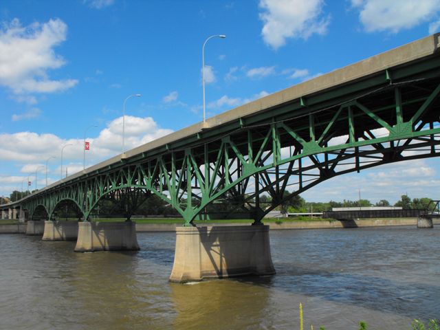
This bridge is an impressive and rare multi-span continuous deck truss. Continuous deck truss bridges configured with multiple, relatively short spans are relatively rare. They tended to be used with much longer individual spans to cross deep river valleys. As such, this bridge is significant as a rare expression of this bridge design. The design is also highly attractive, and the bridge contributes greatly to the aesthetic qualities of Ottumwa's riverfront. The bridge retains good historic integrity, although the deck has been replaced which includes the loss of the original railings and replacement with unappealing New Jersey barriers. Future preservation work should include the replacement of these barriers with AASHTO approved and crash-tested aesthetic alternatives.
There is a series of deck plate girder spans at each end, with more present at the northern end. The main spans of the bridge consist of four riveted Warren deck trusses at the southernmost end of the main span system, while the north end of the main span system is five continuous Warren deck truss spans.
HAER has a significant historical narrative describing the planning, design, and construction of this bridge. Links are available further up on this page.
Information and Findings From Iowa's Historic Bridge InventoryDiscussion of Bridge Although it was built in 1935-36, the Jefferson Street Viaduct traces its roots 15 years earlier. Beginning in 1921 Ottumwa city officials began meeting with the CB&Q, the CRI&P and the CM&StP railroads with the idea of building a viaduct over the numerous tracks that paralleled the Des Moines River. Nothing concrete came of these discussions, however, and after a change of city administration, the project was shelved until 1929. Planning began again that year, with the city considering sites at several streets. Because the proposed bridge was to carry U.S. Highways 34 and 63, the city sought financial and design help from the Iowa State Highway Commission. ISHC agreed to fund construction of a new bridge over the Des Moines River, provided the city would pay for construction of the viaduct on the northern end. Between 1930 and 1935 ISHC presided over meetings with the city and the railroads in an effort to resolve differences among the three entities. Finally, highway commission engineers drew up a five-span, riveted Warren deck truss, cantilevered from massive concrete piers in the river. The highway commission designated the viaduct's construction Project P-480 and in December 1934 awarded a contract for it to the Wisconsin Bridge and Iron Company. The Milwaukee-based firm began excavations for the substructure early in 1935 and the bridge was completed in May 1936. At the dedication ceremonies on May 28th, Iowa Governor Clyde Herring and Ottumwa Mayor Edwin Manning spoke before a crowd of about 15,000 people, before two Ottumwa girls christened the bridge with bottles of champagne. The Jefferson Street Viaduct has carried heavy traffic since, with a major rehabilitation in 1983 as its most substantial alteration. Fueled with federal funds from the various relief agencies, the Iowa State Highway Commission designed several large-scale urban viaducts in the 1930s. These featured a variety of superstructure types, but perhaps none was as distinctive as the Jefferson Street Viaduct in Ottumwa. The city had wanted a concrete bridge here, in part because of the aesthetics of the concrete arch form. But ISHC opted instead for this steel truss design as a more economical alternative. With its five arched deck truss spans held above the Des Moines River on tapered concrete pedestals, the structure is one of Iowa's most handsomely proportioned highway trusses. It is technologically noteworthy as an uncommon application of deck truss technology in Iowa, a state not known for generous underdeck clearances at its stream and river crossings. With its structural integrity largely intact, the Jefferson Street Viaduct was an important exercise in Iowa urban bridge construction in the 1930s [adapted from Fraser 1993]. Bridge Considered Historic By Survey: Yes |
![]()
Photo Galleries and Videos: Jefferson Street Viaduct
Bridge Photo-Documentation
Original / Full Size PhotosA collection of overview and detail photos. This gallery offers photos in the highest available resolution and file size in a touch-friendly popup viewer.
Alternatively, Browse Without Using Viewer
![]()
Bridge Photo-Documentation
Mobile Optimized PhotosA collection of overview and detail photos. This gallery features data-friendly, fast-loading photos in a touch-friendly popup viewer.
Alternatively, Browse Without Using Viewer
![]()
Maps and Links: Jefferson Street Viaduct
Coordinates (Latitude, Longitude):
Search For Additional Bridge Listings:
Bridgehunter.com: View listed bridges within 0.5 miles (0.8 kilometers) of this bridge.
Bridgehunter.com: View listed bridges within 10 miles (16 kilometers) of this bridge.
Additional Maps:
Google Streetview (If Available)
GeoHack (Additional Links and Coordinates)
Apple Maps (Via DuckDuckGo Search)
Apple Maps (Apple devices only)
Android: Open Location In Your Map or GPS App
Flickr Gallery (Find Nearby Photos)
Wikimedia Commons (Find Nearby Photos)
Directions Via Sygic For Android
Directions Via Sygic For iOS and Android Dolphin Browser
USGS National Map (United States Only)
Historical USGS Topo Maps (United States Only)
Historic Aerials (United States Only)
CalTopo Maps (United States Only)

