We Recommend:
Bach Steel - Experts at historic truss bridge restoration.
Vine Street Bridge
Iowa Bridge Number 12570

Primary Photographer(s): Nathan Holth
Bridge Documented: October 16, 2021
West Union: Fayette County, Iowa: United States
1910 By Builder/Contractor: N.M. Stark and Company of Des Moines, Iowa and Engineer/Design: Daniel Luten
Not Available or Not Applicable
66.0 Feet (20.1 Meters)
66.0 Feet (20.1 Meters)
40 Feet (12.19 Meters)
1 Main Span(s)
12570

View Information About HSR Ratings
Bridge Documentation
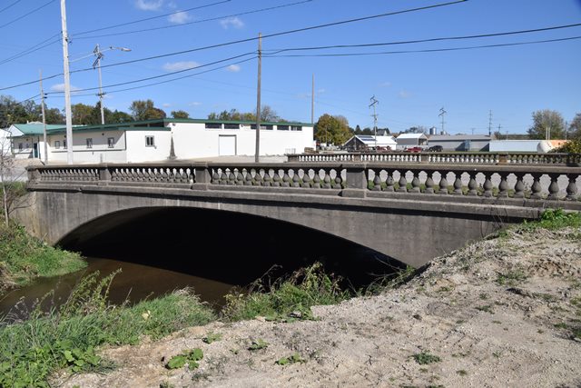
This is a very old and unaltered example of an urban style Luten arch bridge with the balustrade railings used for urban applications of the Luten patented arch design. N.M. Stark and Company of Des Moines, Iowa was one of many companies across the country authorized to build the patented Luten arch bridges.
View Archived National Bridge Inventory Report - Has Additional Details and Evaluation
View National Register of Historic Places Nomination Form For This Bridge
Information and Findings From Iowa's Historic Bridge InventoryDiscussion of Bridge In 1910 the Fayette County Board of Supervisors
received an urgent citizens' petition, asking for a permanent bridge to
carry Vine Street in West Union over Otter Creek. The petitioners
requested a 66-foot-wide structured to match the adjacent street width,
and they concluded by saying, "This is a dangerous place, being located
between two lines of Railroad track close together." In late winter of
1910 the supervisors solicited competitive bids to build the Vine Street
Bridge. A contract was awarded that March to N.M. Stark and Company of
Des Moines for $8,475. The award to Stark was hardly surprising. From
about the turn of the century until 1913, Stark built virtually all of
the county's concrete and steel bridges, holding a virtual monopoly on
Fayette County bridge construction and even providing the designs for
most of the structures. The design that Stark used for the concrete
arches was the patented elliptical arch of Indianapolis engineer Daniel
Luten. Stark was a licensee for Luten, building Luten arches under a
patent royalty agreement. The Vine Street Bridge was built by Stark that
year. Since its completion, the structure has carried vehicular traffic,
in unaltered condition. Bridge Considered Historic By Survey: Yes |
This bridge is tagged with the following special condition(s): Luten
![]()
Photo Galleries and Videos: Vine Street Bridge
Bridge Photo-Documentation
Original / Full Size PhotosA collection of overview and detail photos. This gallery offers photos in the highest available resolution and file size in a touch-friendly popup viewer.
Alternatively, Browse Without Using Viewer
![]()
Bridge Photo-Documentation
Mobile Optimized PhotosA collection of overview and detail photos. This gallery features data-friendly, fast-loading photos in a touch-friendly popup viewer.
Alternatively, Browse Without Using Viewer
![]()
Maps and Links: Vine Street Bridge
Coordinates (Latitude, Longitude):
Search For Additional Bridge Listings:
Bridgehunter.com: View listed bridges within 0.5 miles (0.8 kilometers) of this bridge.
Bridgehunter.com: View listed bridges within 10 miles (16 kilometers) of this bridge.
Additional Maps:
Google Streetview (If Available)
GeoHack (Additional Links and Coordinates)
Apple Maps (Via DuckDuckGo Search)
Apple Maps (Apple devices only)
Android: Open Location In Your Map or GPS App
Flickr Gallery (Find Nearby Photos)
Wikimedia Commons (Find Nearby Photos)
Directions Via Sygic For Android
Directions Via Sygic For iOS and Android Dolphin Browser
USGS National Map (United States Only)
Historical USGS Topo Maps (United States Only)
Historic Aerials (United States Only)
CalTopo Maps (United States Only)

