HistoricBridges.org Menu: HistoricBridges.org Menu:


We Recommend:
Bach Steel - Experts at historic truss bridge restoration.

HistoricBridges.org: Bridge Browser

Washington Avenue Bridge

Iowa Bridge Number 27000
Washington Avenue Bridge

Primary Photographer(s): Nathan Holth and Rick McOmber

Bridge Documented: July 1, 2009

View Photos
and Videos
View Maps
and Links

Facility Carried / Feature Intersected
Washington Avenue (Old US-20) Over Iowa River
Location
Iowa Falls: Hardin County, Iowa: United States
Structure Type
Concrete Open Spandrel Deck Arch, Fixed and Approach Spans: Concrete Deck Girder, Fixed
Construction Date and Builder / Engineer
1934 By Builder/Contractor: Welden Brothers Construction Company of Iowa Falls, Iowa
Rehabilitation Date
Not Available or Not Applicable
Main Span Length
173.0 Feet (52.7 Meters)
Structure Length
380.0 Feet (115.8 Meters)
Roadway Width
24 Feet (7.32 Meters)
Spans
2 Main Span(s) and 1 Approach Span(s)
Inventory Number
27000

Historic Significance Rating (HSR)
View Information About HSR Ratings

Bridge Documentation

View Archived National Bridge Inventory Report - Has Additional Details and Evaluation

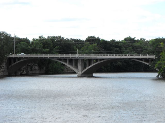
Iowa Falls is a city that is known for its historic concrete arch bridges, with three open spandrel arch bridges in town all listed on the National Register of Historic Places, and indeed have been included as part of a historic tour. This is a historic bridge that fits in beautifully with its natural and man-made surroundings, including the scenic rocky Iowa River and the other historic arch bridges in town. Aside from the replacement of a deck and railings, this two-span bridge retains good historic integrity. This is the only one of the three arch bridges in the city that has two spans instead of just one. Up until 1995, this bridge carried an alignment of US-20. The relocation of US-20 to a freeway south of town undoubtedly was beneficial for the longevity of this bridge.

Information and Findings From Iowa's Historic Bridge Inventory

Discussion of Bridge

This impressive two-span, open spandrel concrete arch crosses the Iowa River in Iowa Falls. Carrying U.S. Highway 20 (Washington Avenue) through the center of the city, the bridge dates to 1934. This structure was preceded by a steel bridge, known locally as the Foster Bridge, whose construction history is well-documented in county records. In late May of 1911 county commissioners adopted plans and specifications for the proposed bridge and immediately advertised for construction bids. Fifteen bids, ranging from $8,450 to $11,400, were received by June. Low-bidder Lana Construction Company of Harlan, Iowa, was awarded the contract, and the company began work soon after. Evidently the Foster Bridge experienced severe problems in the next few decades, and these structural difficulties precipitated construction of a new, permanent bridge in 1933. That year the state highway commission designed this two-span concrete arch structure and hired the Weldon Brothers Construction Company of Iowa Falls to build it. Costing $51,710.55, the Washington Avenue Bridge was ceremoniously opened on July 24, 1934, by Mrs. F.H. Cottrell, wife of the Iowa Falls mayor, with several thousand people in attendance. "I christen thee the Washington Avenue Bridge," she intoned, "a beautiful bridge over a beautiful river." Since its completion, the spandrel arch has functioned in place, carrying heavy urban and highway traffic, with only maintenance-related repairs.

Although highway commission engineers typically used riveted steel trusses for medium-span river crossings in rural settings, they used concrete open spandrel arches for a number of urban and small town structures in the 1920s. The Mederville Bridge, built in 1918, was apparently the first of these, designed as an alternate to a steel truss bridge. This was followed by the Adair Viaduct in 1923 and the Iowa Falls Bridge in 1928. By using open spandrel arches, ISHC could achieve a relatively long span at a reasonable cost, while contributing aesthetically to the urban settings in which the bridges stood. But given the restrictive parameters of the arches' use--urban setting, long-span crossing, sufficient vertical clearance--only a few were built during this period. The Washington Avenue Bridge is distinguished as a well-preserved, two-span example of this application of urban bridge design. A centerpiece for this small city, it is a local landmark and an important transportation-related resource [adapted from Crow-Dolby and Fraser 1992].

Bridge Considered Historic By Survey: Yes

Divider

Photo Galleries and Videos: Washington Avenue Bridge


View Photo Gallery

Bridge Photo-Documentation

Original / Full Size Photos
A collection of overview and detail photos. This gallery offers photos in the highest available resolution and file size in a touch-friendly popup viewer.
Alternatively, Browse Without Using Viewer

Divider

View Photo Gallery

Bridge Photo-Documentation

Mobile Optimized Photos
A collection of overview and detail photos. This gallery features data-friendly, fast-loading photos in a touch-friendly popup viewer.
Alternatively, Browse Without Using Viewer

Divider

Maps and Links: Washington Avenue Bridge

Coordinates (Latitude, Longitude):

Search For Additional Bridge Listings:

Bridgehunter.com: View listed bridges within 0.5 miles (0.8 kilometers) of this bridge.

Bridgehunter.com: View listed bridges within 10 miles (16 kilometers) of this bridge.

HistoricBridges.org Bridge Browser: View listed bridges within 0.5 miles (0.8 kilometers) of this bridge.

HistoricBridges.org Bridge Browser: View listed bridges within 10 miles (16 kilometers) of this bridge.

2021 National Bridge Inventory: View listed bridges within 0.5 miles (0.8 kilometers) of this bridge.

Additional Maps:

Google Maps

Google Streetview (If Available)

Bing Maps

OpenStreetMap

GeoHack (Additional Links and Coordinates)

Apple Maps (Via DuckDuckGo Search)

Apple Maps (Apple devices only)

MapQuest

HERE We Go Maps

ACME Mapper

Waze Map

Android: Open Location In Your Map or GPS App

Flickr Gallery (Find Nearby Photos)

Wikimedia Commons (Find Nearby Photos)

Directions Via Sygic For Android

Directions Via Sygic For iOS and Android Dolphin Browser

USGS National Map (United States Only)

Historical USGS Topo Maps (United States Only)

Historic Aerials (United States Only)

CalTopo Maps (United States Only)


Divider
 
Home Top

Divider

About - Contact

© Copyright 2003-2024, HistoricBridges.org. All Rights Reserved. Disclaimer: HistoricBridges.org is a volunteer group of private citizens. HistoricBridges.org is NOT a government agency, does not represent or work with any governmental agencies, nor is it in any way associated with any government agency or any non-profit organization. While we strive for accuracy in our factual content, HistoricBridges.org offers no guarantee of accuracy. Information is provided "as is" without warranty of any kind, either expressed or implied. Information could include technical inaccuracies or errors of omission. Opinions and commentary are the opinions of the respective HistoricBridges.org member who made them and do not necessarily represent the views of anyone else, including any outside photographers whose images may appear on the page in which the commentary appears. HistoricBridges.org does not bear any responsibility for any consequences resulting from the use of this or any other HistoricBridges.org information. Owners and users of bridges have the responsibility of correctly following all applicable laws, rules, and regulations, regardless of any HistoricBridges.org information.

Admin Login

Divider