

View Information About HSR Ratings
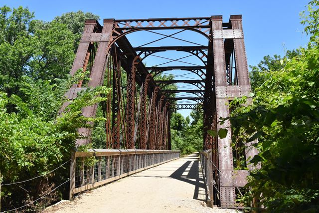
2018 Update: John Marvig located ATSF Bridge Records which answered some questions about this bridge. The bridge was built in Built 1890, the approach span was addded in 1900, and it was strengthened in 1919 using pieces from Bridge #533A over the Purgatoire River near Las Animas, Colorado. That span was built in 1898.
This railroad bridge is a very unusual design. It is composed of four truss lines, with each pair sitting right next to each other and connected by riveted plates. At quick glance, its configuration appears to be an original detail much like this bridge in Canada. However, closer inspection reveals that with this example in Kansas, the detail is not original and is the result of an alteration. Because rivets are used to connect the two truss pairs it is assumed that the alteration occurred long ago, at least before ca. 1970 to be sure. It appears likely that what happened is a two-span through truss in some unknown location was relocated here, and the two truss spans were combined into a single, stronger single-span through truss span at this location. Evidence for this includes the empty rivet holes on the outer trusses at the top of the vertical members where knee braces would have originally been attached. Splices at the center of the struts and portal bracing suggest that the width of the roadway was also changed at this time. The plates used to connect the truss pairs appear to be salvaged because numerous empty rivet holes are present on them.
![]()
![]()
![]()
Coordinates (Latitude, Longitude):
Search For Additional Bridge Listings:
Bridgehunter.com: View listed bridges within 0.5 miles (0.8 kilometers) of this bridge.
Bridgehunter.com: View listed bridges within 10 miles (16 kilometers) of this bridge.
Additional Maps:
Google Streetview (If Available)
GeoHack (Additional Links and Coordinates)
Apple Maps (Via DuckDuckGo Search)
Apple Maps (Apple devices only)
Android: Open Location In Your Map or GPS App
Flickr Gallery (Find Nearby Photos)
Wikimedia Commons (Find Nearby Photos)
Directions Via Sygic For Android
Directions Via Sygic For iOS and Android Dolphin Browser
USGS National Map (United States Only)
Historical USGS Topo Maps (United States Only)
Historic Aerials (United States Only)
CalTopo Maps (United States Only)

© Copyright 2003-2024, HistoricBridges.org. All Rights Reserved. Disclaimer: HistoricBridges.org is a volunteer group of private citizens. HistoricBridges.org is NOT a government agency, does not represent or work with any governmental agencies, nor is it in any way associated with any government agency or any non-profit organization. While we strive for accuracy in our factual content, HistoricBridges.org offers no guarantee of accuracy. Information is provided "as is" without warranty of any kind, either expressed or implied. Information could include technical inaccuracies or errors of omission. Opinions and commentary are the opinions of the respective HistoricBridges.org member who made them and do not necessarily represent the views of anyone else, including any outside photographers whose images may appear on the page in which the commentary appears. HistoricBridges.org does not bear any responsibility for any consequences resulting from the use of this or any other HistoricBridges.org information. Owners and users of bridges have the responsibility of correctly following all applicable laws, rules, and regulations, regardless of any HistoricBridges.org information.
![]()