We Recommend:
Bach Steel - Experts at historic truss bridge restoration.
BridgeHunter.com Phase 1 is released to the public! - Visit Now
Young's High Bridge
Tyrone Railroad Bridge

Primary Photographer(s): Nathan Holth
Bridge Documented: July 7, 2013 and November 29, 2017
Tyrone: Anderson County, Kentucky and Woodford County, Kentucky: United States
Metal Cantilever 20 Panel Pin-Connected Deck Truss, Fixed and Approach Spans: Metal Deck Girder, Fixed
1889 By Builder/Contractor: Union Bridge Company of Athens, Pennsylvania and Buffalo, New York and Detroit Bridge and Iron Works of Detroit, Michigan and Engineer/Design: John W. MacLeod
Not Available or Not Applicable
551.0 Feet (167.9 Meters)
1,650.0 Feet (502.9 Meters)
Not Available
3 Main Span(s)
Not Applicable

View Information About HSR Ratings
Bridge Documentation
View A Historical Article Discussing This Bridge
View The Bridge Owner's Website
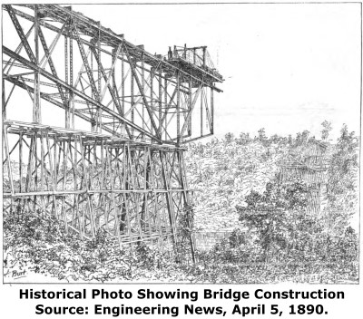
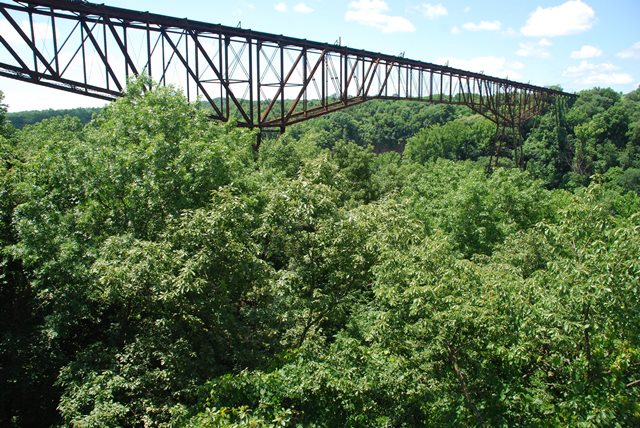
This is an extremely significant historic bridge. It was the largest cantilever span in the country when completed. The span between center of towers (bents) is 551 feet. It did not hold this record long however. The next record holder was the 660 foot Red Rock Cantilever Bridge carrying Atlantic and Pacific Railroad crossing of the Colorado River in Needles, California, built in 1889. This bridge however no longer exists. The Young's High Bridge is additionally significant as one of the oldest cantilever truss bridges in the United States. In fact, the only one known to be older than this one (and only by one year) is the Poughkeepsie Bridge which was built by the same bridge company and has several design similarities. The Kentucky River was home to an earlier cantilever truss bridge, the High Bridge, but it was replaced in 1911. In contrast, Young's High Bridge enjoys outstanding historic integrity. Given its significance as an unaltered record breaker, an example major engineering effort, and one of the oldest of its kind, this bridge has national significance. The extreme height of the bridge is listed as 258 feet. The total length of the cantilever structure including anchor arms is 998 feet.
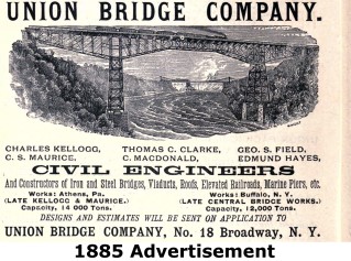
The bridge was designed and built by the Union Bridge Company however the Union Bridge Company only manufactured the eyebars for the bridge. All other elements were fabricated by the Detroit Bridge and Iron Works. Baird Brothers was the erection contractor. Hopkins and Company was the substructure contractor. The Chief Engineer for the project worked for the Louisville Southern Railway and was John MacLeod. .
The bridge last carried train traffic in 1985 and the bridge was subsequently abandoned. The bridge is currently owned by Vertigo Bungee which plans to offer base jumping from the bridge. Whatever use the bridge currently has, the important thing is that it remains standing and retains its historic integrity.
This bridge is next to a historic highway truss bridge.
![]()
Photo Galleries and Videos: Young's High Bridge
2017 Bridge Photo-Documentation
Original / Full Size PhotosA collection of overview and detail photos. This gallery offers photos in the highest available resolution and file size in a touch-friendly popup viewer.
Alternatively, Browse Without Using Viewer
![]()
2017 Bridge Photo-Documentation
Mobile Optimized PhotosA collection of overview and detail photos. This gallery features data-friendly, fast-loading photos in a touch-friendly popup viewer.
Alternatively, Browse Without Using Viewer
![]()
2013 Bridge Photo-Documentation
Original / Full Size PhotosA collection of overview and detail photos. This gallery offers photos in the highest available resolution and file size in a touch-friendly popup viewer.
Alternatively, Browse Without Using Viewer
![]()
2013 Bridge Photo-Documentation
Mobile Optimized PhotosA collection of overview and detail photos. This gallery features data-friendly, fast-loading photos in a touch-friendly popup viewer.
Alternatively, Browse Without Using Viewer
![]()
Maps and Links: Young's High Bridge
Coordinates (Latitude, Longitude):
Search For Additional Bridge Listings:
Bridgehunter.com: View listed bridges within 0.5 miles (0.8 kilometers) of this bridge.
Bridgehunter.com: View listed bridges within 10 miles (16 kilometers) of this bridge.
Additional Maps:
Google Streetview (If Available)
GeoHack (Additional Links and Coordinates)
Apple Maps (Via DuckDuckGo Search)
Apple Maps (Apple devices only)
Android: Open Location In Your Map or GPS App
Flickr Gallery (Find Nearby Photos)
Wikimedia Commons (Find Nearby Photos)
Directions Via Sygic For Android
Directions Via Sygic For iOS and Android Dolphin Browser
USGS National Map (United States Only)
Historical USGS Topo Maps (United States Only)
Historic Aerials (United States Only)
CalTopo Maps (United States Only)


