

View Information About HSR Ratings
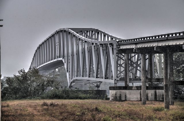
The substructure contractors for this bridge were Al Johnston Construction Company and the Massman Construction Company of Minneapolis (assumed to be the same as the company that was based in Kansas City). The superstructure contractor was J. H. Beasley Company of Dallas, Texas.
Constructed in 1973, and being composed of steel fabricated using modern, non-historic details, this bridge (and its even newer 1988 companion bridge) is included on HistoricBridges.org not so much for its historic significance but for how this site illustrates the evolution (or some might argue, devolution) of bridge design. To understand the changes in bridge design, compare these bridges to the 1971 Simmesport Bridge and the 1938 Blue Water Bridge. The Blue Water Bridge, built in 1938, represents an older and highly significant historic bridge, noted for its graceful arch truss design, and rich use of riveted built-up beams containing lattice bars giving the bridge a complex geometric beauty. As the years progressed, the use of v-lacing and lattice diminished, and this made truss bridges look more simple. Field connections began to be bolted, but rivets continued to be used for built-up beams fabricated in the shop. The Simmesport Bridge, completed in 1971 and probably built to a design that was drawn up in the late 1960s, still shows this use of rivets in the shop-fabricated built-up beams, and it still shows a pleasing arched shape to the arch-truss design. It marks the end of an era. Around 1970, the use of rivets dropped completely from bridges, replaced by the exclusive use of welds and bolts. This had a dramatic affect on the geometric complexity of a bridge. Without v-lacing and lattice, and on top of that without the aesthetically pleasing visual texture that rivets add to steel, truss bridges took on a much less visually pleasing appearance. The 1973 bridge at Krotz Springs shows the result of this, with its welded beams that are bolted together. From this point forward, truss bridges continued to devolve into less visually pleasing forms, through increasing simplicity in design with no attention paid to aesthetics whatsoever. The outcome of such changes is painfully obvious in the 1988 companion bridge that was built next to the 1973 bridge. As simple and plain as the 1973 bridge looks, the 1988 bridge is even more so. It still has the same engineering thought as earlier arch-truss bridges, with a deck truss span that transitions into a through truss span, but no attempt was made to create an aesthetically pleasing arch shape as in all the other examples discussed here. Thus, the 1988 bridge shows the complete devolution of the metal truss bridge from a beautiful bridge type to a downright ugly bridge type.
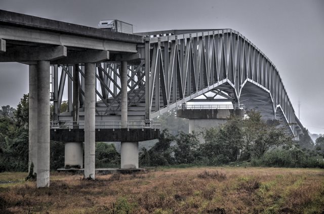
Above: The 1988 bridge.
It is also worth noting that the 1988 bridge replaced a historic K-truss bridge at this location. The K-truss served two-way traffic until it became part of a one-way couplet with the construction of the 1973 bridge. The above HAER links refer to this bridge. Also, photos from the Historic American Engineering Record of the historic K-truss bridge are shown below.


![]()
![]()
![]()
Coordinates (Latitude, Longitude):
Search For Additional Bridge Listings:
Bridgehunter.com: View listed bridges within 0.5 miles (0.8 kilometers) of this bridge.
Bridgehunter.com: View listed bridges within 10 miles (16 kilometers) of this bridge.
Additional Maps:
Google Streetview (If Available)
GeoHack (Additional Links and Coordinates)
Apple Maps (Via DuckDuckGo Search)
Apple Maps (Apple devices only)
Android: Open Location In Your Map or GPS App
Flickr Gallery (Find Nearby Photos)
Wikimedia Commons (Find Nearby Photos)
Directions Via Sygic For Android
Directions Via Sygic For iOS and Android Dolphin Browser
USGS National Map (United States Only)
Historical USGS Topo Maps (United States Only)
Historic Aerials (United States Only)
CalTopo Maps (United States Only)

© Copyright 2003-2026, HistoricBridges.org. All Rights Reserved. Disclaimer: HistoricBridges.org is a volunteer group of private citizens. HistoricBridges.org is NOT a government agency, does not represent or work with any governmental agencies, nor is it in any way associated with any government agency or any non-profit organization. While we strive for accuracy in our factual content, HistoricBridges.org offers no guarantee of accuracy. Information is provided "as is" without warranty of any kind, either expressed or implied. Information could include technical inaccuracies or errors of omission. Opinions and commentary are the opinions of the respective HistoricBridges.org member who made them and do not necessarily represent the views of anyone else, including any outside photographers whose images may appear on the page in which the commentary appears. HistoricBridges.org does not bear any responsibility for any consequences resulting from the use of this or any other HistoricBridges.org information. Owners and users of bridges have the responsibility of correctly following all applicable laws, rules, and regulations, regardless of any HistoricBridges.org information.
![]()