

View Information About HSR Ratings
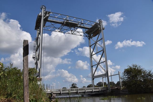
This bridge is one of a significant number of vertical lift bridges built in Louisiana from the 1930s through the 1960s. During this period, the general design of these bridges did not change significantly. They are noted for lightweight towers with bracing connecting the two towers (such bracing is uncommon in larger lift bridges elsewhere in the country), small counterweights, and very simple beam or girder lift spans of relatively short span length. The bridges were uniquely suited to the state's many small-scale navigable waterways and are a contrast to the more massive long-span lift bridges found on other major waterways in the United States. Small scale vertical lift bridges like these are not common in other states, so while they are "common" in Louisiana, they are nevertheless important to preserve as they document a bridge type that is uncommon in the rest of the country.
This bridge has been rehabilitated. Before rehabilitation, the bridge had an interesting spiral staircase that ran all the way to the top of the tower. This was replaced with a ladder.
If anyone has photos of this bridge in the raised position and is willing to share them with HistoricBridges.org (we will provide photo credit) please contact us.
![]()
![]()
![]()
Coordinates (Latitude, Longitude):
Search For Additional Bridge Listings:
Bridgehunter.com: View listed bridges within 0.5 miles (0.8 kilometers) of this bridge.
Bridgehunter.com: View listed bridges within 10 miles (16 kilometers) of this bridge.
Additional Maps:
Google Streetview (If Available)
GeoHack (Additional Links and Coordinates)
Apple Maps (Via DuckDuckGo Search)
Apple Maps (Apple devices only)
Android: Open Location In Your Map or GPS App
Flickr Gallery (Find Nearby Photos)
Wikimedia Commons (Find Nearby Photos)
Directions Via Sygic For Android
Directions Via Sygic For iOS and Android Dolphin Browser
USGS National Map (United States Only)
Historical USGS Topo Maps (United States Only)
Historic Aerials (United States Only)
CalTopo Maps (United States Only)

© Copyright 2003-2024, HistoricBridges.org. All Rights Reserved. Disclaimer: HistoricBridges.org is a volunteer group of private citizens. HistoricBridges.org is NOT a government agency, does not represent or work with any governmental agencies, nor is it in any way associated with any government agency or any non-profit organization. While we strive for accuracy in our factual content, HistoricBridges.org offers no guarantee of accuracy. Information is provided "as is" without warranty of any kind, either expressed or implied. Information could include technical inaccuracies or errors of omission. Opinions and commentary are the opinions of the respective HistoricBridges.org member who made them and do not necessarily represent the views of anyone else, including any outside photographers whose images may appear on the page in which the commentary appears. HistoricBridges.org does not bear any responsibility for any consequences resulting from the use of this or any other HistoricBridges.org information. Owners and users of bridges have the responsibility of correctly following all applicable laws, rules, and regulations, regardless of any HistoricBridges.org information.
![]()