

View Information About HSR Ratings
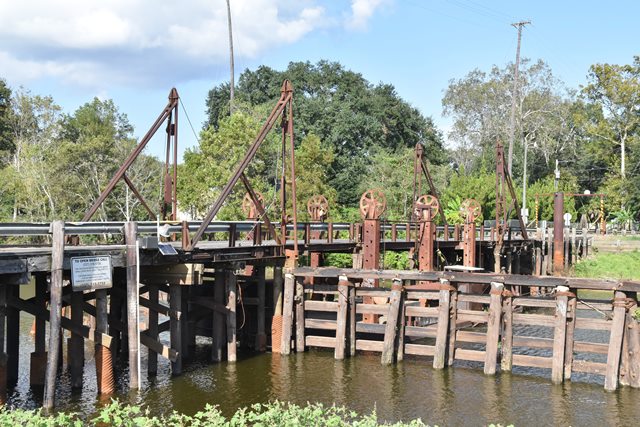
This unique bridge is the most unusual of the surviving pontoon swing bridges, a bridge type that is almost unheard of in modern times outside of Louisiana. With a pontoon swing bridge, the movable part of the bridge is a floating barge, that is physically floated away from the roadway to allow boats to pass. This pontoon bridge feautres bascule ramps that connect the fixed approach spans to the pontoon barge, and their movement not only frees the pontoon to be operated for boats, but the adjustable ramps also allow for small changes in water level. Perhaps the most unique feature of this bridge is the large tubular counterweights that parallel the roadway and are connected to sheaves. These are part of a system that allows the roadway to be adjusted and maintained at the correct elevation at significantly different water levels. These counterweights assist with an adjustment system consisting of a steel tower with support pins at 12 inch increments. The pins can be moved to different slots to adjust the roadway level. When HistoricBridges.org visited the bridge, water levels were fairly low, and the counterweights were positioned below the roadway. C. Hanchey provided additional photos in the photo gallery showing a higher water level in which the counterweights are located above the roadway level. Lastly, this video shows the bridge when water levels are very high.
Note: The main span of this bridge is a 40 foot section of roadway supported by a 52 foot long steel pontoon. HAER Documentation states the following: The bridge was moved and erected on current location ca. 1954. It was originally constructed in the 1930s in Vermillion Parish, where it reportedly crossed an oilfield canal. However it is unclear what parts of the bridge date to the 1930s and were in fact moved. The included HAER drawings show a 1951 standard plan for the pontoon.

Above: Photo from HAER Documentation showing bridge opened.
![]()
![]()
![]()

![]()
![]()
This historic bridge has been demolished. This map is shown for reference purposes only.
Coordinates (Latitude, Longitude):
Search For Additional Bridge Listings:
Bridgehunter.com: View listed bridges within 0.5 miles (0.8 kilometers) of this bridge.
Bridgehunter.com: View listed bridges within 10 miles (16 kilometers) of this bridge.
Additional Maps:
Google Streetview (If Available)
GeoHack (Additional Links and Coordinates)
Apple Maps (Via DuckDuckGo Search)
Apple Maps (Apple devices only)
Android: Open Location In Your Map or GPS App
Flickr Gallery (Find Nearby Photos)
Wikimedia Commons (Find Nearby Photos)
Directions Via Sygic For Android
Directions Via Sygic For iOS and Android Dolphin Browser
USGS National Map (United States Only)
Historical USGS Topo Maps (United States Only)
Historic Aerials (United States Only)
CalTopo Maps (United States Only)

© Copyright 2003-2024, HistoricBridges.org. All Rights Reserved. Disclaimer: HistoricBridges.org is a volunteer group of private citizens. HistoricBridges.org is NOT a government agency, does not represent or work with any governmental agencies, nor is it in any way associated with any government agency or any non-profit organization. While we strive for accuracy in our factual content, HistoricBridges.org offers no guarantee of accuracy. Information is provided "as is" without warranty of any kind, either expressed or implied. Information could include technical inaccuracies or errors of omission. Opinions and commentary are the opinions of the respective HistoricBridges.org member who made them and do not necessarily represent the views of anyone else, including any outside photographers whose images may appear on the page in which the commentary appears. HistoricBridges.org does not bear any responsibility for any consequences resulting from the use of this or any other HistoricBridges.org information. Owners and users of bridges have the responsibility of correctly following all applicable laws, rules, and regulations, regardless of any HistoricBridges.org information.
![]()