

View Information About HSR Ratings
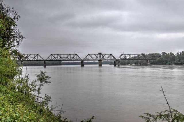
This large railroad truss swing bridge once carried highway traffic on a shared deck, until the highway bridge to the south was completed in 1971. The large fixed truss approach spans are 300 feet, and the swing span is 300 feet as well. There is one shorter through truss span near the each end of the bridge, at 150 feet each.
In 1938, the bridge was altered by the addition of truss spans. A Report of the Chief of Engineers U.S. Army (Army Corps of Engineers) stated the following:
Lengthening of the bridge over the Atchafalaya River at Simmesport, La., by the addition of two 300-foot steel truss spans on the west side of the river was completed on December 18, 1938. This work was done under a tripartite agreement between the United States, the Louisiana & Arkansas Railway, and the Louisiana Highway Commission in pursuance of the program for the improvement of the discharge capacity of the Atchafalaya River. After construction was completed, work of enlarging the river cross section by dredging along the west bank was undertaken. Cut has now been made to project depth and this section no longer constitutes a channel constriction. Further enlargement of the cut to the west to the ultimate project limits will be provided by natural river action and by such dredging as later may be found necessary.

Above: Historical photo of bridge.
![]()
![]()
![]()
Coordinates (Latitude, Longitude):
Search For Additional Bridge Listings:
Bridgehunter.com: View listed bridges within 0.5 miles (0.8 kilometers) of this bridge.
Bridgehunter.com: View listed bridges within 10 miles (16 kilometers) of this bridge.
Additional Maps:
Google Streetview (If Available)
GeoHack (Additional Links and Coordinates)
Apple Maps (Via DuckDuckGo Search)
Apple Maps (Apple devices only)
Android: Open Location In Your Map or GPS App
Flickr Gallery (Find Nearby Photos)
Wikimedia Commons (Find Nearby Photos)
Directions Via Sygic For Android
Directions Via Sygic For iOS and Android Dolphin Browser
USGS National Map (United States Only)
Historical USGS Topo Maps (United States Only)
Historic Aerials (United States Only)
CalTopo Maps (United States Only)

© Copyright 2003-2024, HistoricBridges.org. All Rights Reserved. Disclaimer: HistoricBridges.org is a volunteer group of private citizens. HistoricBridges.org is NOT a government agency, does not represent or work with any governmental agencies, nor is it in any way associated with any government agency or any non-profit organization. While we strive for accuracy in our factual content, HistoricBridges.org offers no guarantee of accuracy. Information is provided "as is" without warranty of any kind, either expressed or implied. Information could include technical inaccuracies or errors of omission. Opinions and commentary are the opinions of the respective HistoricBridges.org member who made them and do not necessarily represent the views of anyone else, including any outside photographers whose images may appear on the page in which the commentary appears. HistoricBridges.org does not bear any responsibility for any consequences resulting from the use of this or any other HistoricBridges.org information. Owners and users of bridges have the responsibility of correctly following all applicable laws, rules, and regulations, regardless of any HistoricBridges.org information.
![]()