

View Information About HSR Ratings
Location:
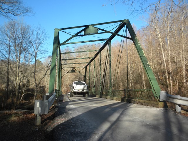
Near Hereford, Baltimore County, Maryland. A few miles west of
Interstate 83, about 35 miles north of Baltimore and 7 miles south of the
Maryland/Pennsylvania state line.
Date:
1898
Setting:
Rural,
in woods inside Gunpowder Falls State Park.
Access:
Middletown Road
exit from I-83. Parking available in small lot on western end of bridge.
Crosses:
Gunpowder Falls
Current Status:
One-lane bridge, wood
deck, carries traffic on Masemore Road, a narrow, winding two-lane road through
the State Park.
Decorations/Plaques:
Decorative plaque on truss over
roadway reads "1898, Wrought Iron Bridge Co., Canton, O". No decorative elements
other than the plaque.
Threats:
None known. The bridge is located
within a State Park, and near preserved, historical mill structures. Substantial
development which would increase traffic needs beyond the bridge's capability is
unlikely.
Built in 1898, this is a late example of the Wrought Iron Bridge Company, and it displays the a-frame portal bracing typical of late examples of this company. The bridge is noted for its skew, which was uncommon among 19th Century pin-connected highway truss bridges.
![]()
![]()
![]()
Coordinates (Latitude, Longitude):
Search For Additional Bridge Listings:
Bridgehunter.com: View listed bridges within 0.5 miles (0.8 kilometers) of this bridge.
Bridgehunter.com: View listed bridges within 10 miles (16 kilometers) of this bridge.
Additional Maps:
Google Streetview (If Available)
GeoHack (Additional Links and Coordinates)
Apple Maps (Via DuckDuckGo Search)
Apple Maps (Apple devices only)
Android: Open Location In Your Map or GPS App
Flickr Gallery (Find Nearby Photos)
Wikimedia Commons (Find Nearby Photos)
Directions Via Sygic For Android
Directions Via Sygic For iOS and Android Dolphin Browser
USGS National Map (United States Only)
Historical USGS Topo Maps (United States Only)
Historic Aerials (United States Only)
CalTopo Maps (United States Only)

© Copyright 2003-2024, HistoricBridges.org. All Rights Reserved. Disclaimer: HistoricBridges.org is a volunteer group of private citizens. HistoricBridges.org is NOT a government agency, does not represent or work with any governmental agencies, nor is it in any way associated with any government agency or any non-profit organization. While we strive for accuracy in our factual content, HistoricBridges.org offers no guarantee of accuracy. Information is provided "as is" without warranty of any kind, either expressed or implied. Information could include technical inaccuracies or errors of omission. Opinions and commentary are the opinions of the respective HistoricBridges.org member who made them and do not necessarily represent the views of anyone else, including any outside photographers whose images may appear on the page in which the commentary appears. HistoricBridges.org does not bear any responsibility for any consequences resulting from the use of this or any other HistoricBridges.org information. Owners and users of bridges have the responsibility of correctly following all applicable laws, rules, and regulations, regardless of any HistoricBridges.org information.
![]()