

View Information About HSR Ratings

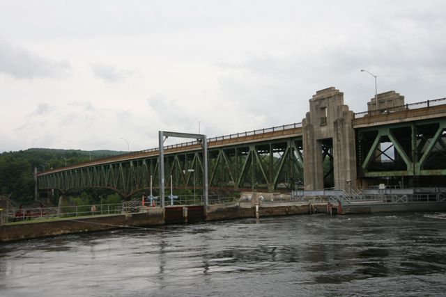
This bridge was originally and should still be properly known today as the Turners Falls - Gill Bridge but is today listed on many sources as the Gill - Montague Bridge. This name has spread because the local school district for the towns of Gill and Montague is called the Gill-Montague School District. The bridge is a low-level cantilever deck truss of considerable length. It includes a single Warren deck truss approach span at each end of the bridge, and an overpass span on the Turners Falls side.
The bridge is historically significant as a bridge built with federal Depression relief programs and funding. The bridge is technologically significant for its considerable size and complex design. The bridge is aesthetically significant for its art deco details. The most noteworthy architectural treatment is the fancy piers that rise above the deck with substantial art deco detailing and large bronze plaques.
The bridge appears to retain excellent historic integrity, including attractive metal pedestrian railings and minimal insensitive alterations to the trusses.
This bridge was rehabilitated in 2013. As is shown from the photo to the right from October 2013, this project included repainting the bridge.
![]()
![]()
![]()
Coordinates (Latitude, Longitude):
Search For Additional Bridge Listings:
Bridgehunter.com: View listed bridges within 0.5 miles (0.8 kilometers) of this bridge.
Bridgehunter.com: View listed bridges within 10 miles (16 kilometers) of this bridge.
Additional Maps:
Google Streetview (If Available)
GeoHack (Additional Links and Coordinates)
Apple Maps (Via DuckDuckGo Search)
Apple Maps (Apple devices only)
Android: Open Location In Your Map or GPS App
Flickr Gallery (Find Nearby Photos)
Wikimedia Commons (Find Nearby Photos)
Directions Via Sygic For Android
Directions Via Sygic For iOS and Android Dolphin Browser
USGS National Map (United States Only)
Historical USGS Topo Maps (United States Only)
Historic Aerials (United States Only)
CalTopo Maps (United States Only)

© Copyright 2003-2025, HistoricBridges.org. All Rights Reserved. Disclaimer: HistoricBridges.org is a volunteer group of private citizens. HistoricBridges.org is NOT a government agency, does not represent or work with any governmental agencies, nor is it in any way associated with any government agency or any non-profit organization. While we strive for accuracy in our factual content, HistoricBridges.org offers no guarantee of accuracy. Information is provided "as is" without warranty of any kind, either expressed or implied. Information could include technical inaccuracies or errors of omission. Opinions and commentary are the opinions of the respective HistoricBridges.org member who made them and do not necessarily represent the views of anyone else, including any outside photographers whose images may appear on the page in which the commentary appears. HistoricBridges.org does not bear any responsibility for any consequences resulting from the use of this or any other HistoricBridges.org information. Owners and users of bridges have the responsibility of correctly following all applicable laws, rules, and regulations, regardless of any HistoricBridges.org information.
![]()